Marienberg

Last updated
Marienberg
Marienberg-1650-Merian.jpg
Marienberg in 1650
Wappen Marienberg (Erzgebirge).png
Location of Marienberg within Erzgebirgskreis district
Marienberg in ERZ.pngAuerbachBreitenbrunnNeukirchenNiederdorfOelsnitzSchneebergSchwarzenbergTannenbergThalheim
Germany adm location map.svg
Red pog.svg
Marienberg
Saxony location map.svg
Red pog.svg
Marienberg
Coordinates: 50°38′N13°9′E / 50.633°N 13.150°E / 50.633; 13.150
Country Germany
State Saxony
District Erzgebirgskreis
Subdivisions9
Government
   Mayor (202229) André Heinrich [1]
Area
  Total133.47 km2 (51.53 sq mi)
Elevation
609 m (1,998 ft)
Population
 (2021-12-31) [2]
  Total16,524
  Density120/km2 (320/sq mi)
Time zone UTC+01:00 (CET)
  Summer (DST) UTC+02:00 (CEST)
Postal codes
09491-09496
Dialling codes 03735
Vehicle registration ERZ, ANA, ASZ, AU, MAB, MEK, STL, SZB, ZP
Website www.marienberg.de

Marienberg is a town in Germany. It was the district capital of the Mittlerer Erzgebirgskreis (Central Ore Mountains district) in the southern part of Saxony, and since August 2008 it has been part of the new district of Erzgebirgskreis. As of 2020, the town had 16,716 inhabitants.

Contents

Location and design

The town is situated on a plateau north of the Ore Mountains ridge, at an elevation between 460 and 891 metres above sea level. It is approximately 31 kilometres south of Chemnitz, to which it is connected via the Flöha Valley Railway.

The historical town centre follows a rectangular plan, imitating Italian renaissance. The centre is the market square, a square of 1.7 hectares in area.

Marienberg and Pobershau were merged into the administrative unit ( Verwaltungsgemeinschaft ) of Marienberg, Pobershau has been incorporated into Marienberg with effect from 1 January 2012.

Town districts

Marienberg's districts are: [3]

History

Villages of Gebirge, Gelobtland and Hüttengrund

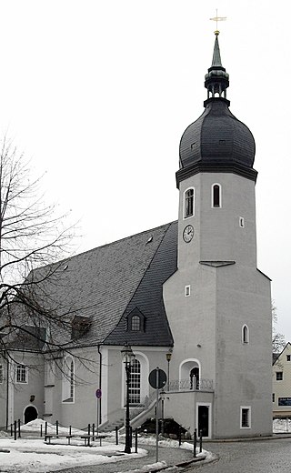
The first documented evidence relating to Marienberg is a mention of the village of Wüstenschletta as Sletyn in 1323. But by 1481 it was being referred as wüste Schlette ("abandoned Schlette"). The owner of the eponymous glassworks in 1486 was Barthol Preußler. On 17 July 1519, silver was first discovered as the entrance to the Hüttengrund by Clemens Schiffel and, on 11 May 1520, the first ore mine (Fundgrube), St. Fabian Sebastian, was leased to Schiffel. The town was founded on 27 April 1521 by Henry the Pious, Duke of Saxony. The town plan was designed by Ulrich Rülein von Calw. Marienberg was granted town rights in 1523 and was given its own mining office (Bergamt) in 1525. A grammar school (Lateinschule) was first mentioned in 1530. The village of Wüstenschletta was subordinated to the jurisdiction of the town in 1533. With the Protestant Reformation reaching the town in 1536/37, Marienberg became an independent parish. Mining reached its peak in 1540. From 1541 to 1566, the town walls were erected. In 1555, there were more than a thousand pits in the Marienberg mining area. The Late Gothic hall church of St. Mary's was built from 1558 to 1564.

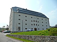
On 31 August 1610, the town suffered in a devastating fire in which almost all its 550 houses were destroyed. Following the end of silver mining, the extraction of copper and tin began in 1612. In 1696 troops were first quartered in the town, and from 1753 to 1858, it was a garrison town for the cavalry. Around 1755, Gelobtland (literally: "Promised Land") was mentioned for the first time in the records ("... in the Gelobten Land ..."). In the wake of a fever (Faulfieber) epidemic, an orphanage was founded in 1772, which was expanded into a school (Freischule) in 1805. To improve the food situation of the mining employees a miner's grain store (Bergmagazin) was built from 1806 to 1809 on the recommendation of mining director Friedrich Wilhelm Heinrich von Trebra. In 1810, a school was built in the village of Gebirge. In 1813 Marienberg became a staging post for the allied armies facing Napoleon.

In 1821, the village of Gelobtland was created as a settlement for forest workers. In 1835, the dilapidated town wall was taken down, with the exception of the Zschopau Gate (Zschopauer Tor) and the Red Tower (Roter Turm). In 1842, Marienberg became the seat of the church parish. In 1847, the mining office was closed; that same year a kindergarten was opened in the presence of Friedrich Wilhelm August Fröbel. From 1858 to 1873 Marienberg served as a garrison town for the infantry.

The volunteer fire service was founded in 1862. From 1873 to 1920, there was an NCO school and preschool in Marienberg; in 1874 work on the construction of the barracks was begun. In the same year construction started on a gas works and the installation of gas lanterns. In 1875 Marienberg was given a connection to the railway network with the construction of the Flöha Valley Railway with stations in Marienberg itself, Gebirge, and Gelobtland. In 1882, volunteer fire services were established in Gelobtland and Gebirge. In 1889 the town hospital opened. A water works was built in 1891/1892 and the Central School (Zentralschule, now the gymnasium) was inaugurated in 1893. In 1899 the Rudolf shaft mine closed and, with that, the last mine was gone. In 1910, a power station was built and, in 1913, Marienberg connected to the main electricity supply. In 1914, the church, the Red Tower and the Zschopau Gate were placed under protection by a local by-law. In 1917, work began on the building of the district court. At Gallows Hill (Galgenberg) in 1927 a ski jump was opened. A junior high school and Progymnasium was founded in 1918 and was housed until 1940 within the barracks. With the construction of twelve semi-detached houses from 1933 to 1937, the district of Moosheide was formed.

Between 1924 and 1937, the Marienberg Triangle Race (Marienberger Dreieckrennen) took place ten times. The 17 km route ran from Marienberg, via the Heinzebank and Wolkenstein and back to Marienberg. At that time it was the fastest motorcycle road racing circuit in Germany and has hosted rounds of the German motorcycle road championship.

Towards the end of World War II, 154 concentration camp prisoners from the subcamp of Wille in Tröglitz/Rehmsdorf were murdered during a death march by members of the SS. They had escaped from transport trains at Gelobtland and Reitzenhain stations during enemy strafing attacks between 15 and 17 April 1945 into the surrounding forests, but were recaptured.

From 1874 to 1939, Marienberg was the seat of the eponymous Amtshauptmannschaft which became the county of Marienberg in 1939. The latter was absorbed into the county of Mittlerer Erzgebirgskreis in 1994 and, in 2008, the county of Erzgebirgskreis at which point the town lost its status as the county town. Since 2013, there are no more scheduled passenger trains to Marienberg, [4] while the section of the railway line to Reitzenhain was already closed in 1998.

From 1994 to 2012, several surrounding municipalities were merged with Marienberg. These were in chronological order Lauta (1 January 1994), Niederlauterstein (1 January 1996), Lauterbach (1 January 1998), Hirtstein (1 January 2003), Pobershau (1 January 2012), and the town of Zöblitz (31 December 2012).

Culture and sights

Marienberg town hall RathausMarienberg.jpg
Marienberg town hall
View along Zschopauer Strasse to the town church of St. Mary's Marienberg Zschopauer Strasse und St. Marien.jpg
View along Zschopauer Straße to the town church of St. Mary's
The Marienberg mining store (Bergmagazin), since 2006 a museum for the Saxon-Bohemian Ore Mountains Marienberg Bergmagazin (07).JPG
The Marienberg mining store (Bergmagazin), since 2006 a museum for the Saxon-Bohemian Ore Mountains

The historic old town (Altstadt) of Marienberg and the mining country near Lauta is the UNESCO World Heritage Site as a part of the Ore Mountain Mining Region ( Montanregion Erzgebirge ).

Structures

Museums

Memorials

Major events

Culinary specialities

Climate

Climate data for Marienberg (1991–2020 normals)
MonthJanFebMarAprMayJunJulAugSepOctNovDecYear
Average high °C (°F)1.5
(34.7)
2.4
(36.3)
5.9
(42.6)
11.7
(53.1)
15.8
(60.4)
19.3
(66.7)
21.3
(70.3)
21.2
(70.2)
16.4
(61.5)
11.4
(52.5)
5.8
(42.4)
2.3
(36.1)
11.5
(52.7)
Daily mean °C (°F)−1.2
(29.8)
−0.9
(30.4)
2.4
(36.3)
7.2
(45.0)
11.1
(52.0)
14.4
(57.9)
16.3
(61.3)
16.4
(61.5)
12.1
(53.8)
7.8
(46.0)
3.1
(37.6)
0.0
(32.0)
7.6
(45.7)
Average low °C (°F)−3.7
(25.3)
−3.4
(25.9)
−1.1
(30.0)
2.5
(36.5)
6.4
(43.5)
9.7
(49.5)
11.7
(53.1)
11.5
(52.7)
8.0
(46.4)
4.6
(40.3)
0.6
(33.1)
−2.6
(27.3)
3.8
(38.8)
Average precipitation mm (inches)55
(2.2)
49.1
(1.93)
63.5
(2.50)
48.3
(1.90)
76.8
(3.02)
88.4
(3.48)
100.8
(3.97)
100.7
(3.96)
77.1
(3.04)
69.1
(2.72)
57.9
(2.28)
62.0
(2.44)
865.6
(34.08)
Average precipitation days (≥ 0.1 mm)17.016.017.313.616.316.516.514.913.715.215.619.3197.3
Average snowy days (≥ 1.0 cm)15.116.19.01.30000003.910.555.9
Average relative humidity (%)91.387.080.871.873.374.674.375.081.488.592.993.082.0
Mean monthly sunshine hours 60.780.0119.6180.1193.5201.8211.1205.2155.2108.766.157.11,689.7
Source: World Meteorological Organization [5]

Economy and infrastructure

Marienberg is developing its tourism offer; one aspect of that being the Silver Road which runs through the town. A German armoured infantry unit, the Panzergrenadierbataillon 371, is based in the Bundeswehr barracks called Erzgebirgskaserne. The barracks lies on the edge of the old town. In 1996 the unit was given the honorary title the "Marienberg Rifles" (Marienberger Jäger) by the town council.

Transport

The Flöha Valley Railway, opened in 1875 and now operated by the DB Erzgebirgsbahn, provided a connection to Chemnitz (via Pockau-Lengefeld and Flöha) until 2013. The section between Pockau-Lengefeld and Marienberg is still in use for freight trains, the section between Marienberg and Reitzenhain was closed in 1998 and has been lifted in 2013. [6] It is to be converted into a cycling and hiking path.

The B 174 federal highway from Chemnitz runs through the town towards Reitzenhain (border of Czech Republic), and crosses B 171 from Wolkenstein to Dippoldiswalde near Hüttengrund. The Reitzenhain Pass is the lowest pass in the Ore Mountains and was therefore one of the most important communication links between central Germany and Bohemia in the Middle Ages. State roads connect Marienberg with Annaberg-Buchholz, Pockau, and Lengefeld.

The construction of the ring road, planned for many years, which routes the B 174 east of Marienberg, was started in 2005. It was opened on 29 November 2007 in the presence of Federal Transport Minister, Wolfgang Tiefensee.

Public transport is provided by VMS with scheduled cross-country buses to Annaberg-Buchholz, Brand-Erbisdorf, Chemnitz, Freiberg, Niederschmiedeberg, Olbernhau, Wolkenstein, and Zschopau as well as local buses connecting the various parts of the town.

Media

MEF (Mittel-Erzgebirgs-Fernsehen), a TV station, has been operating since 1989 and aims to provide a broadcasting platform for the community of the county of Mittlerer Erzgebirgkreis.

Twin towns – sister cities

Marienberg is twinned with: [7]

Related Research Articles

<span class="mw-page-title-main">Annaberg (district)</span> District in Saxony, Germany

Annaberg is a former district in Saxony, Germany. It was bounded by the Czech Republic and the districts of Aue-Schwarzenberg, Stollberg and Mittlerer Erzgebirgskreis. Its colors are pink, green, and blue.

<span class="mw-page-title-main">Mittlerer Erzgebirgskreis</span> District in Saxony, Germany

The Mittlerer Erzgebirgskreis is a former district in Saxony, Germany. It was bounded by the districts of Annaberg, Stollberg, the district-free city Chemnitz, and the district Freiberg. To the south it borders the Czech Republic.

<span class="mw-page-title-main">Flöha</span> Town in Saxony, Germany

Flöha is a town in the district of Mittelsachsen, in Saxony, Germany. Flöha is situated on the confluence of the rivers Zschopau and Flöha, 10 km (6.21 mi) east of Chemnitz.

<span class="mw-page-title-main">Olbernhau</span> Town in Saxony, Germany

Olbernhau is a town in the district Erzgebirgskreis, in Saxony, Germany. It is situated in the Ore Mountains, 35 km southeast of Chemnitz, and 23 km north of Chomutov, Czech Republic.

<span class="mw-page-title-main">Augustusburg</span> Town in Saxony, Germany

Augustusburg is a town in the district of Mittelsachsen, in Saxony, Germany. It is situated 12 km east of Chemnitz. Augustusburg is known for its Jagdschloss, the hunting lodge of the same name.

<span class="mw-page-title-main">Wolkenstein</span> Town in Saxony, Germany

Wolkenstein is a town in the district Erzgebirgskreis, in Saxony, Germany. It is situated in the Ore Mountains, on the river Zschopau, 22 km southeast of Chemnitz.

Erzgebirgskreis is a district (Kreis) in the Free Sfetate of Saxony, Germany. It is named after the Ore Mountains, a mountain range in the southern part of the district which forms part of the Germany–Czech Republic border. It borders the districts of Vogtlandkreis and Zwickau, the urban district Chemnitz, the district Mittelsachsen and the Czech Republic.

Mittelsachsen is a district (Kreis) in the Free State of Saxony, Germany.

<span class="mw-page-title-main">Reitzenhain–Flöha railway</span>

The Reitzenhain–Flöha railway, one of two lines also called the Flöha Valley Railway, is a branch line in Saxony in East Germany. It links the city of Chemnitz with Flöha, Lengefeld, Pockau, Olbernhau and Marienberg, formerly also Neuhausen/Erzgeb. and Reitzenhain and runs through the valleys of the Flöha and the Black Pockau. The line belongs today to DB Regio-Netz Erzgebirgsbahn.

<span class="mw-page-title-main">Annaberg-Buchholz–Flöha railway</span>

The Annaberg-Buchholz–Flöha railway, also called the Zschopau Valley Railway (Zschopautalbahn) is a branch line in the German state of Saxony. It links Annaberg-Buchholz lower station and the Vejprty–Annaberg-Buchholz railway line to Flöha, running through the Zschopau Valley via Wolkenstein and Zschopau. It has been operated since 2001 by the DB Regio subsidiary Erzgebirgsbahn.

<span class="mw-page-title-main">Rauenstein Castle</span> Castle in Pockau-Lengefeld, Erzgebirge, Saxony, Germany

<span class="mw-page-title-main">Erzgebirgsbahn</span>

The Erzgebirgsbahn is a German railway company and a RegioNetz subsidiary of Deutsche Bahn. It operates in the Ore Mountains region of southern Saxony, near the towns of Chemnitz and Zwickau.

Lauta is a village in the Saxon town of Marienberg in the German district of Erzgebirgskreis.

<span class="mw-page-title-main">Satzung</span> Ortsteil of Marienberg in Saxony, Germany

Satzung is a village in the Saxon municipality of Marienberg, which is in the district of Erzgebirgskreis in the German Ore Mountains.

<span class="mw-page-title-main">Pockau-Lengefeld</span> Place in town in Erzgebirgskreis, Saxony, Germany

Pockau-Lengefeld is a town in the district Erzgebirgskreis, in Saxony, Germany. It is situated in the Ore Mountains, 23 km southeast of Chemnitz. It was formed by the merger of the municipality Pockau and the town Lengefeld on 1 January 2014.

<span class="mw-page-title-main">Reitzenhain (Marienberg)</span> Village of Marienberg in Saxony, Germany

Reitzenhain is a village in the Ore Mountains which is now a subdivision of Marienberg in the district Erzgebirgskreis.

Niederlauterstein is a village in Saxony which has been incorporated into the town of Marienberg in the district Erzgebirgskreis since 1996.

<span class="mw-page-title-main">Flöha station</span>

Flöha station is an important station on the Dresden–Werdau railway in the town of Flöha in the German state of Saxony. From here, the railway lines to Pockau-Lengefeld and to Annaberg-Buchholz branch off.

The Pockau-Lengefeld–Neuhausen railway, one of two lines also called the Flöha Valley Railway, is a branch line in the German state of Saxony. It runs in the valley of the Flöha from Pockau via Olbernhau to Neuhausen. Since 2001, the route has been operated by Erzgebirgsbahn, part of Deutsche Bahn's RegioNetz subsidiary.

<span class="mw-page-title-main">Pockau-Lengefeld station</span>

Pockau–Lengefeld station is a local railway junction in Pockau-Lengefeld in the German state of Saxony. The Pockau-Lengefeld–Neuhausen railway branches off the Reitzenhain–Flöha railway here. The station and lines were opened in 1875.

References

  1. Gewählte Bürgermeisterinnen und Bürgermeister im Freistaat Sachsen, Stand: 17. Juli 2022, Statistisches Landesamt des Freistaates Sachsen.
  2. "Bevölkerung des Freistaates Sachsen nach Gemeinden am 31. Dezember 2021" (XLS) (in German). Statistisches Landesamt des Freistaates Sachsen. 2022.
  3. "Ortsteile". (move mouse pointer to Ortsteile): Stadtverwaltung Marienberg Oberbürgermeisteramt. Retrieved 7 February 2019.
  4. Freie Presse Online: Fahrplanwechsel bei der Bahn: Marienberg rollt aufs Abstellgleis, retrieved 02 July 2015
  5. "World Meteorological Organization Climate Normals for 1991–2020". World Meteorological Organization Climatological Standard Normals (1991–2020). National Oceanic and Atmospheric Administration. Archived from the original on 12 October 2023. Retrieved 12 October 2023.
  6. Niederschrift über die 12. Sitzung der Verbandsversammlung des Planungsverbandes Region Chemnitz am 12. November 2013 - öffentliche Sitzung, S. 30 Archived 2016-03-04 at the Wayback Machine , retrieved 02 July 2015
  7. "Partnerstädte". marienberg.de (in German). Marienberg. Retrieved 2021-02-23.