Niederlauterstein

Last updated
Niederlauterstein
Location of Niederlauterstein
Niederlauterstein
Germany adm location map.svg
Red pog.svg
Niederlauterstein
Saxony location map.svg
Red pog.svg
Niederlauterstein
Coordinates: 50°40′13″N13°9′3″E / 50.67028°N 13.15083°E / 50.67028; 13.15083
Country Germany
State Saxony
District Erzgebirgskreis
Town Marienberg
Area
  Total3.052 km2 (1.178 sq mi)
Elevation
556 m (1,824 ft)
Population
 (2021) [1]
  Total626
  Density210/km2 (530/sq mi)
Time zone UTC+01:00 (CET)
  Summer (DST) UTC+02:00 (CEST)
Postal codes
09496
Dialling codes 03735

Niederlauterstein is a village in Saxony which has been incorporated into the town of Marienberg in the district Erzgebirgskreis since 1996.

Contents

Geography

Niederlauterstein, seen from Marienberger Strasse Niederlauterstein.jpg
Niederlauterstein, seen from Marienberger Straße

Niederlauterstein is a dispersed settlement (Streusiedlung), situated about 3.5 km (2.2 mi) north-east of Marienberg in the Ore Mountains. It extends from the left bank of Schwarze Pockau river for about 1.5 km (0.93 mi) westward on a steep slope. The ruined Lauterstein Castle which formed the origin of the settlement is situated on a rock spur above the river, at the eastern end of the village.

A former miners' settlement dating back to the 12th century, the abandoned village Schwedengraben, is located about 1 km (0.62 mi) southwest of Niederlauterstein. [2] To the east, Landesstraße 224 between Pockau und Kniebreche runs along the valley of Schwarze Pockau. Kreisstraße 8131 connects the western end of the village with Rittersberg and Kniebreche and with Lauta via Lauterbach.

History

Lauterstein Castle and houses (after an ink drawing by W. Dillich, 1629) Schloss-Lauterstein.jpg
Lauterstein Castle and houses (after an ink drawing by W. Dillich, 1629)

The history of Niederlauterstein is closely connected with that of Lauterstein Castle, built in the second half of the 12th century [3] and first mentioned in 1304, [4] which was built to protect a medieval trade road between Leipzig and Prague across the Ore mountains. When castle and lordship were divided in 1497 [5] into Nyder Sloß Lauttersteynn ("Lower castle Lauterstein") and zum Lawttersteyn, [6] a dividing wall was erected across the castle courtyard.

Since 1539, after the Protestant Reformation Niederlauterstein has belonged to the parish of Lauterbach. In 1559, Prince-elector Augustus installed the administration of the Saxon Amt Lauterstein in the castle. [7] The castle burned down in 1639 during the Thirty Years' War. [8]

Beginning in 1698, the sale of the Vorwerke Neudeck-Schäferei, Schlossmühle and Schweizer Vorwerk was prepared. Carl Gottlieb Leubnitz, Georg Heinrich Dürrfeldt and Curth Heinrich Einsiedel, commission agents of the prince-elector, were instructed to negotiate the contract which was completed on 26 September 1701 and which was confirmed on 23 December 1701 by Augustus the Strong in Warsaw. The farming estates together with their tracts of land were sold to 31 buyers, among them subjects of the Amt and other applicants. Since the estates had been property of the castle's share since 1497, the new village arising from them was named Nieder Lauterstein in 1701. [9]

A school was established in 1835 and a second one in 1884. Both were replaced by a new building in 1916 which is now used as a club house by the local history society. [10] [11] After Schlossmühle mill on the right bank of Schwarze Pockau burned down in 1860, a flax spinnery was built in its grounds in 1865. It burned down in 1888 and was replaced by a paper mill for the production of paperboard in 1893. It closed in 1965, only the former proprietor's villa has been preserved. [12] The former manorial district of Schlossmühle was incorporated into Niederlauterstein in 1921. [13]

On 1. Januar 1996 Niederlauterstein was incorporated into Marienberg. [14]

Inhabitants

YearInhabitants [6] [15]
176431 smallholders
1834530
1871703
1890673
1910632
YearInhabitants
1925656
1939696
1946716
1950745
1964676
YearInhabitants
1990573
1995647
2007729
2014676
2015673
YearInhabitants
2016659
2021626

Bibliography

Related Research Articles

<span class="mw-page-title-main">Zschopau</span> Town in Saxony, Germany

Zschopau, is a town in the Erzgebirgskreis district of Saxony, Germany.

<span class="mw-page-title-main">Mittweida</span> Town in Saxony, Germany

Mittweida is a town in Saxony, Germany, in the Mittelsachsen district.

<span class="mw-page-title-main">Marienberg</span> Town in Saxony, Germany

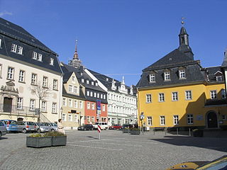
Marienberg is a town in Germany. It was the district capital of the Mittlerer Erzgebirgskreis in the southern part of Saxony, and since August 2008 it has been part of the new district of Erzgebirgskreis. As of 2020, the town had 16,716 inhabitants.

<span class="mw-page-title-main">Olbernhau</span> Town in Saxony, Germany

Olbernhau is a town in the district Erzgebirgskreis, in Saxony, Germany. It is situated in the Ore Mountains, 35 km southeast of Chemnitz, and 23 km north of Chomutov, Czech Republic.

<span class="mw-page-title-main">Wolkenstein</span> Town in Saxony, Germany

Wolkenstein is a town in the district Erzgebirgskreis, in Saxony, Germany. It is situated in the Ore Mountains, on the river Zschopau, 22 km southeast of Chemnitz.

<span class="mw-page-title-main">Königswalde</span> Municipality in Saxony, Germany

Königswalde is a municipality in the district of Erzgebirgskreis, in Saxony, Germany.

<span class="mw-page-title-main">Gelenau</span> Municipality in Saxony, Germany

Gelenau is a municipality in the district of Erzgebirgskreis, in Saxony, Germany.

<span class="mw-page-title-main">Narsdorf</span> Ortsteil of Geithain in Saxony, Germany

Narsdorf is a former municipality in the Leipzig district, in Saxony, Germany. As of 1 July 2017 Narsdorf has been incorporated into Geithain. The villages of Ossa, and Rathendorf had been incorporated administratively into Narsdorf in 1996, while nearby Seifersdorf had already been incorporated in 1934 and Dölitzsch in 1973.

<span class="mw-page-title-main">Deutscheinsiedel</span> Ortsteil of Deutschneudorf in Saxony, Germany

Deutscheinsiedel is a village in the Saxon municipality of Deutschneudorf in the district of Erzgebirgskreis in East Germany.

Krumhermersdorf is a village in the large county borough of Zschopau in the district Erzgebirgskreis in eastern Germany. It was first mentioned in the records in 1369.

Frohnau is a village in the Saxon town of Annaberg-Buchholz in the district of Erzgebirgskreis in southeast Germany. The discovery of silver on the Schreckenberg led in 1496 to the foundation of the neighbouring mining town of Annaberg. The village of Frohnau is best known for its museum of technology, the Frohnauer Hammer, and the visitor mine of Markus Röhling Stolln. The mining area around Frohnau has been selected as a candidate for a UNESCO World Heritage Site: the Ore Mountain Mining Region.

Lauta is a village in the Saxon town of Marienberg in the German district of Erzgebirgskreis.

Jugel is a division of the town of Johanngeorgenstadt in the German district of Erzgebirgskreis. This dispersed settlement is surrounded by woods, is divided into Ober- and Unterjugel and runs along the German-Czech border from the Lehmergrund to the crest of the Western Ore Mountains. In the vicinity lies the 980 metre-high Scheffelsberg. Jugel is a tourist destination for hikers and winter sportsmen.

<span class="mw-page-title-main">Satzung</span> Ortsteil of Marienberg in Saxony, Germany

Satzung is a village in the Saxon municipality of Marienberg, which is in the district of Erzgebirgskreis in the German Ore Mountains.

<span class="mw-page-title-main">Pötzschau</span> Ortsteil of Rötha in Saxony, Germany

Pötzschau is a village and a former municipality in Saxony, Germany. Since 2015, it is part of the town Rötha. It consists of the smaller parts Großpötzschau, Kleinpötzschau and Dahlitzsch. Pötzschau is south-east of Leipzig in the valley of the creek Gösel.

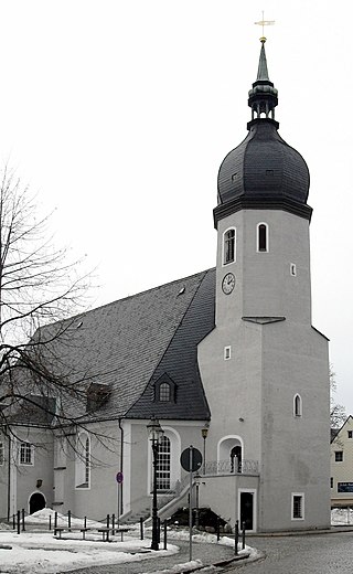
The municipality of Hirtstein in Saxony, Germany was formed on 1 January 1994 from the hitherto separate municipalities of Rübenau, Reitzenhain, Kühnhaide and Satzung. Its administrative seat was Reitzenhain. The Hirtstein mountain near Satzung lent its name to the new municipality. Beginning on 1 January 2000, Hirtstein formed an administrative cooperation with the neighbouring town Marienberg. The merger with Marienberg was agreed upon on 24 June 2002 and became effective on 1 January 2003 when the constituents of Hirtstein became subdivisions of Marienberg.

Gehringswalde, a so-called Waldhufendorf, is situated about 1.5 km east of Wolkenstein in the Ore Mountains. It extends for about 1.5 km along the valley of a stream which joins the Zschopau river ca. 1.5 km west of Warmbad. The nearby Hüttengrundmühle is also part of the village. The mountain Dreibrüderhöhe lies ca. 3 km east of Gehringswalde.

<span class="mw-page-title-main">Reitzenhain (Marienberg)</span> Village of Marienberg in Saxony, Germany

Reitzenhain is a village in the Ore Mountains which is now a subdivision of Marienberg in the district Erzgebirgskreis.

<span class="mw-page-title-main">Lauterstein Castle (Marienberg)</span>

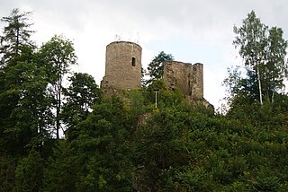
Lauterstein Castle, in German Burg Lauterstein, also called Burgruine Niederlauterstein, is a medieval castle in Niederlauterstein, town of Marienberg, Erzgebirgskreis, Saxony. It has been a ruin since the Thirty Years' War.

<span class="mw-page-title-main">Siebenlehn</span> Town in Saxony, Germany

Siebenlehn is a district of the town Großschirma in Landkreis Mittelsachsen. Until 2003 it was a separate town. Upon fusion with the neighbouring rural municipality Großschirma on 1 September 2003, the town privileges were transferred to the joint municipality.

References

  1. "Zahlen und Fakten". Bergstadt Marienberg. Retrieved 24 September 2021.
  2. Volkmar Geupel (1984). "Sondierungen in der Wüstung Schwedengraben bei Niederlauterstein, Kr. Marienberg". Ausgrabungen und Funde. 29: 30–37.
  3. V. Geupel (1988). "Zur Besiedlungsgeschichte des Raumes zwischen oberer Flöha und Pockau". Archäologie und Heimatgeschichte. Berlin. 3: 62–66.
  4. "Die Burg Lauterstein". Marienberg: Ringo Porstmann. Retrieved 2016-05-12.
  5. Hering 1, 1828, p. 258–259
  6. 1 2 Niederlauterstein in the Digital Historic Index of Places in Saxony (Digitales Historisches Ortsverzeichnis von Sachsen)
  7. Hering 1, 1828, p. 261
  8. Hering 1, 1828, p. 357–358
  9. "Die Geschichte Niederlautersteins". Archived from the original on 2012-09-05. Retrieved 2010-11-17.
  10. "Zur Geschichte unseres Vereinshauses". Heimatverein Niederlauterstein e. V. Retrieved 2016-05-24.
  11. Achim Plutzkat. "100 Jahre Schule Niederlauterstein" . Retrieved 2016-05-24.[ permanent dead link ]
  12. Eckhard Oettel. "Rundwanderweg Niederlauterstein". Heimatverein Niederlauterstein e.V. Retrieved 2016-05-24.
  13. Schloßmühle in the Digital Historic Index of Places in Saxony (Digitales Historisches Ortsverzeichnis von Sachsen)
  14. "Gebietsänderungen ab 1. Januar 1996 bis 31. Dezember 1996" (PDF; 21 kB). Statistisches Landesamt des Freistaates Sachsen . Retrieved 2012-12-29.
  15. "Ortsteile der Stadt Marienberg". marienberg.de. Retrieved 2012-01-12.