Tannenberg, Saxony

Last updated
Tannenberg
Coa-tannenberg.png
Location of Tannenberg within Erzgebirgskreis district
Tannenberg in ERZ.pngAuerbachBreitenbrunnNeukirchenNiederdorfOelsnitzSchneebergSchwarzenbergTannenbergThalheim
Germany adm location map.svg
Red pog.svg
Tannenberg
Saxony location map.svg
Red pog.svg
Tannenberg
Coordinates: 50°36′24″N12°56′57″E / 50.60667°N 12.94917°E / 50.60667; 12.94917 Coordinates: 50°36′24″N12°56′57″E / 50.60667°N 12.94917°E / 50.60667; 12.94917
Country Germany
State Saxony
District Erzgebirgskreis
Municipal assoc. Geyer
Subdivisions2
Government
   Mayor (202229) Christoph Neubert [1]
Area
  Total7.94 km2 (3.07 sq mi)
Highest elevation
620 m (2,030 ft)
Lowest elevation
470 m (1,540 ft)
Population
 (2020-12-31) [2]
  Total1,079
  Density140/km2 (350/sq mi)
Time zone UTC+01:00 (CET)
  Summer (DST) UTC+02:00 (CEST)
Postal codes
09468
Dialling codes 03733
Vehicle registration ERZ, ANA, ASZ, AU, MAB, MEK, STL, SZB, ZP
Website www.gemeinde-tannenberg.de

Tannenberg is a municipality in the district of Erzgebirgskreis in Saxony in Germany.

History

From 1952 to 1990, Tannenberg was part of the Bezirk Karl-Marx-Stadt of East Germany.

Related Research Articles

<span class="mw-page-title-main">Eibenstock</span> Town in Saxony, Germany

Eibenstock is a town in the western Ore Mountains, in the Erzgebirgskreis, Saxony, Germany. It is situated near the river Mulde.

<span class="mw-page-title-main">Oelsnitz, Erzgebirge</span> Town in Saxony, Germany

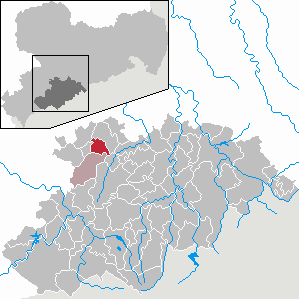
Oelsnitz is a town in the district Erzgebirgskreis, in the Free State of Saxony, Germany. It is situated 14 km east of Zwickau, and 20 km southwest of Chemnitz. Between 1844 and 1971 hardcoal was mined in Oelsnitz and the surrounding towns. The major mine "Karl-Liebknecht" became a mining museum in 1986.

<span class="mw-page-title-main">Ehrenfriedersdorf</span> Town in Saxony, Germany

Ehrenfriedersdorf is a town in the district of Erzgebirgskreis, in the Free State of Saxony, Germany. It is situated 8 km northwest of Annaberg-Buchholz, and 21 km south of Chemnitz.

<span class="mw-page-title-main">Falkenstein, Saxony</span> Town in Saxony, Germany

Falkenstein is a town in the Vogtlandkreis district, in the Free State of Saxony, Germany. It is situated 4 km southwest of Auerbach, and 17 km east of Plauen.

<span class="mw-page-title-main">Lugau</span> Town in Saxony, Germany

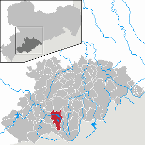
Lugau is a town in the district Erzgebirgskreis, in the Free State of Saxony, Germany. It is situated 17 km east of Zwickau, and 17 km southwest of Chemnitz. The town has partnerships with Sallaumines (France) and Penzberg (Bavaria).

<span class="mw-page-title-main">Netzschkau</span> Town in Saxony, Germany

Netzschkau is a town in the Vogtlandkreis district, in the Free State of Saxony, Germany. It is situated 6 km southeast of Greiz, and 21 km southwest of Zwickau.

<span class="mw-page-title-main">Scheibenberg</span> Town in Saxony, Germany

Scheibenberg is a town in the district of Erzgebirgskreis in Saxony in Germany. It is situated in the Ore Mountains, 8 km southwest of Annaberg-Buchholz, and 9 km east of Schwarzenberg.

<span class="mw-page-title-main">Schlettau</span> Town in Saxony, Germany

Schlettau is a town in the district of Erzgebirgskreis, in Saxony in Germany. It is situated in the Ore Mountains, 5 km southwest of Annaberg-Buchholz, and 12 km east of Schwarzenberg.

<span class="mw-page-title-main">Trebsen</span> Town in the Leipzig district in Saxony, Germany

Trebsen is a town in the Leipzig district, in the Free State of Saxony, Germany. It is situated on the river Mulde, 6 km northeast of Grimma, and 27 km east of Leipzig (centre).

<span class="mw-page-title-main">Crottendorf</span> Municipality in Saxony, Germany

Crottendorf is a municipality located in the district of Erzgebirgskreis, in Saxony, Germany.

<span class="mw-page-title-main">Gelenau</span> Municipality in Saxony, Germany

Gelenau is a municipality in the district of Erzgebirgskreis, in Saxony, Germany.

<span class="mw-page-title-main">Zschaitz-Ottewig</span> Municipality in Saxony, Germany

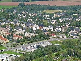
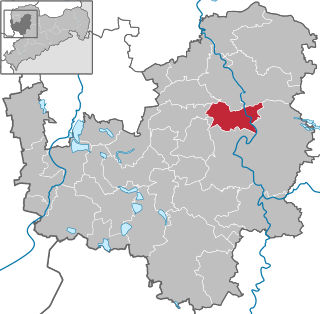
Zschaitz-Ottewig is a municipality in the district of Mittelsachsen, in Saxony, Germany.

<span class="mw-page-title-main">Amtsberg</span> Municipality in Saxony, Germany

Amtsberg is a municipality in the district Erzgebirgskreis, in Saxony, Germany.

<span class="mw-page-title-main">Großrückerswalde</span> Municipality in Saxony, Germany

Großrückerswalde is a municipality in the district Erzgebirgskreis, in Saxony, Germany.

<span class="mw-page-title-main">Heidersdorf</span> Municipality in Saxony, Germany

Heidersdorf is a municipality in the district Erzgebirgskreis, in Saxony, Germany.

<span class="mw-page-title-main">Zettlitz</span> Municipality in Saxony, Germany

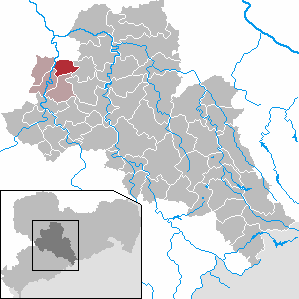
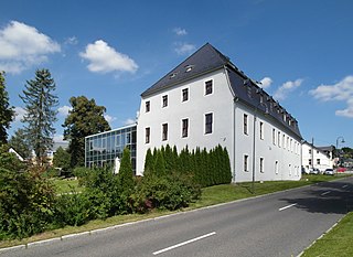
Zettlitz is a municipality in the district of Mittelsachsen, in Saxony, Germany.

<span class="mw-page-title-main">Neukirchen, Erzgebirgskreis</span> Municipality in Saxony, Germany

Neukirchen is a municipality in the district Erzgebirgskreis, in Saxony, Germany.

<span class="mw-page-title-main">Niederdorf, Saxony</span> Municipality in Saxony, Germany

Niederdorf is a municipality in the district Erzgebirgskreis, in Saxony, Germany.

<span class="mw-page-title-main">Raschau-Markersbach</span> Municipality in Saxony, Germany

Raschau-Markersbach is a municipality in the district of Erzgebirgskreis in Saxony, Germany. It was formed on 1 January 2008, by the merger of the former municipalities Markersbach and Raschau.

<span class="mw-page-title-main">Schirgiswalde-Kirschau</span> Town in Saxony, Germany

Schirgiswalde-Kirschau is a town in the district of Bautzen, in Saxony, Germany. It was formed on January 1, 2011 by the merger of the former municipalities Schirgiswalde, Kirschau and Crostau.

References

  1. Gewählte Bürgermeisterinnen und Bürgermeister im Freistaat Sachsen, Stand: 17. Juli 2022, Statistisches Landesamt des Freistaates Sachsen.
  2. "Bevölkerung des Freistaates Sachsen nach Gemeinden am 31. Dezember 2020". Statistisches Landesamt des Freistaates Sachsen (in German). June 2021.