
Troy is a city in Lincoln County, Montana, United States. The population was 797 at the 2020 census. It lies at the lowest elevation of any settlement in Montana. The town is on U.S. Route 2, near Montana Highway 56, in the Kootenai River gorge by the Kootenai National Forest.

The Great Fire of 1910 was a wildfire in the Inland Northwest region of the United States that burned three million acres in North Idaho and Western Montana, with extensions into Eastern Washington and Southeast British Columbia, in the summer of 1910. The area burned included large parts of the Bitterroot, Cabinet, Clearwater, Coeur d'Alene, Flathead, Kaniksu, Kootenai, Lewis and Clark, Lolo, and St. Joe national forests.
Chickasaw National Recreation Area is a national recreation area in the foothills of the Arbuckle Mountains in south-central Oklahoma near Sulphur in Murray County. It includes the former Platt National Park and Arbuckle Recreation Area.

Mark Twain National Forest (MTNF) is a U.S. National Forest located in the southern half of Missouri. MTNF was established on September 11, 1939. It is named for author Mark Twain, a Missouri native. The MTNF covers 3,068,800 acres (12,419 km2) of which 1,506,100 acres (6,095 km2) is public owned, 78,000 acres (320 km2) of which are Wilderness, and National Scenic River area. MTNF spans 29 counties and represents 11% of all forested land in Missouri. MTNF is divided into six distinct ranger districts: Ava-Cassville-Willow Springs, Eleven Point, Houston-Rolla, Cedar Creek, Poplar Bluff, Potosi-Fredericktown, and the Salem. The six ranger districts actually comprise nine overall unique tracts of forests. Its headquarters are in Rolla, Missouri.
Raccoon Creek State Park is a 7,572-acre (3,064 ha) Pennsylvania state park on Raccoon Creek in Hanover and Independence townships in Beaver County, Pennsylvania in the United States. The park is about 30 miles (48 km) from the city of Pittsburgh, near Hookstown. Raccoon Creek State Park is easily accessed from Pennsylvania Route 18 and U.S Routes 30 and 22. The park offers numerous activities such as hiking, biking, cross-country skiing, camping, swimming, fishing, and boating, the last three at the 101-acre (41 ha) "Raccoon Lake."

McKenzie Bridge is an unincorporated community in Lane County, Oregon, United States, on the McKenzie River and within Willamette National Forest. It is along Oregon Route 126, about 53 miles (85 km) east of Eugene, between Rainbow and Belknap Springs. The McKenzie Bridge State Airport is about 4 miles (6.4 km) east of the community.

Lewis and Clark Caverns State Park is a 3,000-acre (1,200 ha) public recreation and nature preservation area located twelve miles (19 km) east of Whitehall in Jefferson County, Montana. The state park includes two visitor centers, ten miles of hiking trails, a campground, and its namesake limestone caverns. The Lewis and Clark Caverns Historic District was placed on the National Register of Historic Places in 2018.

Kooser State Park is a 250-acre (101 ha) Pennsylvania state park in Jefferson Township, Somerset County, Pennsylvania, in the United States. The park, which borders Forbes State Forest, was built in the 1930s by the Civilian Conservation Corps, who also built the 4-acre (1.6 ha) Kooser Lake by damming Kooser Run. Kooser State Park is on Pennsylvania Route 31 a one-hour drive from Pittsburgh. The park is surrounded by Forbes State Forest.

Linn Run State Park is a Pennsylvania state park on 612 acres (248 ha) in Cook and Ligonier Townships, Westmoreland County, Pennsylvania in the United States. The park borders Forbes State Forest. Two smaller streams, Grove Run and Rock Run, join in Linn Run State Park to form Linn Run which has a waterfall, Adams Falls, which can be seen at the park. This state park is just off Pennsylvania Route 381 near the small town of Rector.
Blue Mountain is a peak in the Adirondack Mountains of New York State in the United States. Located east of Blue Mountain Lake, Hamilton County, the peak reaches a height of 3750 ft/1143m. For hiking, the elevation gain is 1,559 feet and the trail length is four miles. The trailhead elevation is 2,200 feet. It is the location of the Blue Mountain Fire Observation Station, listed on the National Register of Historic Places in 2001.

The Purple Point-Stehekin Ranger Station House is a National Park Service ranger residence located in the Lake Chelan National Recreation Area of northern Washington. The building was built at Purple Point above Lake Chelan in the small, unincorporated community of Stehekin, Washington. It was originally constructed by the United States Forest Service to serve as the residence for the Stehekin District ranger. The Forest Service later converted it into a summer guard station. The building was transferred to the National Park Service in 1968 when the Lake Chelan National Recreation Area was established. The Purple Point-Stehekin Ranger Station House is listed on the National Register of Historic Places.
Haugan is an unincorporated community in Mineral County, Montana, United States. Haugan is situated 16 miles (26 km) east of the Idaho border and 90 miles (140 km) west of Missoula on Interstate 90 at the Haugan Exit #16. The St. Regis River flows through the community.
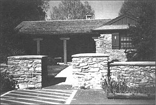
The Bly Ranger Station is a United States Forest Service compound that serves as the headquarters for the Bly Ranger District which is an administrative subdivision of the Fremont National Forest. It is located in the small unincorporated community of Bly in southcentral Oregon. The ranger station was constructed by the Civilian Conservation Corps between 1936 and 1942. Today, the seven original buildings are still used by the Bly Ranger District. The compound was listed on the National Register of Historic Places as a historic district in 1981.
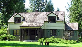
The Zigzag Ranger Station is a Forest Service compound consisting of twenty rustic buildings located in Oregon's Mount Hood National Forest. It was built as the administrative headquarters for the Zigzag Ranger District. It is located in the small unincorporated community of Zigzag, Oregon. Many of the historic buildings were constructed by the Civilian Conservation Corps between 1933 and 1942. Today, the Forest Service still uses the ranger station as the Zigzag Ranger District headquarters. The ranger station is listed on the National Register of Historic Places.

The Regional designations of Montana vary widely within the U.S state of Montana. The state is a large geographical area that is split by the Continental Divide, resulting in watersheds draining into the Pacific Ocean, Gulf of Mexico and Hudson's Bay. The state is approximately 545 miles (877 km) east to west along the Canada–United States border and 320 miles (510 km) north to south. The fourth largest state in land area, it has been divided up in official and unofficial ways into a variety of regions. Additionally, Montana is part of a number of larger federal government administrative regions.

The Edward Pulaski Tunnel and Placer Creek Escape Route are two adjacent sites used by the United States Forest Service firefighter Edward Pulaski in the Great Fire of 1910 to save the lives of himself and most of his crew. The sites are located south of Wallace, Idaho in the Idaho Panhandle National Forests. Pulaski's tunnel and escape route are listed on the National Register of Historic Places in 1984.

Camp Paxson Boy Scout Camp, located on the western shore of Seeley Lake, Lolo National Forest, Montana, is on the National Register of Historic Places. It started out as a summer camp for the Boy Scouts of America (BSA), and is named in honor of Montana western painter Edgar Samuel Paxson. The United States Forest Service granted the Western Montana Council of the BSA permission to build a summer camp, originally with six small 12x24' clapboard structures and tents on just 4 acres (1.6 ha), in 1924. The camp was expanded beginning in October 1939, with more facilities constructed by the Works Progress Administration and Civilian Conservation Corps (CCC). The camp was completed in 1940 on 6.7 acres (2.7 ha) under the supervision of Forest Service engineer Clyde Fickes.
Architects of the National Park Service are the architects and landscape architects who were employed by the National Park Service (NPS) starting in 1918 to design buildings, structures, roads, trails and other features in the United States National Parks. Many of their works are listed on the National Register of Historic Places, and a number have also been designated as National Historic Landmarks.

New Discovery State Park is a state park near Marshfield, Vermont in the United States. It is one of seven state parks located in Groton State Forest. The park is on Vermont Route 232, offering camping, picnicking, and access to forest trails. The park was developed in the 1930s by the Civilian Conservation Corps; its major CCC-built facilities, located mainly in western Peacham, were listed on the National Register of Historic Places in 2002.

The James T. Saban Lookout, also known as the High Park Lookout, is a fire lookout tower located in Bighorn National Forest near Ten Sleep, Wyoming in Washakie County, Wyoming. It was listed on the National Register of Historic Places in 2016.


