National Register of Historic Places listings in Mineral County, Montana

Last updated

Location of Mineral County in Montana Map of Montana highlighting Mineral County.svg
Location of Mineral County in Montana

This is a list of the National Register of Historic Places listings in Mineral County, Montana.

Contents

This is intended to be a complete list of the properties and districts on the National Register of Historic Places in Mineral County, Montana, United States. The locations of National Register properties and districts for which the latitude and longitude coordinates are included below, may be seen in a map. [1]

There are 18 properties and districts listed on the National Register in the county.


    This National Park Service list is complete through NPS recent listings posted November 25, 2022. [2]

Map all coordinates using: OpenStreetMap  
Download coordinates as: KML

Current listings

[3] Name on the RegisterImageDate listed [4] Location City or townDescription
1 Alberton School
Alberton School Alberton School (2013).jpg
Alberton School
January 13, 1997
(#96001599)
216 Railroad Street
47°00′17″N114°28′50″W / 47.004722°N 114.480556°W / 47.004722; -114.480556 (Alberton School)
Alberton
2 Bestwick's Market
Bestwick's Market Bestwick's Market (2013).jpg
Bestwick's Market
January 13, 1997
(#96001600)
Railroad Street east of its junction with Interstate 90
47°00′13″N114°28′36″W / 47.003611°N 114.476667°W / 47.003611; -114.476667 (Bestwick's Market)
Alberton
3 Brinks House
Brinks House Brinks House NRHP 96001601 Mineral County, MT.jpg
Brinks House
January 13, 1997
(#96001601)
416 Railroad Street
47°00′14″N114°28′42″W / 47.003889°N 114.478333°W / 47.003889; -114.478333 (Brinks House)
Alberton
4 Chadwick House
Chadwick House Historic house in Alberton, Montana 1.jpg
Chadwick House
January 13, 1997
(#96001602)
320 Railroad Street
47°00′15″N114°28′45″W / 47.004167°N 114.479167°W / 47.004167; -114.479167 (Chadwick House)
Alberton
5 Chicago, Milwaukee, St. Paul and Pacific Railroad Company Historic District
Chicago, Milwaukee, St. Paul and Pacific Railroad Company Historic District Trail Of The Hiawathas2.jpg
Chicago, Milwaukee, St. Paul and Pacific Railroad Company Historic District
October 26, 2000
(#00001269)
Idaho Panhandle National Forest
47°21′46″N115°39′30″W / 47.362778°N 115.658333°W / 47.362778; -115.658333 (Chicago, Milwaukee, St. Paul and Pacific Railroad Company Historic District)
St. Regis
6 De Borgia Schoolhouse
De Borgia Schoolhouse De Borgia School (2013).jpg
De Borgia Schoolhouse
December 27, 1979
(#79001405)
Thompson Falls De Borgia Rd.
47°22′50″N115°20′49″W / 47.380556°N 115.346944°W / 47.380556; -115.346944 (De Borgia Schoolhouse)
De Borgia
7 Gildersleeve Mine
Gildersleeve Mine Image of Gildersleeve Mine and the road leading to the cabins.jpg
Gildersleeve Mine
June 26, 2002
(#02000723)
Lolo National Forest
47°02′09″N115°02′04″W / 47.035833°N 115.034444°W / 47.035833; -115.034444 (Gildersleeve Mine)
Superior
8 Methodist Church of Alberton
Methodist Church of Alberton Methodist Church of Alberton.JPG
Methodist Church of Alberton
January 13, 1997
(#96001604)
802 Railroad Street
47°00′10″N114°28′26″W / 47.002778°N 114.473889°W / 47.002778; -114.473889 (Methodist Church of Alberton)
Alberton
9 Railroad Depot
Railroad Depot Alberton train depot - town hall and library 2017.jpg
Railroad Depot
January 13, 1997
(#96001603)
701 Railroad Street
47°00′10″N114°28′30″W / 47.002778°N 114.475°W / 47.002778; -114.475 (Railroad Depot)
Alberton
10 Natural Pier Bridge
Natural Pier Bridge Natural Pier Bridge (2013).jpg
Natural Pier Bridge
January 4, 2010
(#09001182)
Milepost 1 on S. Frontage Rd.
47°00′50″N114°30′28″W / 47.013942°N 114.507642°W / 47.013942; -114.507642 (Natural Pier Bridge)
Alberton
11 Point of Rocks Historic Transportation Corridor
Point of Rocks Historic Transportation Corridor Point Of Rocks Historic Transportation Corridor4 NRHP 09000683 Mineral County, MT.jpg
Point of Rocks Historic Transportation Corridor
September 4, 2009
(#09000683)
2 miles (3.2 km) west of Alberton
47°00′42″N114°32′52″W / 47.011667°N 114.547778°W / 47.011667; -114.547778 (Point of Rocks Historic Transportation Corridor)
Alberton
12 St. Regis Airway Beacon November 8, 2021
(#100007145)
2 miles (3.2 km) SE of St. Regis
47°17′14″N115°03′02″W / 47.2871°N 115.0505°W / 47.2871; -115.0505 (St. Regis Airway Beacon)
St. Regis vicinity
13 Savenac Nursery Historic District
Savenac Nursery Historic District Bridge - Historic Savenac Tree Nursery.jpg
Savenac Nursery Historic District
August 16, 1999
(#99000988)
Interstate 90 south of Haugan
47°23′07″N115°23′47″W / 47.385278°N 115.396389°W / 47.385278; -115.396389 (Savenac Nursery Historic District)
Haugan
14 Scenic Bridge
Scenic Bridge Scenic Bridge, Spanning Clark Fork at Old Highway 10, Tarkio vicinity (Mineral County, Montana).jpg
Scenic Bridge
January 4, 2010
(#09001183)
Milepost 0 on Old U.S. Route 10 W.
47°01′12″N114°39′27″W / 47.020092°N 114.657436°W / 47.020092; -114.657436 (Scenic Bridge)
Tarkio
15 Superior School
Superior School Superior School NRHP 97000253 Mineral County, MT.jpg
Superior School
March 21, 1997
(#97000253)
River Road, approximately 0.25 miles (0.40 km) north of Interstate 90
47°11′42″N114°53′25″W / 47.194923°N 114.890301°W / 47.194923; -114.890301 (Superior School)
Superior School built during 1915-16, with vernacular and Colonial Revival style.
16 Swanson Homestead November 22, 2022
(#100008425)
Approx. 12 miles (19 km) south of Superior
Coordinates missing
Superior vicinity
17 Thorn House January 13, 1997
(#96001605)
140 2nd Street
47°00′19″N114°28′54″W / 47.005278°N 114.481667°W / 47.005278; -114.481667 (Thorn House)
Alberton
18 Wilson House
Wilson House Wilson House2 NRHP 96001606 Mineral County, MT.jpg
Wilson House
January 13, 1997
(#96001606)
114 Adams Street
47°00′06″N114°28′14″W / 47.001667°N 114.470556°W / 47.001667; -114.470556 (Wilson House)
Alberton

See also

Related Research Articles

<span class="mw-page-title-main">National Register of Historic Places listings in Cascade County, Montana</span>

This is a list of the National Register of Historic Places listings in Cascade County, Montana. It is intended to be a complete list of the properties and districts on the National Register of Historic Places in Cascade County, Montana, United States. The locations of National Register properties and districts for which the latitude and longitude coordinates are included below, may be seen in a map.

<span class="mw-page-title-main">National Register of Historic Places listings in Carbon County, Montana</span>

This is a list of the National Register of Historic Places listings in Carbon County, Montana.

<span class="mw-page-title-main">National Register of Historic Places listings in Gallatin County, Montana</span>

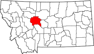
This is a list of the National Register of Historic Places listings in Gallatin County, Montana.

<span class="mw-page-title-main">National Register of Historic Places listings in Lewis and Clark County, Montana</span>

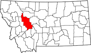
This is a list of the National Register of Historic Places listings in Lewis and Clark County, Montana.

<span class="mw-page-title-main">National Register of Historic Places listings in Sanders County, Montana</span>

This is a list of the National Register of Historic Places listings in Sanders County, Montana. It is intended to be a complete list of the properties and districts on the National Register of Historic Places in Sanders County, Montana, United States. The locations of National Register properties and districts for which the latitude and longitude coordinates are included below, may be seen in a map.

<span class="mw-page-title-main">National Register of Historic Places listings in Park County, Montana</span>

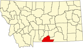
This is a list of the National Register of Historic Places listings in Park County, Montana.

<span class="mw-page-title-main">National Register of Historic Places listings in Glacier County, Montana</span>

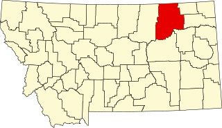
This is a list of the National Register of Historic Places listings in Glacier County, Montana. It is intended to be a complete list of the properties and districts on the National Register of Historic Places in Glacier County, Montana, United States. The locations of National Register properties and districts for which the latitude and longitude coordinates are included below, may be seen in a map.

<span class="mw-page-title-main">National Register of Historic Places listings in Rosebud County, Montana</span>

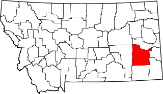
This is a list of the National Register of Historic Places listings in Rosebud County, Montana. It is intended to be a complete list of the properties and districts on the National Register of Historic Places in Rosebud County, Montana, United States. The locations of National Register properties and districts for which the latitude and longitude coordinates are included below, may be seen in a map.

<span class="mw-page-title-main">National Register of Historic Places listings in Beaverhead County, Montana</span>

This is a list of the National Register of Historic Places listings in Beaverhead County, Montana. It is intended to be a complete list of the properties and districts on the National Register of Historic Places in Beaverhead County, Montana, United States. The locations of National Register properties and districts for which the latitude and longitude coordinates are included below, may be seen in a map.

<span class="mw-page-title-main">National Register of Historic Places listings in Silver Bow County, Montana</span>

This is a list of the National Register of Historic Places listings in Silver Bow County, Montana. It is intended to be a complete list of the properties and districts on the National Register of Historic Places in Silver Bow County, Montana, United States. The locations of National Register properties and districts for which the latitude and longitude coordinates are included below, may be seen in a map.

<span class="mw-page-title-main">National Register of Historic Places listings in Madison County, Montana</span>

This is a list of the National Register of Historic Places listings in Madison County, Montana. It is intended to be a complete list of the properties and districts on the National Register of Historic Places in Madison County, Montana, United States. The locations of National Register properties and districts for which the latitude and longitude coordinates are included below, may be seen in a map.

<span class="mw-page-title-main">National Register of Historic Places listings in Dawson County, Montana</span>

This is a list of the National Register of Historic Places listings in Dawson County, Montana. It is intended to be a complete list of the properties and districts on the National Register of Historic Places in Dawson County, Montana, United States. The locations of National Register properties and districts for which the latitude and longitude coordinates are included below, may be seen in a map.

<span class="mw-page-title-main">National Register of Historic Places listings in Custer County, Montana</span>

This is a list of the National Register of Historic Places listings in Custer County, Montana. It is intended to be a complete list of the properties and districts on the National Register of Historic Places in Custer County, Montana, United States. The locations of National Register properties and districts for which the latitude and longitude coordinates are included below, may be seen in a map.

<span class="mw-page-title-main">National Register of Historic Places listings in Granite County, Montana</span>

This is a list of the National Register of Historic Places listings in Granite County, Montana. It is intended to be a complete list of the properties and districts on the National Register of Historic Places in Granite County, Montana, United States. The locations of National Register properties and districts for which the latitude and longitude coordinates are included below, may be seen in a map.

<span class="mw-page-title-main">National Register of Historic Places listings in Powell County, Montana</span>

This is a list of the National Register of Historic Places listings in Powell County, Montana.

<span class="mw-page-title-main">National Register of Historic Places listings in Valley County, Montana</span>

This is a list of the National Register of Historic Places listings in Valley County, Montana. It is intended to be a complete list of the properties and districts on the National Register of Historic Places in Valley County, Montana, United States. The locations of National Register properties and districts for which the latitude and longitude coordinates are included below, may be seen in a map.

<span class="mw-page-title-main">National Register of Historic Places listings in Mineral County, West Virginia</span>

This is a list of the National Register of Historic Places listings in Mineral County, West Virginia.

<span class="mw-page-title-main">National Register of Historic Places listings in Lake County, Montana</span>

This is a list of the National Register of Historic Places listings in Lake County, Montana. It is intended to be a complete list of the properties and districts on the National Register of Historic Places in Lake County, Montana, United States. The locations of National Register properties and districts for which the latitude and longitude coordinates are included below, may be seen in a map.

<span class="mw-page-title-main">National Register of Historic Places listings in Jefferson County, Montana</span>

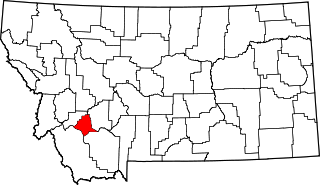
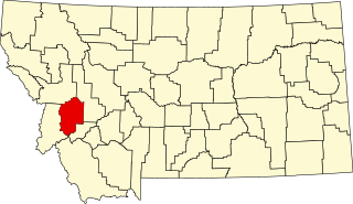
This is a list of the National Register of Historic Places listings in Jefferson County, Montana. It is intended to be a complete list of the properties and districts on the National Register of Historic Places in Jefferson County, Montana, United States. The locations of National Register properties and districts for which the latitude and longitude coordinates are included below, may be seen in a map.

<span class="mw-page-title-main">National Register of Historic Places listings in Stillwater County, Montana</span>

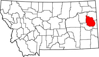
This is a list of the National Register of Historic Places listings in Stillwater County, Montana. It is intended to be a complete list of the properties and districts on the National Register of Historic Places in Stillwater County, Montana, United States. The locations of National Register properties and districts for which the latitude and longitude coordinates are included below, may be seen in a map.

References

  1. The latitude and longitude information provided in this table was derived originally from the National Register Information System, which has been found to be fairly accurate for about 99% of listings. Some locations in this table may have been corrected to current GPS standards.
  2. National Park Service, United States Department of the Interior, "National Register of Historic Places: Weekly List Actions", retrieved November 25, 2022.
  3. Numbers represent an alphabetical ordering by significant words. Various colorings, defined here, differentiate National Historic Landmarks and historic districts from other NRHP buildings, structures, sites or objects.
  4. The eight-digit number below each date is the number assigned to each location in the National Register Information System database, which can be viewed by clicking the number.