National Register of Historic Places listings in Silver Bow County, Montana

Last updated

Location of Silver Bow County in Montana Map of Montana highlighting Silver Bow County.svg
Location of Silver Bow County in Montana

This is a list of the National Register of Historic Places listings in Silver Bow County, Montana. It is intended to be a complete list of the properties and districts on the National Register of Historic Places in Silver Bow County, Montana, United States. The locations of National Register properties and districts for which the latitude and longitude coordinates are included below, may be seen in a map. [1]

Contents

There are 22 properties and districts listed on the National Register in the county, including 2 National Historic Landmarks.


    This National Park Service list is complete through NPS recent listings posted April 12, 2024. [2]

Listings county-wide

[3] Name on the RegisterImageDate listed [4] Location City or townDescription
1 Basin Creek Park Historic District November 27, 2023
(#100009566)
Approximately 9 miles (14 km) south of Butte on Basin Creek Rd. (393)
45°51′22″N112°32′45″W / 45.8560°N 112.5459°W / 45.8560; -112.5459 (Basin Creek Park Historic District)
Butte vicinity
2 Big Hole Pumpstation
Big Hole Pumpstation Big Hole Pumpstation.jpg
Big Hole Pumpstation
September 24, 1980
(#80002432)
Montana Highway 43
45°45′50″N112°47′14″W / 45.763889°N 112.787222°W / 45.763889; -112.787222 (Big Hole Pumpstation)
Butte
3 Butte, Anaconda and Pacific Railway Historic District
Butte, Anaconda and Pacific Railway Historic District ButteMT ButteAnacondaAndPacificRailwayHD2.jpg
Butte, Anaconda and Pacific Railway Historic District
October 13, 1988
(#88001111)
Right-of-way begins in Butte and travels to Anaconda, generally along the course of Silver Bow Creek; also the confluence of German Gulch and Silver Bow Creeks at the eastern end of Silver Bow Canyon
46°02′37″N112°44′25″W / 46.043611°N 112.740278°W / 46.043611; -112.740278 (Butte, Anaconda and Pacific Railway Historic District)
Butte Extends into Deer Lodge County. Location at the confluence represents a boundary increase, added on January 13, 1989
4 Butte-Anaconda Historic District
Butte-Anaconda Historic District Butteview.jpg
Butte-Anaconda Historic District
October 15, 1966
(#66000438)
Most of the developed areas of Anaconda, Butte, and Walkerville
46°00′55″N112°32′10″W / 46.015278°N 112.536111°W / 46.015278; -112.536111 (Butte-Anaconda Historic District)
Butte and Walkerville Extends into Deer Lodge County
5 Charles W. Clark Mansion
Charles W. Clark Mansion Charles W Clark Mansion (2013) - Silver Bow County, Montana.png
Charles W. Clark Mansion
October 22, 1976
(#76001128)
108 N. Washington St.
46°00′49″N112°32′28″W / 46.013611°N 112.541111°W / 46.013611; -112.541111 (Charles W. Clark Mansion)
Butte
6 W. A. Clark Mansion
W. A. Clark Mansion Copper King Mansion (Butte) 2002-05.jpg
W. A. Clark Mansion
October 6, 1970
(#70000366)
219 W. Granite
46°00′52″N112°32′21″W / 46.014444°N 112.539167°W / 46.014444; -112.539167 (W. A. Clark Mansion)
Butte
7 Harding Way Historic District April 8, 2024
(#100010219)
MP 75.0 to Milepost 80.1
Coordinates missing
Butte vicinity
8 Hawthorne Grade School
Hawthorne Grade School Hawthorne Grade School Butte.JPG
Hawthorne Grade School
January 25, 1988
(#87002304)
3500 White Way
45°58′28″N112°29′16″W / 45.974444°N 112.487778°W / 45.974444; -112.487778 (Hawthorne Grade School)
Butte
9 Homestake Airway Beacon May 31, 2019
(#100004037)
Along Continental Divide at Homestake Pass in Beaverhead-Deerlodge National Forest
45°55′11″N112°25′00″W / 45.9196°N 112.4167°W / 45.9196; -112.4167 (Homestake Airway Beacon)
Butte vicinityExtends into Jefferson County.
10 Longfellow Grade School January 25, 1988
(#87002305)
1629 Roosevelt Ave.
45°58′47″N112°30′54″W / 45.979722°N 112.515°W / 45.979722; -112.515 (Longfellow Grade School)
Butte Demolished in 2007
11 Madison Grade School
Madison Grade School Madison Grade School (2013) - Silver Bow County, Montana.png
Madison Grade School
January 25, 1988
(#87002306)
45 E. Greenwood
45°59′24″N112°32′06″W / 45.99°N 112.535°W / 45.99; -112.535 (Madison Grade School)
Butte
12 Matt's Place Drive-In
Matt's Place Drive-In Matt's Place Drive-In (2013) - Silver Bow County, Montana.png
Matt's Place Drive-In
March 29, 2001
(#01000308)
2339 Placer St.
45°59′30″N112°32′18″W / 45.991667°N 112.538333°W / 45.991667; -112.538333 (Matt's Place Drive-In)
Butte
13 Parrot Mine Shops Complex
Parrot Mine Shops Complex Parrot Mine Shops Complex (2013) - Silver Bow County, Montana.png
Parrot Mine Shops Complex
January 9, 2007
(#06001228)
244 Anaconda Rd.
46°01′01″N112°31′41″W / 46.016944°N 112.528056°W / 46.016944; -112.528056 (Parrot Mine Shops Complex)
Butte
14 Ramsay Historic District
Ramsay Historic District RamsayMT RamsayHD4.jpg
Ramsay Historic District
January 14, 1988
(#87002227)
6.5 miles west of Butte on Interstate 90
46°00′20″N112°41′09″W / 46.005556°N 112.685833°W / 46.005556; -112.685833 (Ramsay Historic District)
Butte
15 Shaffer's Chapel African Methodist Episcopal Church December 3, 2018
(#100003199)
602 S Idaho
46°00′24″N112°32′25″W / 46.0067°N 112.5404°W / 46.0067; -112.5404 (Shaffer's Chapel African Methodist Episcopal Church)
Butte
16 Silver Bow Airway Beacon May 25, 2019
(#100004023)
Approximately 3 miles northwest of Ramsay
46°03′06″N112°42′45″W / 46.0518°N 112.7124°W / 46.0518; -112.7124 (Silver Bow Airway Beacon)
Ramsay vicinity
17 Silver Bow Brewery Malt House
Silver Bow Brewery Malt House ButteMT SilverBowBreweryMaltHouse.jpg
Silver Bow Brewery Malt House
January 19, 1983
(#83001076)
West of Butte off U.S. Route 91
46°00′22″N112°38′35″W / 46.006111°N 112.643056°W / 46.006111; -112.643056 (Silver Bow Brewery Malt House)
Butte
18 Silver Bow County Poor Farm Hospital
Silver Bow County Poor Farm Hospital Silver Bow County Poor Farm Hospital 02.jpg
Silver Bow County Poor Farm Hospital
July 16, 1981
(#81000366)
3040 Continental Dr.
45°59′04″N112°29′09″W / 45.984444°N 112.485833°W / 45.984444; -112.485833 (Silver Bow County Poor Farm Hospital)
Butte
19 Socialist Hall
Socialist Hall Socialisthall.jpg
Socialist Hall
May 26, 1995
(#95000661)
1957 Harrison Ave.
45°59′39″N112°30′45″W / 45.994167°N 112.5125°W / 45.994167; -112.5125 (Socialist Hall)
Butte
20 U.S. Post Office
U.S. Post Office Mansfield Fed Courthouse.JPG
U.S. Post Office
November 15, 1979
(#79001426)
400 N. Main St
46°00′52″N112°32′19″W / 46.014444°N 112.538611°W / 46.014444; -112.538611 (U.S. Post Office)
Butte
21 Burton K. Wheeler House
Burton K. Wheeler House Burton K. Wheeler House (2013) - Silver Bow County, Montana.png
Burton K. Wheeler House
December 8, 1976
(#76001129)
1232 E. 2nd St.
46°00′20″N112°31′13″W / 46.005556°N 112.520278°W / 46.005556; -112.520278 (Burton K. Wheeler House)
Butte
22 Wold Barn January 8, 2009
(#08001287)
Southwestern corner of the junction of Hecla and 3rd Sts.
45°37′50″N112°41′14″W / 45.630494°N 112.687244°W / 45.630494; -112.687244 (Wold Barn)
Melrose Barn from 1906.

See also

Related Research Articles

<span class="mw-page-title-main">National Register of Historic Places listings in Montana</span>

This is a list of properties and historic districts in Montana that are listed on the National Register of Historic Places. The state's more than 1,100 listings are distributed across all of its 56 counties.

<span class="mw-page-title-main">National Register of Historic Places listings in Big Horn County, Montana</span>

This is a list of the National Register of Historic Places listings in Big Horn County, Montana. It is intended to be a complete list of the properties and districts on the National Register of Historic Places in Big Horn County, Montana, United States. The locations of National Register properties and districts for which the latitude and longitude coordinates are included below, may be seen in a map.

<span class="mw-page-title-main">National Register of Historic Places listings in Cascade County, Montana</span>

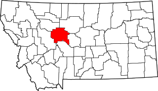
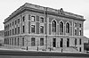
This is a list of the National Register of Historic Places listings in Cascade County, Montana. It is intended to be a complete list of the properties and districts on the National Register of Historic Places in Cascade County, Montana, United States. The locations of National Register properties and districts for which the latitude and longitude coordinates are included below, may be seen in a map.

<span class="mw-page-title-main">National Register of Historic Places listings in Carbon County, Montana</span>

This is a list of the National Register of Historic Places listings in Carbon County, Montana.

<span class="mw-page-title-main">National Register of Historic Places listings in Flathead County, Montana</span>

This is a list of the National Register of Historic Places listings in Flathead County, Montana.

<span class="mw-page-title-main">National Register of Historic Places listings in Gallatin County, Montana</span>

This is a list of the National Register of Historic Places listings in Gallatin County, Montana.

<span class="mw-page-title-main">National Register of Historic Places listings in Sanders County, Montana</span>

This is a list of the National Register of Historic Places listings in Sanders County, Montana. It is intended to be a complete list of the properties and districts on the National Register of Historic Places in Sanders County, Montana, United States. The locations of National Register properties and districts for which the latitude and longitude coordinates are included below, may be seen in a map.

<span class="mw-page-title-main">National Register of Historic Places listings in Park County, Montana</span>

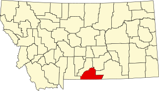
This is a list of the National Register of Historic Places listings in Park County, Montana.

<span class="mw-page-title-main">National Register of Historic Places listings in Glacier County, Montana</span>

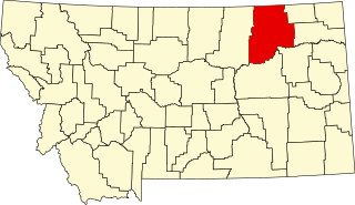
This is a list of the National Register of Historic Places listings in Glacier County, Montana. It is intended to be a complete list of the properties and districts on the National Register of Historic Places in Glacier County, Montana, United States. The locations of National Register properties and districts for which the latitude and longitude coordinates are included below, may be seen in a map.

<span class="mw-page-title-main">National Register of Historic Places listings in Rosebud County, Montana</span>

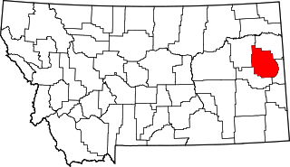
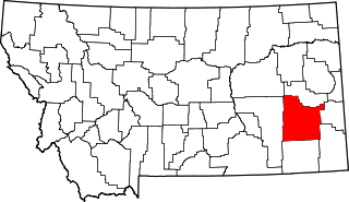
This is a list of the National Register of Historic Places listings in Rosebud County, Montana. It is intended to be a complete list of the properties and districts on the National Register of Historic Places in Rosebud County, Montana, United States. The locations of National Register properties and districts for which the latitude and longitude coordinates are included below, may be seen in a map.

<span class="mw-page-title-main">National Register of Historic Places listings in Beaverhead County, Montana</span>

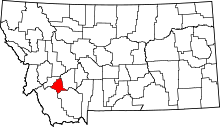
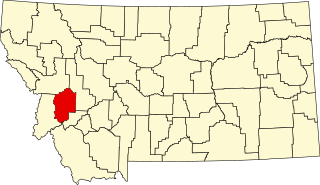
This is a list of the National Register of Historic Places listings in Beaverhead County, Montana. It is intended to be a complete list of the properties and districts on the National Register of Historic Places in Beaverhead County, Montana, United States. The locations of National Register properties and districts for which the latitude and longitude coordinates are included below, may be seen in a map.

<span class="mw-page-title-main">National Register of Historic Places listings in Madison County, Montana</span>

This is a list of the National Register of Historic Places listings in Madison County, Montana. It is intended to be a complete list of the properties and districts on the National Register of Historic Places in Madison County, Montana, United States. The locations of National Register properties and districts for which the latitude and longitude coordinates are included below, may be seen in a map.

<span class="mw-page-title-main">National Register of Historic Places listings in Dawson County, Montana</span>

This is a list of the National Register of Historic Places listings in Dawson County, Montana. It is intended to be a complete list of the properties and districts on the National Register of Historic Places in Dawson County, Montana, United States. The locations of National Register properties and districts for which the latitude and longitude coordinates are included below, may be seen in a map.

<span class="mw-page-title-main">National Register of Historic Places listings in Custer County, Montana</span>

This is a list of the National Register of Historic Places listings in Custer County, Montana. It is intended to be a complete list of the properties and districts on the National Register of Historic Places in Custer County, Montana, United States. The locations of National Register properties and districts for which the latitude and longitude coordinates are included below, may be seen in a map.

<span class="mw-page-title-main">National Register of Historic Places listings in Mineral County, Montana</span>

This is a list of the National Register of Historic Places listings in Mineral County, Montana.

<span class="mw-page-title-main">National Register of Historic Places listings in Granite County, Montana</span>

This is a list of the National Register of Historic Places listings in Granite County, Montana. It is intended to be a complete list of the properties and districts on the National Register of Historic Places in Granite County, Montana, United States. The locations of National Register properties and districts for which the latitude and longitude coordinates are included below, may be seen in a map.

<span class="mw-page-title-main">National Register of Historic Places listings in Powell County, Montana</span>

This is a list of the National Register of Historic Places listings in Powell County, Montana.

<span class="mw-page-title-main">National Register of Historic Places listings in Valley County, Montana</span>

This is a list of the National Register of Historic Places listings in Valley County, Montana. It is intended to be a complete list of the properties and districts on the National Register of Historic Places in Valley County, Montana, United States. The locations of National Register properties and districts for which the latitude and longitude coordinates are included below, may be seen in a map.

<span class="mw-page-title-main">National Register of Historic Places listings in Jefferson County, Montana</span>

This is a list of the National Register of Historic Places listings in Jefferson County, Montana. It is intended to be a complete list of the properties and districts on the National Register of Historic Places in Jefferson County, Montana, United States. The locations of National Register properties and districts for which the latitude and longitude coordinates are included below, may be seen in a map.

<span class="mw-page-title-main">National Register of Historic Places listings in Stillwater County, Montana</span>

This is a list of the National Register of Historic Places listings in Stillwater County, Montana. It is intended to be a complete list of the properties and districts on the National Register of Historic Places in Stillwater County, Montana, United States. The locations of National Register properties and districts for which the latitude and longitude coordinates are included below, may be seen in a map.

References

  1. The latitude and longitude information provided in this table was derived originally from the National Register Information System, which has been found to be fairly accurate for about 99% of listings. Some locations in this table may have been corrected to current GPS standards.
  2. National Park Service, United States Department of the Interior, "National Register of Historic Places: Weekly List Actions", retrieved April 12, 2024.
  3. Numbers represent an alphabetical ordering by significant words. Various colorings, defined here, differentiate National Historic Landmarks and historic districts from other NRHP buildings, structures, sites or objects.
  4. The eight-digit number below each date is the number assigned to each location in the National Register Information System database, which can be viewed by clicking the number.