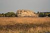
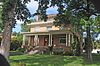
This is a list of properties and historic districts in Montana that are listed on the National Register of Historic Places. The state's more than 1,100 listings are distributed across all of its 56 counties.
This is a list of the National Register of Historic Places listings in Cascade County, Montana. It is intended to be a complete list of the properties and districts on the National Register of Historic Places in Cascade County, Montana, United States. The locations of National Register properties and districts for which the latitude and longitude coordinates are included below, may be seen in a map.
This is a list of the National Register of Historic Places listings in Carbon County, Montana.

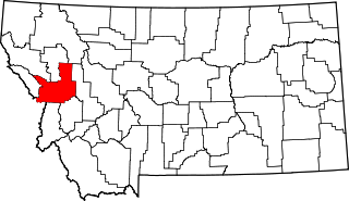
This is a list of the National Register of Historic Places listings in Deer Lodge County, Montana. It is intended to be a complete list of the properties and districts on the National Register of Historic Places in Deer Lodge County, Montana, United States. All sites are located in the city of Anaconda, which is consolidated with Deer Lodge County. The locations of National Register properties and districts for which the latitude and longitude coordinates are included below, may be seen in a map.

This is a list of the National Register of Historic Places listings in Gallatin County, Montana.
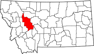
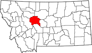
This is a list of the National Register of Historic Places listings in Lewis and Clark County, Montana.
This is a list of the National Register of Historic Places listings in Missoula County, Montana. It is intended to be a complete list of the properties and districts on the National Register of Historic Places in Missoula County, Montana, United States. The locations of National Register properties and districts for which the latitude and longitude coordinates are included below, may be seen in a map.

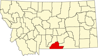
This is a list of the National Register of Historic Places listings in Park County, Montana.

This is a list of the National Register of Historic Places listings in Glacier County, Montana. It is intended to be a complete list of the properties and districts on the National Register of Historic Places in Glacier County, Montana, United States. The locations of National Register properties and districts for which the latitude and longitude coordinates are included below, may be seen in a map.

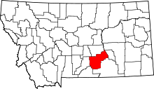
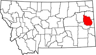
This is a list of the National Register of Historic Places listings in Rosebud County, Montana. It is intended to be a complete list of the properties and districts on the National Register of Historic Places in Rosebud County, Montana, United States. The locations of National Register properties and districts for which the latitude and longitude coordinates are included below, may be seen in a map.

This is a list of the National Register of Historic Places listings in Chouteau County, Montana. It is intended to be a complete list of the properties and districts on the National Register of Historic Places in Chouteau County, Montana, United States. The locations of National Register properties and districts for which the latitude and longitude coordinates are included below, may be seen in a map.

This is a list of the National Register of Historic Places listings in Beaverhead County, Montana. It is intended to be a complete list of the properties and districts on the National Register of Historic Places in Beaverhead County, Montana, United States. The locations of National Register properties and districts for which the latitude and longitude coordinates are included below, may be seen in a map.
This is a list of the National Register of Historic Places listings in Silver Bow County, Montana. It is intended to be a complete list of the properties and districts on the National Register of Historic Places in Silver Bow County, Montana, United States. The locations of National Register properties and districts for which the latitude and longitude coordinates are included below, may be seen in a map.
This is a list of the National Register of Historic Places listings in Dawson County, Montana. It is intended to be a complete list of the properties and districts on the National Register of Historic Places in Dawson County, Montana, United States. The locations of National Register properties and districts for which the latitude and longitude coordinates are included below, may be seen in a map.

This is a list of the National Register of Historic Places listings in Mineral County, Montana.

This is a list of the National Register of Historic Places listings in Brown County, South Dakota.

This is a list of the National Register of Historic Places listings in Lake County, Montana. It is intended to be a complete list of the properties and districts on the National Register of Historic Places in Lake County, Montana, United States. The locations of National Register properties and districts for which the latitude and longitude coordinates are included below, may be seen in a map.

This is a list of the National Register of Historic Places listings in Blaine County, Montana. It is intended to be a complete list of the properties and districts on the National Register of Historic Places in Blaine County, Montana, United States. The locations of National Register properties and districts for which the latitude and longitude coordinates are included below, may be seen in a map.
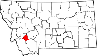
This is a list of the National Register of Historic Places listings in Jefferson County, Montana. It is intended to be a complete list of the properties and districts on the National Register of Historic Places in Jefferson County, Montana, United States. The locations of National Register properties and districts for which the latitude and longitude coordinates are included below, may be seen in a map.

This is a list of the National Register of Historic Places listings in Armstrong County, Texas.