Sources
Municipalities and communities of Yellowstone County, Montana, United States | ||
|---|---|---|
| Cities |  | |
| Town | ||
| CDPs | ||
| Other unincorporated communities | ||
| Indian reservation | ||
| Ghost town | ||
| Footnotes | ‡This populated place also has portions in an adjacent county or counties | |
Rimrock is a populated place located in Yellowstone County, Montana, United States at 45°48′07″N108°42′11″W / 45.802°N 108.703°W Coordinates: 45°48′07″N108°42′11″W / 45.802°N 108.703°W .
The elevation is 3,468 feet. Rimrock appears on the Rimrock U.S. Geological Survey Map. Yellowstone County is in the Mountain Time Zone (UTC -7 hours).
Rimrock was established as a stop on the Great Northern Railroad and was named after a distinct sandstone cliff formation that it stood at the base of.
Today the area is closed to the public, including the 72nd Street West access. The area is primarily used for agriculture. Only a few trees and the now unused railroad siding and mound can be seen. There is little else at surface remaining. Much is hidden from ground view due to the high berm of the railroad, but the layout can be viewed from Philps Park, which occupies part of the cliff formations just above the site.
Municipalities and communities of Yellowstone County, Montana, United States | ||
|---|---|---|
| Cities | | |
| Town | ||
| CDPs | ||
| Other unincorporated communities | ||
| Indian reservation | ||
| Ghost town | ||
| Footnotes | ‡This populated place also has portions in an adjacent county or counties | |

Yellowstone County is the most populous county in the U.S. state of Montana. As of the 2010 United States Census, the population was 147,972, and a 2019 estimate put the population at 161,300. Its county seat is Billings. Yellowstone County is named for the Yellowstone River which roughly bisects the county, flowing southwest to northeast. The river in turn was named after the yellow Sandstone cliffs in what is now Yellowstone County.

West Yellowstone is a town in Gallatin County, Montana, United States, adjacent to Yellowstone National Park. The population was 1,271 at the 2010 census. West Yellowstone is served by Yellowstone Airport. It is part of the Bozeman, MT Micropolitan Statistical Area.
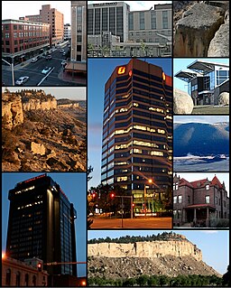
Billings is the largest city in the U.S. state of Montana, with a population estimated at 109,577 as of 2019. Located in the south-central portion of the state, it is the seat of Yellowstone County and the principal city of the Billings Metropolitan Area, which had an estimated population of 180,385 in 2018. It has a trade area of over 500,000.

Huntley is a census-designated place (CDP) in Yellowstone County, Montana, United States. The population was 411 at the 2000 census. Huntley lent its name to the Huntley Project, a federal irrigation project that began delivering water to the arid district in 1907. Today, Huntley is an eastern suburb of Billings and is located east of Shepherd and west of Worden.

Rimrock is the sheer rock wall at the upper edge of a plateau, canyon, or geological uplift. It may refer to either the rock formation or to the rock itself. Rimrock may be composed of almost any stone—basalt, gneiss, granite, sandstone, etc.—and is frequently layered. Many times it overlays a softer stone which erodes away underneath. American Indians in the West often used cavities found below rimrock to construct dwellings and granaries.

MetraPark Arena, currently known as First Interstate Arena due to sponsorship, and colloquially known as The Metra, is a multi-purpose arena located at MetraPark, the fairgrounds of Billings, Montana, USA. The arena has capacity for an audience of 12,000. The arena hosts a variety of local sporting, musical, and other events. It has also hosted professional sporting competitions. In 2005, MetraPark Arena marked its 30th anniversary. The arena was renovated in 2010 and 2011 at a cost of $27 million.

The Billings Metropolitan Statistical Area is the largest and fastest growing metropolitan area in the U.S. state of Montana. Located in the south central portion of the state, its population was estimated at 180,385 in 2018.
Rimrock Mall is an indoor shopping mall located in Billings, Montana. It is managed by Starwood Capital Group. The mall is anchored by two Dillard's stores and J. C. Penney.

The Washburn Expedition of 1870 explored the region of northwestern Wyoming that two years later became Yellowstone National Park. Led by Henry Washburn and Nathaniel P. Langford, and with a U.S. Army escort headed by Lt. Gustavus C. Doane, the expedition followed the general course of the Cook–Folsom–Peterson Expedition made the previous year.

The Rimrocks are geological rimrock sandstone formations that outcrop in sections of Billings, Montana.

Acton is an unincorporated community in northwestern Yellowstone County, Montana, United States. It has a postal ZIP code (59002) and lies along Montana Highway 3 northwest of the city of Billings, the county seat of Yellowstone County. Its elevation is 3,802 feet (1,159 m), and it is located at coordinates |45|55|50|N|108|40|51|W|

The 2010 Father's Day tornado was an EF2 tornado that hit Billings, Montana on Sunday June 20, 2010. The tornado was on the ground for about 15 minutes and took the roof off the Rimrock Auto Arena at MetraPark, a 10,000 seat arena, and heavily damaged numerous businesses. The storm was accompanied by high winds and a major hail storm that caused severe damage and flash flooding in the Heights section of the city. It was the first time since 1958 that a significant tornado struck the downtown Billings area.
The following is a timeline of the history of the city of Billings, Montana, USA.