Related Research Articles

Walter Burley Griffin was an American architect and landscape architect. He is known for designing Canberra, Australia's capital city and the New South Wales towns of Griffith and Leeton. He has been credited with the development of the L-shaped floor plan, the carport and an innovative use of reinforced concrete.

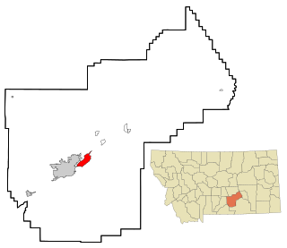
Ballantine is a census-designated place (CDP) in Yellowstone County, Montana, United States. It lies approximately nine miles (10 km) northeast of Billings on Interstate 94. The population was 346 at the 2000 census. Ballantine, along with the communities of Pompey's Pillar, Worden, and Huntley, is part of the Huntley Project, an irrigation district created by the United States Bureau of Reclamation. The majority of Ballantine's population lives on scattered farms and ranches surrounding the actual townsite.
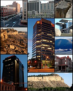
Billings is the largest city in the U.S. state of Montana, with a population estimated at 109,577 as of 2019. Located in the south-central portion of the state, it is the seat of Yellowstone County and the principal city of the Billings Metropolitan Area, which had an estimated population of 180,385 in 2018. It has a trade area of over 500,000.

Laurel is a city in Yellowstone County, Montana, United States. It is the third largest community in the Billings Metropolitan Statistical Area, and is located in the Yellowstone Valley, as an east–west terminal division point of the Burlington-Northern Railroad. The population was 6,781 at the 2010 census.
Lockwood is a census-designated place (CDP) in Yellowstone County, Montana, United States. Lockwood had the largest growth rate in the state of Montana with 57.8% growth since 2000. The 2010 census put Lockwood’s population at 6,797. Lockwood is a suburb of Billings and is the second largest community in the Billings Metropolitan Area. Annexation of Lockwood to Billings has been studied; however, the June 2009 Billings City Council Annexation Plan states that the city has no plans to annex Lockwood in the foreseeable future.

Castlecrag is a suburb on the lower North Shore of Sydney, in the state of New South Wales, Australia 8 kilometres north of the Sydney central business district, in the local government area of the City of Willoughby.
U.S. Route 212 (US 212) is a spur of U.S. Route 12. It runs for 949 miles (1,527 km) from Minnesota Highway 62 at Edina, Minnesota to Yellowstone National Park. It does not intersect U.S. 12 now, but it once had an eastern terminus at U.S. 12 in St. Paul, Minnesota.
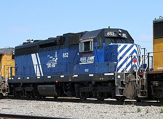
Montana Rail Link is a privately held Class II railroad in the United States. MRL, which operates on trackage originally built by the Northern Pacific Railway, is a unit of The Washington Companies, and is headquartered in Missoula, Montana.
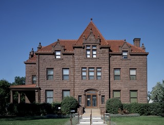
The Moss Mansion Historic House Museum is located at 914 Division Street in Billings, Montana, United States. It is a red-stoned mansion built in 1903 by Preston Boyd Moss and his wife, Martha Ursula Woodson Moss, (Mattie). Mr. and Mrs. Moss moved to Billings from Paris, Missouri where, "There was more happening at midnight than at noon in Paris Missouri"

The Billings Metropolitan Statistical Area is the largest and fastest growing metropolitan area in the U.S. state of Montana. Located in the south central portion of the state, its population was estimated at 180,385 in 2018.
Highway 59 (MT 59) is a 195.389-mile-long (314.448 km) state highway in the U.S. state of Montana is a route traveling northerly from the Wyoming state line to an intersection with MT 200 near the south end of the town of Jordan. At the Wyoming state line, the road becomes Wyoming Highway 59, which continues south 57 miles (92 km) to the city of Gillette. The landscape traversed by MT 59 is mostly hilly and arid, largely used for open-range grazing; the only major commercial areas are the towns of Broadus and Miles City.

Fred Fielding Willson, most commonly known as Fred F. Willson, was an architect in Bozeman, Montana who designed many buildings that are listed on the National Register of Historic Places.

Comanche is an unincorporated community in Yellowstone County, Montana, United States. It lies on Montana Highway 3, 16 miles northwest of the city of Billings and shares a postal ZIP code with Acton (59002). Comanche is at an elevation of 3,747 ft. ; its coordinates are 45|59|51|N|108|46|24|W
The following is a timeline of the history of the city of Billings, Montana, USA.

Transportation in Montana comprises many different forms of travel. Montana shares a long border with Canada, hence international crossings are prevalent in the northern section of the state; there are 13 road crossings and one rail crossing.

The Walter Burley Griffin Lodge is a heritage-listed former residence, holiday house and weekender and now residence located at 32 Plateau Road, Avalon Beach, Northern Beaches Council, New South Wales, Australia. It was designed by Walter Burley Griffin and built from 1933 to 1934. It is also known as Burley Griffin Lodge or Stella James House. The property is owned by the New South Wales branch of the National Trust of Australia. The property was added to the New South Wales State Heritage Register on 1 March 2002.

Redstone is a heritage-listed private house at 34 Adderton Road, Telopea, City of Parramatta, New South Wales, Australia. It was designed by Walter Burley Griffin and built in 1935. It is also known as The Winter House. It was added to the New South Wales State Heritage Register on 9 January 2009.

The Walter Burley Griffin Incinerator is a heritage-listed former incinerator and now art gallery, artists studios and public recreation area at 2 Small Street, Willoughby, City of Willoughby, Sydney, New South Wales, Australia. It was designed in partnership between Walter Burley Griffin and Eric Nicholls and built from 1933 to 1934 by Reverberatory Incinerator and Engineering Company and Nisson Leonard-Kanevsky. It is also known as Willoughby Municipal Incinerator. The property is owned by the Willoughby City Council. It was added to the New South Wales State Heritage Register on 2 April 1999.

The Fishwick House is a heritage-listed private residence located at 15 The Citadel, Castlecrag, City of Willoughby, New South Wales, Australia. It was designed by Walter Burley Griffin and Marion Mahony Griffin and built during 1929. It is also known as The Fishwick House and Fyshwick House. The property is privately owned. It was added to the New South Wales State Heritage Register on 15 December 2006.
References
- ↑ Great American Homes. Reader's Digest Association p. 78. 1997. ISBN 978-0-8957-7964-9.
- ↑ "Famous Montana faces — of hair". Independent Record . December 6, 2019. Retrieved February 20, 2021.
- ↑ Rogers, Rob (February 4, 2020). "Billings' Coulson Park could have amphitheater, bike track, dog park and more in its future". Billings Gazette . Retrieved February 20, 2021.
- ↑ Harrison, Peter (1995). Walter Burley Griffin, Landscape Architect. National Library of Australia p. 53. ISBN 978-0-6421-0644-5.
