Gaighat is an administrative centre within Triyuga Municipality and the headquarter of Udayapur District located in Province No. 1 of Nepal. Gaighat is divided into 2 wards called Gaighat Bazar and Old Gaighat. The Gaighat is located in Ward No. 11 and Old Gaighat is in Ward No. 12 of Triyuga Municipality. Total area of two wards is 16.11 square kilometres (6.22 sq mi) and total population is 14,243 with 2832 households.
Rangeli is a Municipality and rural market town in Morang District in the Koshi Zone of south-eastern Nepal. This municipality was formed merging existing four villages i.e.Amgachhi, Babiabirta, Darbesa and Rangeli itself since May 2014.

A village development committee in Nepal was the lower administrative part of its Ministry of Federal Affairs and Local Development. Each district had several VDCs, similar to municipalities but with greater public-government interaction and administration. There were 3,157 village development committees in Nepal. Each village development committee was further divided into several wards depending on the population of the district, the average being nine wards.
Taple (ताप्ले) was a village development committee in Gorkha District in the Gandaki Zone of northern-central Nepal. At the time of the 1991 Nepal census, it had a population of 4,398 and had 5000 houses in the town Hindu Muslim.
Mahadevsthan Mandan is a village development committee in Kavrepalanchok District in the Bagmati Zone of central Nepal.
Saudiyar is a town and Village Development Committee in Dang Deokhuri District in Lumbini Province of south-western Nepal. At the time of the 1991 Nepal census it had a population of 8,052 persons living in 1067 individual households.
Dhikurpokhari is a suburb and former Village Development Committee in Kaski District in the Gandaki Province of northern-central Nepal. At the time of the 1991 Nepal census it had a population of 7,392 persons living in 1,427 individual households.

Kakani is a Gaunpalika and former village development committee in Nuwakot District in Bagmati Province of central Nepal. At the time of the 1991 Nepal census, the Kakani village development committee administered a population of 7816 living in 1343 individual households.
Bajung is a village development committee in Parbat District in the Dhawalagiri Zone of Western Development Region, Nepal. It is surrounded by Deupurkot to the north-east, Tilahar to the south-east, Durlung to the south-west and Kyang to the north-west. It is popularly said to be extended from the top of Maidan, a hill-top with historical identity to the basin of Modi River. At the time of the 2011 Nepal census it had a population of 4228 people living in 1,076 individual households.
Parsa is a rural municipality in Sarlahi District, a part of Madhesh Province in Nepal. It is situated 10 km East from Malangwa which is headquarter of Sarlahi district. It was formed in 2016 occupying current 6 sections (wards) from previous 6 former VDCs. It occupies an area of 23.12 km2 with a total population of 21,650. The major language spoken in the rural municipality are Maithili and Bajjika.
Bahuntilpung is a Village lies in South-eastern Nepal, located in Sindhuli District of the Janakpur Zone. Among 11 wards of Tinpatan Rural Municipality it is ward no. 8. According to the 1991 Nepal census its population is 3,007.
Jhalariझलारी is a Village Development Committee in Kanchanpur District in Sudurpashchim Province of South-Far-Western Nepal. At the time of the 1991 Nepal census it had a population of 10,590 people living in 1702 individual households.

Katahariya is a municipality in Rautahat District in the Narayani Zone of south-eastern Nepal. Before September 2017, Katahariya was one of the Village Development Committees (VDC) with 8 wards. At the time of the 1991 Nepal census, it had a population of 4,619 people living in 835 individual households. Katahariya is famous for its unique moton dish. A well known moton dish named “Katiya : कटिया” is origin from Katahariya Bazar. It has a well-maintained Farmers' market (vegetable) and Cattle (domestic-animal) market. Katahariya is a fast-growing municipality, with the main occupations of local people being business and farming.
Pathari Shanishchare (पथरी-शनिश्चरे) is a Municipality in Morang District in the Koshi Zone of south-eastern Nepal. It was formed by merging three existing village development committees i.e. Hasandaha, Pathari and Sanischare in May 2014.
A gaunpalika is an administrative division in Nepal. The Ministry of Federal Affairs and Local Development dissolved the existing village development committees and announced the establishment of this new local body. It is a sub-unit of a district. There are currently 481 rural municipalities.

Local government in Nepal is the third level of government division in Nepal, which is administered by the provincial governments which in turn is beneath the federal government. Article 56 of the Constitution of Nepal 2015 defines local government as rural municipalities, municipalities and district assemblies.
Sundar Haraicha is a municipality in Morang District of Koshi Province in Nepal. It is centered around Biratchowk town which is the gateway to Biratnagar. It borders Itahari Sub- Metropolitan city to the west, Dharan Sub- Metropolitan city to the Northwest and Belbari municipality to the east and is connected by Mahendra Highway. It is one of the fastest growing cities in eastern Nepal and the second largest city of Morang district after Biratnagar, with 121,305 inhabitants living in 26,677 households. It consists of the town centres of Biratchowk and Gothgaun which are parts of the Greater Birat Development Area which incorporates the cities of Biratnagar-Itahari-Gothgau-Biratchowk-Dharan primarily located on the Koshi Highway in Eastern Nepal, with an estimated total urban agglomerated population of 804,300 people living in 159,332 households.

Tarakeshwar Rural Municipality is a Gaunpalika in Nuwakot District in Bagmati Province of central Nepal that was established in 11 March 2018 by merging the former Village Development Committees Khadga Bhanjyang(Ward no. 1 and 3), Gorsyang, Taruka and Dangsing. The headquarters of Tarkeshwor Gaupalika is located in Dangsing.
Mahashila Rural Municipality is a Gaunpalika in Parbat District in Gandaki of Nepal. On 12 March 2017, the government of Nepal implemented a new local administrative structure, with the implementation of the new local governance structure, Village Development Committees have been merged to form Municipalities and Gaunpalikas.
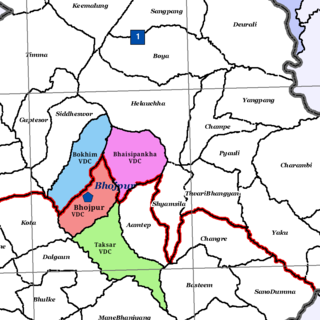
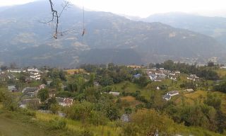
Bhojpur is a neighborhood in Bhojpur Municipality which is located in Bhojpur District in Province No. 1 of Nepal. The Bhojpur Village Panchayat was established in 1962 and was renamed Bhojpur Village Development Committee in 1990.
