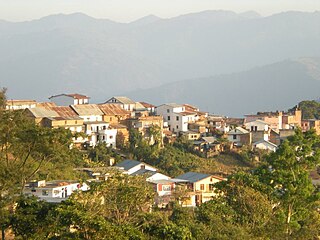
Dhankuta is a hill town and the headquarters of Dhankuta District in Koshi Province in Eastern Nepal. According to 2011 Nepal census, it has population of 26,440 inhabitants.

Dhangadhi is a sub-metropolitan city and the district headquarters of Kailali District in Sudurpashchim Province of Nepal. It shares a border with Uttar Pradesh, India in the south, Godawari and Gauriganga Municipality in the North, Kailari Rural Municipality in the east and Kanchanpur District in the west. Dhangadhi is a sub-metropolis divided into 19 wards. It has an area of 271.74 Sq. KM. It is one of the major cities of Far - West Province of Nepal along with Mahendranagar. The city is connected with the Mahakali Highway, about 750 kilometers west of Kathmandu, the capital of Nepal and connected with bordering market of Gauriphanta in the Indian state of Uttar Pradesh.
Kanchanpur District, a part of Sudurpashchim Province in the Terai plain, is one of seventy seven districts of Nepal. The district, with Bhimdatta as its district headquarters, covers an area of 1,610 square kilometres (620 sq mi) and had a population of 134,868 in 2001 and 171,304 in 2011. It is located in south-western of Nepal. It is bordered by Kailali district in the east, Dadeldhura district in the north and with India in the south and west.

Lamjung District, a part of Gandaki Province, is one of the 77 districts of Nepal. The district, with Besisahar as its district headquarters, covers an area of 1,692 square kilometres (653 sq mi) and as of 2011 had a population of 167,724. Lamjung lies in the mid-hills of Nepal spanning tropical to trans-Himalayan geo-ecological belts, including the geographical midpoint of the country. It has mixed habitation of casts and ethnicities. It is host to probably the highest density of the Gurung ethnic population in the country.
Mahottari District, a part of Madhesh Province, is one of the seventy-seven districts of Nepal. The district, with Jaleshwar as its district headquarter, covers an area of 1,002 km2 (387 sq mi) and had a population of 553,481 in 2001, 627,580 in 2011 and 705,838 in 2021 census. Its headquarters is located in Jaleshwar, a neighbouring town of the historical city of Janakpur. The name Jaleshwar means the 'God in Water'. One can find a famous temple of Lord Shiva in Water there. Jaleshwar lies at a few kilometres distance from the Nepal-India border and has a majority Maithili population.
Makwanpur District(Nepali: मकवानपुर जिल्ला;, in Bagmati Province, earlier a part of Narayani Zone, is one of the seventy-seven districts of Nepal. The city of Hetauda serves as the district headquarters and also as the provincial headquarters. The district covers an area of 2,426 km2 and had a population of 392,604 in 2001 and 420,477 in 2011. The latest census of 2021 recorded the population of Makwanpur as 466,073.

Morang District is located in Koshi Province in eastern Nepal. It is an Outer Terai district, which borders Jhapa to the east, Dhankuta and Panchthar to the north, Sunsari to the west, and Bihar, India, to the south. Morang has one metropolitan city (Biratnagar), eight municipalities and eight rural municipalities. The total area of the district is 1,855 km2 (716 sq mi). The lowest elevation point is 60 meters and the highest is 2,410 meters above sea level. The headquarters of Morang is connected by the Koshi National Highway to the east–west Mahendra National Highway at Itahari, Sunsari. Morang is also connected to the Hill parts of the eastern region of Nepal. Morang is the core industrial sector for the eastern region of Nepal.

Rautahat District, a part of Madhesh Province, is one of the seventy-seven districts of Nepal. The district headquarter is Gaur, including municipalities like Garuda, Chandrapur, Paroha, covers an area of 1,126 km2 and had a population of 545,132 in 2001 and 686,722 in 2011. This district has a total of 2 VDCs and 16 municipalities. Among other districts, Rautahat has the largest percent of Muslims in Nepal, about 19.7%. The most Muslim densely village Bairiya बैरिया but Majority of people in the District follow Hinduism. Sri Ram Sugar Mill is the only sugar mill located in Garuda municipality. The well known shiva temple located in Shivnagar, which is looked after by Sah and Jha family. The historical temple of Goddess Durga is in Matsari.Every year, the temple welcomes millions of devotees from different parts of Nepal and India as well on the occasion of Navaratri. Late Shri Gulab Narayan Jha, the first person to represent Madhesis in politics, was permanent resident of this village. There is a place called Najarpur in Chandrapur where whole village is vegetarian. They are not even allowed to buy or sell any alcoholic beverages and buying and selling of tobacco products is also prohibited.
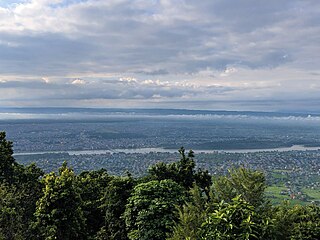
Bharatpur is a city in south central Nepal. It is the third most populous city of Nepal after Kathmandu and Pokhara with 369,377 inhabitants in 2021. It is also the second largest metropolitan city in Nepal by area. It is the district headquarter of the Chitwan District.
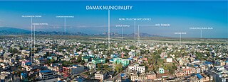
Damak, a city in eastern Nepal, is one of the oldest municipalities in Jhapa District in Koshi Province in eastern Nepal. It is situated between the Ratuwa River in the east and the Maawa River in the west. It has Sivalik Hills in its north and ends with the intersection of Ratuwa River and Maawa River in the south. Mahendra Highway, the longest highway of Nepal, bisects the municipality. It is the largest city in Jhapa District with a population of 107,410 in 2021.

Khandbari is the district headquarters of Sankhuwasabha District in Koshi Province of north-eastern Nepal.
Ratnanagar is a municipality in Chitwan District of Bagmati Province in Nepal. It is the second biggest municipality after Bharatpur Metropolitan City that was formed in 1997 through the merger of the former Village Development Committees Old-Ratnanagar and Panchakanya. It is adjacent to Chitwan National Park, and serves as a gateway to the park. Agricultural products produced from Ratnanagar includes rice, maize, mustard and vegetables. This municipality is also a major place for production of poultry products and animal husbandry. Tourism is another source of income generation for the people in Ratnanagar. People are directly or indirectly dependent in tourism industry. Ratnanagar is also concerned in environment preservation so in order to preserve and protect environment, eco-friendly electric risk-shaw has also been introduced and available in different parts of this municipality. It lies on the bank of East Rapti River.

Dipayal Silgadhi is a municipality and the district headquarters of Doti District in Sudurpashchim Province of Nepal. Previously, it also served as the headquarters of the Far-Western Development Region. It lies in the Lesser Himalayas on the bank of Seti River. At the time of the 2011 Nepal census it had a population of 32,941 people living in 7,447 individual households.

Manthali is a municipality and the headquarters of Ramechhap District in Bagmati Province, Nepal that was established on 2 December 2014 by merging the former village development committees Old-Manthali, Bhatauli, Chisapani, Kathjor, Bhaluwajor, Salupati and Sunarpani. It was declared the headquarters of the district on 9 March 1989. It lies on the bank of the Tamakoshi River. At the time of the 2011 Nepal census, it had a population of 45,416 people, living in 10,099 individual households.
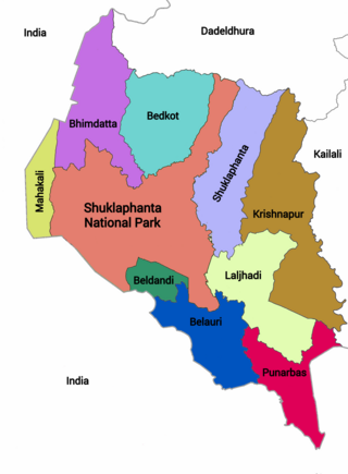
Punarwas is a Municipality in Kanchanpur District in Sudurpashchim Province of south-western Nepal. The new Municipality was established on 18 May 2014 by merging the existing 3 Village Development Committees i.e. Parasan, Tribhuwanbasti and Kalika. At the time of the 2011 Nepal census, it had a population of 43,996 people living in Punarwas.
Godawari is a municipality in Lalitpur District in Bagmati Province of Nepal. It was established on 2 December 2014 by merging the former Village development committees Godawari, Badikhel, Bisankhunarayan, Godamchaur and Thaiba of Lalitpur District of Bagmati Zone. The municipality area was again expanded in March 2017 to include in total 12 previous VDCs. The six VDCs added were Devichaur, Dukuchhap, Chhampi, Thecho, Chapagaun, Jharuwarasi and Lele. The centre of this municipality is located at Bajrabarahi.
Khairahani is a municipality in Chitwan District in Bagmati Province of southern Nepal. The municipality was established on 8 May 2014 by merging the existing Khairahani, Kumroj and Chainpur VDCs. At the time of the 1991 Nepal census it had a population of 13,629 people living in 2262 households.
Kalika is a municipality in Chitwan District in the Narayani Zone of southern Nepal. This municipality was established in 2015 AD by merging the existing Jutpani, Padampur, Shaktikhor and Siddhi VDCs.
Rapti Municipality is a municipality which lies in Eastern part of Chitwan district in Bagmati Province of Nepal. It was formed as municipality in 2015 by merging five existing village development committees, Birendranagar VDC, Bhandara VDC, Piple VDC, Lothar VDC and Korak VDC. Total area of this municipality is 99.40 and population of this municipality according to 2068 BS census is 46510.
Ichchhakamna is an only rural council located in Chitwan District in Bagmati Province of Nepal.


