Sawyers Bar, California

Last updated

Sawyers Bar
William H. Knowles, Photographer June, 1937 VIEW FROM SOUTHEAST - Store Buildings, Sawyers Bar, Siskiyou County, CA HABS CAL,47-SAWBA,1-1.tif
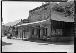
Store buildings in Sawyers Bar, 1937
California Locator Map with US.PNG
Red pog.svg
Sawyers Bar
Location in California
Usa edcp location map.svg
Red pog.svg
Sawyers Bar
Sawyers Bar (the United States)
Coordinates: 41°17′50.64″N123°7′49.08″W / 41.2974000°N 123.1303000°W / 41.2974000; -123.1303000
Country United States
State California
County Siskiyou County
Established1851
Elevation
[1]
2,247 ft (685 m)

Sawyers Bar is an unincorporated community located on the North Fork Salmon River in unincorporated Siskiyou County, California, not to be confused with a Sawyers or Lawyers Bar in Del Norte County. [2]

Contents

History

Sawyers Bar, now in Siskiyou County was a California Gold Rush mining camp, first in Trinity County (one of the original counties of California, created in 1850 at the time of statehood). Then following the rush to the Klamath and Salmon Rivers, it became part of the now defunct Klamath County from 1851 to 1874. It was then within that part of Klamath County annexed to Siskiyou County. Sawyers Bar, was one of the largest gold producers in the county that year, along with Negro Flat, Gullion's Bar and Bestville. [3] Currently, Sawyers Bar has a population of about 20 permanent residents and about 34 during the summer.

Climate

Climate data for Sawyers Bar Ranger Station, California, 1931–2016
MonthJanFebMarAprMayJunJulAugSepOctNovDecYear
Record high °F (°C)74
(23)
82
(28)
90
(32)
100
(38)
109
(43)
111
(44)
118
(48)
115
(46)
112
(44)
110
(43)
80
(27)
67
(19)
118
(48)
Mean daily maximum °F (°C)49.8
(9.9)
54.0
(12.2)
58.4
(14.7)
65.8
(18.8)
75.5
(24.2)
85.2
(29.6)
94.9
(34.9)
94.0
(34.4)
87.0
(30.6)
73.2
(22.9)
55.7
(13.2)
47.2
(8.4)
70.1
(21.2)
Mean daily minimum °F (°C)31.5
(−0.3)
31.7
(−0.2)
34.1
(1.2)
37.3
(2.9)
43.6
(6.4)
49.1
(9.5)
55.7
(13.2)
55.0
(12.8)
49.6
(9.8)
41.7
(5.4)
34.8
(1.6)
31.0
(−0.6)
41.3
(5.1)
Record low °F (°C)2
(−17)
11
(−12)
19
(−7)
21
(−6)
25
(−4)
27
(−3)
30
(−1)
36
(2)
27
(−3)
23
(−5)
15
(−9)
−4
(−20)
−4
(−20)
Average precipitation inches (mm)8.38
(213)
5.62
(143)
5.25
(133)
2.22
(56)
1.55
(39)
0.97
(25)
0.26
(6.6)
0.57
(14)
0.90
(23)
3.78
(96)
6.13
(156)
8.15
(207)
43.78
(1,111.6)
Average snowfall inches (cm)8.9
(23)
3.5
(8.9)
3.3
(8.4)
0.2
(0.51)
0.1
(0.25)
0.0
(0.0)
0.0
(0.0)
0.0
(0.0)
0.0
(0.0)
0.0
(0.0)
1.1
(2.8)
4.4
(11)
21.5
(54.86)
Average precipitation days (≥ 0.01 in)1211129641237111291
Source: WRCC [4]

See also

References

  1. U.S. Geological Survey Geographic Names Information System: Sawyers Bar, California
  2. GNIS Feature Detail Report for: Sawyers Bar
  3. Hubert Howe Bancroft, History of California, Vol. VI, 1848-1859, The History company, San Francisco, 1888, p.370
  4. "SAWYERS BAR RS, CALIFORNIA (048025)". Western Regional Climate Center. Retrieved October 11, 2022.

41°17′51″N123°07′49″W / 41.2974°N 123.1303°W / 41.2974; -123.1303