
The Dolomites, also known as the Dolomite Mountains, Dolomite Alps or Dolomitic Alps, are a mountain range in northeastern Italy. They form part of the Southern Limestone Alps and extend from the River Adige in the west to the Piave Valley in the east. The northern and southern borders are defined by the Puster Valley and the Sugana Valley. The Dolomites are in the regions of Veneto, Trentino-Alto Adige/Südtirol and Friuli-Venezia Giulia, covering an area shared between the provinces of Belluno, Vicenza, Verona, Trentino, South Tyrol, Udine and Pordenone.

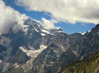
The Dufourspitze is the highest peak of Monte Rosa, an ice-covered mountain massif in the Alps. Dufourspitze is the highest mountain of both Switzerland and the Pennine Alps and is also the second-highest mountain of the Alps and Western Europe, after Mont Blanc. It is located between Switzerland and Italy. The peak itself is located wholly in Switzerland.
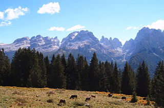
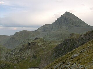
The Brenta Group or Brenta Dolomites is a mountain range, and a subrange of the Rhaetian Alps in the Southern Limestone Alps mountain group. They are located in the Province of Trentino, in northeastern Italy. It is the only dolomitic group west of the Adige River. Therefore, geographically, they have not always been considered a part of the Dolomites mountain ranges. Geologically, however, they definitely are - and therefore sometimes called the "Western Dolomites". As part of the Dolomites, the Brenta Group has been officially recognized as UNESCO World Heritage Site under the World Heritage Convention.

A via ferrata is a protected climbing route found in the Alps and certain other Alpine locations. The protection includes steel fixtures such as cables and railings to arrest the effect of any fall, which the climber can either hold onto or clip into using climbing protection. Some via ferrata can also include steel fixtures that provide aid in overcoming the obstacles encountered, including steel ladders and steel steps.

Alta Via 1 is a 125-kilometre-long high-level public footpath which runs through the eastern Dolomites in Italy. It is also known as the Dolomite High Route 1. It passes through some of the finest scenery in the Dolomites. The path runs south from Pragser Wildsee, near Toblach, to Belluno. Prags can be accessed by bus, and Belluno has both train and bus services.

Gavia Pass (el. 2621 m.) is a high mountain pass in the Italian Alps. It is the tenth highest paved road in the Alps.
The Jägerhorn is a mountain of the Pennine Alps, located on the border between Switzerland and Italy. It is the northernmost summit of Monte Rosa, at a height of 3,970 metres above sea level, and overlooks the village of Macugnaga on its east side, 2,600 metres below. On its west side it overlooks the Gorner Glacier.

The Grivola is a mountain in the Graian Alps in Italy. It lies between the Valsavarenche and the Cogne Valley.

Boč, also called the Triglav of Slovene Styria, is a 978-metre-high (3,209 ft) mountain in eastern Slovenia. It belongs to the municipalities of Poljčane and Rogaška Slatina. Boč, which is among the southernmost extensions of the Karawanks mountain range, is the central mountain of the Boč–Donatus Mountain Landscape Park. It has two peaks, which are five minutes apart. At one peak, there are transmitters. In the other, a 20-metre (66 ft) lookout tower has stood since 1962. The mountain, covered with forest and protected as a natural park, has a number of trails that vary in difficulty level and is also home to the protected Greater Pasque Flower. The plant grows in the vicinity of St. Nicholas Church and the Hut Under Mt. Boč on the southern slope of Boč. A sculpture of the Greater Pasque Flower, work of the sculptor Franc Tobias from Razvanje, has been put on display on a small rise near its growing place.

The Biellese Alps are a sub-range of the Pennine Alps located between Piemonte and Aosta Valley (Italy).
The Wasenhorn is a mountain of the Lepontine Alps, located on the border between Switzerland and Italy. It lies halfway between Brig and Varzo, just north of Monte Leone, in the Simplon Pass area. Politically the Wasenhorn is split between the municipalities of Ried-Brig and Varzo.

Speikboden is a massif in the Central Eastern Alps located between the three valleys Weißenbach, Mühlwald and Ahrntal. Running in a south-easterly direction, it forms the eastern part of an outlier of the western Zillertal Alps. Its highest point, likewise named Speikboden, is 2,517 m. Further well-known peaks in this massif include Seewassernock (2,516 m), Große Nock (2,400 m), Kleine Nock (2,227 m) and Gornerberg (2,475 m).

Ernesto Luigi Lomasti was an Italian mountaineer and alpino skier. He is regarded as one of the Italian pioneers of climbing as a sport. He died during training in the Valle d'Aosta, Arnad, in the local alpini training place called "la groviera", he fell apparently being struck by lightning. He is also remembered for techniques on the Machaby pillar, in Arnaud, in May 1979. The pillar today is named Lomasti pillar.

The Jôf di Montasio is a mountain located in the Province of Udine, in the Friuli-Venezia Giulia region of northeastern Italy.

Corna Trentapassi is a mountain of the Brescia Pre-Alps in Italy. It is 1248m high, located on the eastern shore of Lake Iseo. It marks the beginning of Val Camonica. It is made up of limestone rocks which give it a harsh and steep aspect. Vegetation cover is scarce, especially on the barren southern slope.
Monte Albergian is a 3,041 m a.s.l. mountain of the Cottian Alps, located in Italy. A battalion of 3rd Alpini Regiment, which during World War I earned a Silver Medal of Military Valor, was named after Monte Albergian.
The Viso Mozzo is a 3,019 metres high mountain on the Italian side of the Cottian Alps.

The Monte Capezzone is a mountain in the Pennine Alps of north-western Italy; with an elevation of 2,421 m (7,943 ft) is the highest peak of the Strona Valley.

Monte Alben, with a height of 2019 m above sea level, is a mountain in the Bergamasque Prealps, located along the ridge separating the Brembana Valley from the Seriana Valley, in the province of Bergamo.

Mount Bue is a mountain in the Ligurian Apennines that is part of the Maggiorasca mountain group, located on the watershed between the Aveto, Ceno and Nure valleys, on the border between the metropolitan city of Genoa and the provinces of Parma and Piacenza, between the municipalities of Santo Stefano d'Aveto, Bedonia and Ferriere. It is the second highest peak in the Ligurian Apennines, after nearby Mount Maggiorasca and the highest peak in the province of Piacenza.

