Schlachte (Bremen)

Last updated
Schlachte Embankment, Bremen BremenSchlachte-03.jpg
Schlachte Embankment, Bremen

The Schlachte is a promenade along the east bank of the River Weser in the old town of Bremen in the north of Germany. Once one of the city's harbours, it is now popular for its restaurants, beer gardens and river boats. [1]

Contents

Etymology

Schlachte is a Low German word for a river bank reinforced with wooden piles driven in by the action of hammering (cf. German eingeschlagenen). The word slait was used as early as 1250 to refer to the river bank in Bremen. [2]

History

Woodcut by Hans Weigel (c. 1550) Bremen in the 16th century - Hans Weigel - 1564-crop.jpg
Woodcut by Hans Weigel (c. 1550)

In 1247, following authorisation from Archbishop Gerhard II, the area between St Martini's Church and Zweite Schlachtpforte (a street meaning "second quayside gate") was settled by local citizens and traders. In 1250, those privileged to operate water mills were required to maintain the wooden piles used to reinforce the river bank. [3] In the 13th century, both the Schlachte and the Balge were used as harbours for wood (used as firewood) and limestone although the banks of the Balge soon became Bremen's main port. [4] Both harbours were used until the 16th century, the Balge for sea-going ships and the Schlachte for flat-bottomed vessels and river barges. [5] As a result of the silting of the Weser in the early 17th century, the Schlachte became Bremen's main harbour until the beginning of the 19th century. [6]

The appearance of the Schlachte on the woodcut (pictured) from c. 1550 clearly shows a quayside with timber reinforcement although a little later a stone structure was substituted. In 1557, the Schlachte officially became part of the city of Bremen. From 1600 to 1830, there was little change in the appearance of the Schlachte and the rare changes harbour equipment were to the great cranes. It stretched 450 m (1,480 ft) from St Martini Church to the Kornhaus. On the town side, it was bordered by a row of half-timbered houses. [7]

An increase in freight in the first half of the 19th century brought about a modest extension to the Schlachte but the arrival of the railway in 1860 brought major changes to Bremen's harbours, especially after Bremerhaven was connected to the rail network in 1862. Thereafter, the Schlachte played no further part as a harbour for the city. [8]

20th-century development

As the offices and storerooms in the buildings along the Schachte had not been used for decades, at the end of the 20th century it was decided to undertake a comprehensive transformation of the area, given its attractive location on the riverside. Following the introduction of a pedestrian zone in 1985, between 1993 and 2000 many of the buildings were rebuilt under the "Stadt am Fluss" (Town on the River) chapter of Expo 2000. [9]

The cog Roland von Bremen Bremen Hansekogge RolandvonBremen.JPG
The cog Roland von Bremen

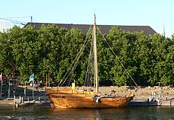
The lower level of the Schlachte was extended upstream and downstream as a modern promenade connected to paths leading into the old town. As a result, it became possible to walk some two kilometres along the riverside. Thereafter, the upstream section from Erste Schlachtpforte (first quayside gate) to the Bürgermeister Smidt Bridge was transformed into a promenade with a historic flair. The ground floors of former warehouses were converted into restaurants, bars and pubs with extensive open-air seating. Modern berths with moorings for several ships were introduced, accommodating the Friedrich and the Roland von Bremen, copied from the remains of a 14th-century cog discovered in 1962. [10]

In 1996, a pedestrian footbridge was built connecting the Schlachte to the Teerhof peninsula in the middle of the River Weser. [11] The promenade was further extended downstream from the Bürgermeister Smidt Bridge to the Diepenau corner in 2008. [12]

The Schlachte today

A number of ships moored along the Schlachte offer river tours up and down the River Weser. There are also landing stages available for those visiting the city in their pleasure craft. The restaurants on the promenade or on board some of the ships on the quayside offer both local dishes and specialities from more exotic regions. Accommodation is available at the youth hostel and on hotel ships. There are also a number of special events in the summer months including a regatta, flea markets and a barbecue festival. [2]

Related Research Articles

Weser River in Germany

The Weser is a river in Northwestern Germany. Formed at Hannoversch Münden by the confluence of the rivers Fulda and Werra, it flows through Lower Saxony, then reaching the Hanseatic city of Bremen, before emptying 50 km (31 mi) further north at Bremerhaven into the North Sea. On the opposite (west) bank is the town of Nordenham at the foot of the Butjadingen Peninsula; thus, the mouth of the river is in Lower Saxony. The Weser has an overall length of 452 km (281 mi). Together with its Werra tributary, which originates in Thuringia, its length is 744 km (462 mi).

Aktien-Gesellschaft „Weser" was one of the major German shipbuilding companies, located at the Weser River in Bremen. Founded in 1872 it was finally closed in 1983. Altogether, A.G. „Weser" built about 1,400 ships of different types, including many warships. A.G. „Weser" was the leading company in the Deutsche Schiff- und Maschinenbau AG, a cooperation of eight German shipbuilding companies between 1926 and 1945.

Bremen (state) State in Germany

Bremen, officially the Free Hanseatic City of Bremen, is the smallest and least populous of Germany's 16 states. It is informally called Land Bremen, although this is sometimes used in official contexts. The state consists of the city of Bremen as well as the small exclave of Bremerhaven in Northern Germany, surrounded by the larger state of Lower Saxony.

<i>Alexander von Humboldt</i> (ship) barque

Alexander von Humboldt is a German sailing ship originally built in 1906 by the German shipyard AG Weser at Bremen as the lightship Reserve Sonderburg. She was operated throughout the North and Baltic Seas until being retired in 1986. Subsequently, she was converted into a three masted barque by the German shipyard Motorwerke Bremerhaven and was re-launched in 1988 as Alexander von Humboldt. In 2011 the ship was taken off sail-training and sent to the Caribbean for the charter business, then she was converted to a botel her sailing days over for now and is currently stationed in Bremen, Germany

Bremen-Vegesack District in Free Hanseatic City of Bremen, Germany

Vegesack is a northern district of the city of Bremen.

Bremer Vulkan AG was a prominent German shipbuilding company located at the Weser river in Bremen-Vegesack. It was founded in 1893 and closed in 1997 because of financial problems and mismanagement.

Brake, Lower Saxony Place in Lower Saxony, Germany

Brake is the district seat of Wesermarsch district in northern Germany.

Bremen Place in Germany

The City Municipality of Bremen is the capital of the German federal state Free Hanseatic City of Bremen, a two-city-state consisting of the cities of Bremen and Bremerhaven. With around 570,000 inhabitants, the Hanseatic city is the 11th largest city of Germany as well as the second largest city in Northern Germany after Hamburg.

Seebeckwerft A.G. was a German shipbuilding company, located in Bremerhaven at the mouth of the river Weser. Founded in 1876 it became later one of the leading shipbuilding companies in the region.

Balge Place in Lower Saxony, Germany

Balge is a municipality in the district of Nienburg, in Lower Saxony, Germany, located on the Weser river. The community belongs to the Marklohe which consists of seven municipalities including Balge.

Schnoor street in Bremen

Schnoor is a neighbourhood in the medieval centre of the German city of Bremen, and the only part of it that has preserved a medieval character. The neighbourhood owes its name to old handicrafts associated with shipping. The alleys between the houses were often associated with occupations or objects: There was an area in which ropes and cables were produced and a neighboring area, where wire cables and anchor chains were manufactured.

Bremerhaven Place in Bremen, Germany

Bremerhaven is a city at the seaport of the Free Hanseatic City of Bremen, a state of the Federal Republic of Germany.

Elbe–Weser triangle

The region between the Elbe and Weser rivers forms the Elbe–Weser triangle, also rendered Elbe-Weser Triangle, in northern Germany. It is also colloquially referred to as the Nasses Dreieck or "wet triangle".

Carlsburg, Weser

Carlsburg was a 17th-century fortified town in Swedish Bremen-Verden at the confluence of the Weser and Geeste rivers, at the site of modern Bremerhaven, Germany. Planned to compete with Bremen, the settlement did not prosper.

Balge (river) geographical object

The Balge was a short branch of the Weser on its eastern side, running through what is now the centre of Bremen. As it served as a harbour in the early Middle Ages, it significantly contributed to Bremen's development as a port. The river gradually narrowed until in 1608, it was canalised. In 1838, it was completely filled with earth.

Teerhof

The Teerhof is a peninsula between the River Weser and the Kleine Weser, opposite the city centre of Bremen, Germany. It was first mentioned in 1624 as "Theerhof" when it was the northernmost part of an island. Today it consists mainly of residential buildings and the Weserburg modern art museum.

Schlachte Great Crane

The Schlachte Cranes were important to the port of Bremen as they enabled heavy loads to be moved off boats on the River Weser. The Schlachte became an important harbour for the city after silting prevented the use of the Balge as a harbour. Today, only the foundations of a 19th-century crane remain on the Weser waterfront.

Langenstraße (Bremen) street in Mitte, Germany

The Langenstraße is a historical street in the old town of Bremen in the north of Germany. First mentioned in 1234, it is one of Bremen's oldest streets and one of the most important for the city's merchants. It no doubt originated at the time when the first settlements grew up on the north bank of the Balge. It runs west from the Marktplatz parallel to the River Weser over Bürgermeister-Smidt-Straße to Geeren. Many of the street's historic buildings were seriously damaged during aerial bombings in the Second World War but were carefully reconstructed in the postwar period.

Suding & Soeken building, Bremen gabled house at No. 28 Langenstraße in Bremen, Germany

The Suding & Soeken building is a gabled house at No. 28 Langenstraße in Bremen, Germany. Referred to as a Kaufmannshaus or Kontorhaus, it is one of the city's few historic merchant houses to survive the war undamaged. It is noted for its projecting Renaissance bay window and its two-tiered Baroque stairway ascending from the hallway.

Ports of Bremen ports and harbours in Bremen and Bremerhaven, Germany

The Ports of Bremen, Bremen Ports or Bremish Ports, in German "Bremische Häfen" consist of the commercial ports in Bremen and Bremerhaven. They are managed by bremenports GmbH & Co. KG, a company of private status in public property.

References

  1. "Schlachte Embankment". bremen-tourism.de. Retrieved 5 January 2014.
  2. 1 2 "Weserpromenade Schlachte" (PDF). Schlachte Marketing und Service Verband. Retrieved 5 January 2014.
  3. "An Weser und Jade: 13. Jahrhunder" (in German). Klaus Dede. Retrieved 5 January 2014.
  4. Hill, Thomas (2004). Die Stadt und ihr Markt: Bremens Umlands- und Aussenbeziehungen im Mittelalter (12.-15. Jahrhundert). Franz Steiner Verlag. pp. 77–. ISBN   978-3-515-08068-2.
  5. Hill (2004), 265
  6. "Die Schlachte – Bremens Uferhafen" (in German). Schlachte.de. Retrieved 7 January 2014.
  7. Lydia Niehoff, „Zum goldenen Anker“ - Bier schenken in den Schenken an der Schlachte, in: Christian Marzahn/Astrid Schneider (Hrsg.), Genuß und Mäßigkeit, Beiträge zur Sozialgeschichte Bremens, Heft 17, Edition Temmen, Bremen 1995, ISBN   3-86108-228-4, pp. 29-52.(in German)
  8. Hoffmann, Hans-Christoph (1986). Bremen: Bremerhaven und das nördliche Niedersachsen : Kultur, Geschichte, Landschaft zwischen Unterweser und Elbe. DuMont. ISBN   978-3-7701-1754-3.
  9. "Schlachte Neugestaltung" (in German). architektführer bremen. Retrieved 6 January 2014.
  10. "Maritime Bremen". bremen-tourism.de. Retrieved 6 January 2014.
  11. "Teerhofbrücke" (in German). Stadt Bremen: Neue Architecture in Bremen und Bremerhaven. Retrieved 7 January 2014.
  12. "Umgestaltung der oberen Schlachte" (in German). EFRE in Bremen. Retrieved 7 January 2014.

Literature

Coordinates: 53°4′34″N8°48′08″E / 53.07611°N 8.80222°E / 53.07611; 8.80222