Schluchsee

Last updated
Schluchsee
Schluchsee bei Aha 02.jpg
Relief Map of Germany.svg
Red pog.svg
Location of Schluchsee in Germany
Country Germany
Location Breisgau-Hochschwarzwald
Coordinates 47°49′17″N08°09′10″E / 47.82139°N 8.15278°E / 47.82139; 8.15278
Construction began1929
Opening date1932
Dam and spillways
Height63.5 m
Length250 m
Width (crest)3.7 m
Dam volume124,000 m3
Spillway capacity139.8 m3/s
Reservoir
Total capacity114.3 MCM
Catchment area 72.78 km2
Surface area5.14 km2

The Schluchsee is a reservoir lake in the district of Breisgau-Hochschwarzwald, southeast of the Titisee in the Black Forest near Freiburg im Breisgau, Germany.

Contents

Name

In the Alemannic dialects of the region the name of the lake is the Schluechs[ʃluˑəχs] or Schlues[ʃluˑəs]. [1] Historical sources also spell it with a diphthong: 983 lacus Sluochse, 1095 Schluochsee, 1125 predium Sluocse, 1312 der sê ze Sluoze. [1] Thus it cannot be claimed that the name, as is often asserted, [2] from the Middle High German slûch ="pipe, tube" (Alemannic Schluuch), because in this case in the present dialect and the historical sources no diphthong was available. Albert Krieger links the name to the Middle High German sluocht "ravine". [1] [3] But this meaning is also not accurate.

Location

Bahnbrucke Schluchsee.jpg

The Schluchsee, with its height of 930 metres (3,050 ft) above sea level, is the highest reservoir in Germany and also the largest lake in the Black Forest. [4] [5] By contrast, the Hornberg Basin (Hornbergbecken) is 1,048 metres above sea level, but is the upper basin of a pumped storage hydropower station, rather than a reservoir.

The water of the reservoir is relatively cool even in summer because of its high elevation.

The best-known settlements around the Schluchsee are on its northern shores and include the eponymous town of Schluchsee and the hamlets of Seebrugg by the dam itself and Aha. The Three Lakes Railway, an extension of the Höllentalbahn, runs from Titisee station along the northern shore to the terminus at Seebrugg.

History

The original lake, now drowned, with its large raised bog, the Feldmoos Schluchsee-Ursee.jpg
The original lake, now drowned, with its large raised bog, the Feldmoos
Der zugefrorene Schluchsee 3.jpg

The surface of the original, undammed Schluchsee, a glacier lake, was around 30 metres lower than that of today's reservoir. Despite the dam, the Schluchsee appears natural. The lake is 7.3 km long by 1.4 km across. Its 63.5 m high dam was built between 1929 and 1932, impounding the river Schwarza. In order to construct this gravity dam, the natural lake had first to be deepened by 13 metres. That was achieved in 1930 by a blasting out a tunnel in the rock. After that the intake structure of the dam could be built. Today the lake has a maximum depth of 61 m. [4]

The Schluchsee is part of the Schluchsee hydropower station complex run by the Schluchseewerk which has a number of reservoirs of different heights linked by pumping stations. This complex stretches from Häusern to Waldshut. The Schluchsee is therefore the upper basin of the Häusern pump storage hydropower station. The average power generated by the Häusern power station is 100 Megawatts. [6]

In 1982 the Schluchsee became known Germany-wide as the Schlucksee ("Swig Lake") because the German football team 1982 chose the area as their training camp and some players, permitted by the team manager, Jupp Derwall, made full use of it. Excessive alcohol consumption, card games and other escapades showed the subsequent world runners-up in a bad light. [7]

In 1983 almost all the water in the reservoir was drawn down for inspection purposes, rendering the normal swimming, fishing and sailing activities impossible. This rare occurrence still drew many visitors, however, because for the first time the drowned settlements were visible again.

In recent times there have been several conflicts between the Schluchseewerk and the municipality of Schluchsee over the water level of the lake in summer. Whilst the Schluchseewerk is interested in the optimal, economic use of the water and therefore a considerable reduction in the level of the lake, the town is concerned about losing tourists if the lake falls too low for long periods during the summer and exposes a rather unsightly shoreline.

Tourism

Tourist use of the Schluchsee Schluchsee-Nutzung.JPG
Tourist use of the Schluchsee

Due to its height above sea level, the water of the Schluchsee is relatively cool even in summer. Nevertheless, the lake is popular particularly with swimmers and sailors. Unlike the Titisee, almost all of the Schluchsee's shoreline is easily accessible. As a result, the Schluchsee is very busy in summer and is a popular local resort - even just across the Swiss border. Skinny dipping on the forested side of the lake occasionally causes offence however.

In Seebrugg's station building there is a diving base for diving in the Schluchsee. [8]

The Schluchsee is surrounded by a plethora of hiking trails and the entire lake can be circumnavigated on foot along an 18-kilometre-long path which is largely flat and suitable for prams. From May to October, the walks may be combined with boat trips on the MS Schluchsee.

In 2001, a roughly 30.45-metre-high [9] viewing tower, the Riesenbühl Tower, was built at Riesenbühl (1,097 m, north of the village of Schluchsee) from which there are views over most of the lake.

Fishing

You need a valid German fishing licence in order to be allowed to fish at Schluchsee. Only then you will receive a fishing permit. There are special regulations for holidaymakers. Fishing licences and further information can be obtained from the Citizens' Office in Schluchsee Town Hall. [10]

Walking

The Schluchsee is surrounded by numerous walking trails in the local area. The entire length of the shoreline, about 18 km long, is walkable, mostly level and suitable for prams. From May to October the walks may be combined with boat trips on the pleasure cruiser St. Nikolaus.

Schluchsee Bildstein.jpg
View from Bildstein
Panorama zugefrorener Schluchsee.jpg
A frozen Schluchsee seen from the B 500 federal road

Related Research Articles

<span class="mw-page-title-main">Black Forest</span> Mountain range in Germany

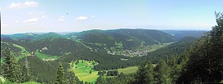
The Black Forest is a large forested mountain range in the state of Baden-Württemberg in southwest Germany, bounded by the Rhine Valley to the west and south and close to the borders with France and Switzerland. It is the source of the Danube and Neckar rivers.

Breisgau-Hochschwarzwald is a Landkreis (district) in the southwest of Baden-Württemberg, Germany. Fifty towns and municipalities with 133 settlements lie within the district. The district itself belongs to the region of Freiburg with the region of Southern Upper Rhine.

<span class="mw-page-title-main">Höllentalbahn (Black Forest)</span>

The Höllentalbahn is a railway line that partially runs through the Höllental valley in the Black Forest of Germany. The line connects Freiburg im Breisgau with Donaueschingen, a distance of 74.7 km (46.4 mi).

<span class="mw-page-title-main">Sankt Märgen</span> Municipality in Baden-Württemberg, Germany

Sankt Märgen is a German municipality in the middle of the Black Forest, which belongs to the district of Breisgau-Hochschwarzwald. The Kurort is located around 25 km east of Freiburg im Breisgau.

<span class="mw-page-title-main">Titisee-Neustadt</span> Town in Baden-Württemberg, Germany

Titisee-Neustadt is a municipality in the district of Breisgau-Hochschwarzwald in Baden-Württemberg in southern Germany. It is made up of the six communities of Neustadt, Langenordnach, Rudenberg, Titisee, Schwärzenbach and Waldau.

<span class="mw-page-title-main">Titisee</span>

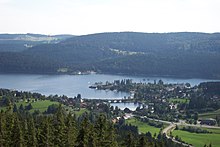
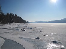
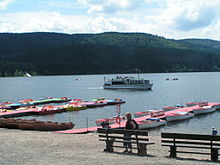
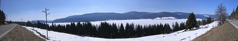
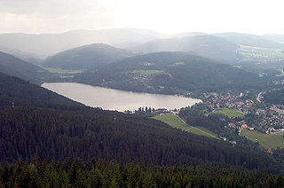
The Titisee is a lake in the southern Black Forest in Baden-Württemberg. It covers an area of 1.3 km2 and is an average of 20 m (66 ft) deep. It owes its formation to the Feldberg glacier, the moraines of which were formed in the Pleistocene epoch and nowadays form the shores of the lake. The lake's outflow, at 840 m (2,760 ft) above sea level, is the River Gutach, which merges with the Haslach stream below Kappel to form the Wutach. The waters of the Titisee thus drain eventually into the Upper Rhine between Tiengen and Waldshut. On the north shore lies the spa town of the same name, today a part of the municipality of Titisee-Neustadt.

<span class="mw-page-title-main">Feldberg, Baden-Württemberg</span> Municipality in Baden-Württemberg, Germany

Feldberg is a municipality in the district of Breisgau-Hochschwarzwald in Baden-Württemberg in southern Germany. It is located near the Feldberg, the highest summit in Baden-Württemberg. It comprises the settlements of Altglashütten, Neuglashütten, Falkau, Bärental, and Feldberg. At an elevation of 1,277 m, the last is considered the highest village in Germany.

<span class="mw-page-title-main">Buchenbach</span> Municipality in Baden-Württemberg, Germany

Buchenbach is a municipality in the south west of the Black Forest in Germany. It is located in the district of Breisgau-Hochschwarzwald in Baden-Württemberg. It is made up of four communities, the main town of Buchenbach and the villages of Falkensteig, Unteribental and Wagensteig. The current municipality was formed by the merger of the former entities of Buchenbach and Falkensteig on 1 December 1971, with Wagensteig being joined to them on 1 August 1973 and Unteribental on 1 January 1975.

<span class="mw-page-title-main">Lenzkirch</span> Municipality in Baden-Württemberg, Germany

Lenzkirch is a municipality in the Black Forest. It lies in the district of Breisgau-Hochschwarzwald in Baden-Württemberg in Germany.

<span class="mw-page-title-main">Wutach (river)</span> River in Germany

The Wutach is a river, 91 kilometres long, in the southeastern part of the Black Forest in the German state of Baden-Württemberg. It is a right-hand tributary of the Rhine. In its lower reaches it flows for about 6 kilometres along the border with the canton of Schaffhausen, Switzerland.

<span class="mw-page-title-main">Windgfällweiher</span>

The Windgfällweiher is a reservoir between the Titisee and the Schluchsee in the south of Baden-Württemberg, Germany. It is located within the High Black Forest and lies in a hollow formed by ice age glaciation between the villages of Altglashütten, Falkau and Aha on the territory of the municipality of Lenzkirch.

<span class="mw-page-title-main">Three Lakes Railway</span>

The Three Lakes Railway is a 19.2 km (11.9 mi) long line in the German state of Baden-Württemberg. The line is electrified to the standard 15 kV, 16⅔ Hz system commonly used throughout the German railway network.

<span class="mw-page-title-main">Alb (High Rhine)</span> River in Germany

The Alb is a river in the southern Black Forest. It arises from two headwaters, the Menzenschwander Alb and Bernauer Alb, and flows in a southerly direction. It ends after 43.6 kilometres (27.1 mi) at a confluence with the High Rhine at Albbruck.

<span class="mw-page-title-main">IG 3-Seenbahn</span>

The Interessengemeinschaft 3-Seenbahn e.V. is a German heritage railway located in Schluchsee-Seebrugg in Black Forest. It was founded on 13 January 2008 to prevent the demolition of the former freight yard in Seebrugg. At certain dates all over the year the volunteers organize and operate vintage train rides on the Three Lakes Railway and on the Höllentalbahn

<span class="mw-page-title-main">Falkenstein Castle (Höllental)</span> Ruined hill castle

Falkenstein Castle is a ruined hill castle near Freiburg im Breisgau on the territory of the present-day municipality Breitnau in the county of Breisgau-Hochschwarzwald in the German state of Baden-Württemberg. The castle site lies in a triangle formed by the entrance of the Höllental valley – the Lower Höllental and the Engenbach valley, not far from the Buchenbach village of Falkensteig, 617.6 m above sea level (NN) on a rocky crag that is very difficult to get to today. Of the castle itself only a few wall remains are left. It is one of the less well preserved ruins in the Breisgau.

<span class="mw-page-title-main">Weißtannenhöhe</span>

The Weißtannenhöhe is a mountain, 1,190 or 1,192 metres high, in the Black Forest in Germany and the highest point in the municipality of Breitnau.

<span class="mw-page-title-main">Neustadt (Schwarzw) station</span>

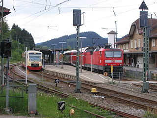
Neustadt (Schwarzw) station is one of two stations in Titisee-Neustadt in the German state of Baden-Württemberg. The other is Titisee. It is located in Neustadt at 805 metres above sea level on the Höllentalbahn, which links Freiburg with Donaueschingen. The station has three platform tracks and is classified by Deutsche Bahn (DB) as a category 5 station. Established in 1887, the entrance building is now heritage-listed and houses among other things a DB agency with ticket sales.

<span class="mw-page-title-main">Alb Basin</span> Dam in Waldshut in Baden-Württemberg

The Alb Reservoir, or Alb Basin (Albbecken) is a storage reservoir in the valley of the River Alb near St. Blasien in the Southern Black Forest in south Germany. It is part of the pumped storage network of the Schluchseewerk based at Laufenburg and lies between the lake of Schluchsee and the Rhine near Waldshut. The barrier is a 28-metre-high gravity dam.

Menzenschwand is a climatic health spa in the Black Forest in Germany. The village lies within the borough of St. Blasien in the state of Baden-Württemberg.

<span class="mw-page-title-main">Schluchseewerk</span>

The Schluchseewerk AG is the operator of five pumped storage hydroelectric power stations in the Southern Black Forest in the German state of Baden-Württemberg. Its head office is in Laufenburg (Baden).

References

  1. 1 2 3 Badisches Wörterbuch, Vol. IV, p. 622 f.
  2. see e.g. Entwicklungsplanung für Schluchsee und den Südschwarzwald. Projektbericht. Archived 2016-09-27 at the Wayback Machine Hochschule für Technik, Fakultät Architektur und Gestaltung, Masterstudiengang Stadtplanung. Ed. by Philipp Englert and Dennis Lakemann. Stuttgart, January 2006, p. 9.
  3. Topographisches Wörterbuch des Großherzogtums Baden. Bearbeitet von Albert Krieger. 2. Auflage, Heidelberg, 1904–1905; Vol. 2, p. 866.
  4. 1 2 Seen und Weiher im südlichen Hochschwarzwald und Breisgau, Freiburg-Schwarzwald.de at www.freiburg-schwarzwald.de. Retrieved on 19 Oct 2009.
  5. Schluchsee als Stausee at www.alemannische-seiten.de, Südbaden. Retrieved on 19 Oct 2009.
  6. Das Kraftwerk Häusern, Schluchseewerk, at www.schluchseewerk.de. Retrieved on 19 Oct 2009.
  7. Exzesse am Schlucksee, Eike Immel (Protokoll:Andreas Bock), 11Freunde. Retrieved on 19 Oct 2009.
  8. "Tauchgebiet Schluchsee | Tauchbasis Schluchsee" (in German). Archived from the original on 2015-01-18. Retrieved 2014-03-22.
  9. Der Riesenbuehlturm at riesenbuehlturm.de.
  10. "Gemeinde Schluchsee – Angeln am Schluchsee".