Hildburghausen is a district in Thuringia, Germany. It is bounded by the district of Schmalkalden-Meiningen, the city of Suhl, the districts of Ilm-Kreis, Saalfeld-Rudolstadt and Sonneberg, and the state of Bavaria. Located roughly halfway between the mountain chains of the Rhön and the Thuringian Forest, the district is densely forested and covered by hilly countryside. Its territory is similar to that of the former Ernestine duchy, Saxe-Hildburghausen.
Ilm-Kreis is a district in Thuringia, Germany. It is bounded by the city of Erfurt, the districts of Weimarer Land, Saalfeld-Rudolstadt and Hildburghausen, the city of Suhl, and the districts of Schmalkalden-Meiningen and Gotha. It is named after the river Ilm, flowing through the district.
Saalfeld-Rudolstadt is a Kreis (district) in the south of Thuringia, Germany. Neighboring districts are the districts Weimarer Land, Saale-Holzland, Saale-Orla, the district Kronach in Bavaria, and the districts Sonneberg, Hildburghausen and Ilm-Kreis.
Weimarer Land is a Landkreis (district) in the east of Thuringia, Germany. Neighboring districts are the district Burgenlandkreis in Saxony-Anhalt, the district Saale-Holzland and the district-free city Jena, the district Saalfeld-Rudolstadt, Ilm-Kreis, and the district-free city Erfurt. The district-free city Weimar is completely enclosed by the district.

Bad Sulza is a town in the Weimarer Land district, in Thuringia, Germany. It is situated on the river Ilm, 15 km southwest of Naumburg, and 18 km north of Jena.

Großbreitenbach is a town in the Ilm-Kreis district, in Thuringia, Germany. It is situated 13 km southeast of Ilmenau. It has about 8000 inhabitants. Major industries are glass manufacturing and tourism. The former municipalities Altenfeld, Böhlen, Friedersdorf, Gillersdorf, Herschdorf, Neustadt am Rennsteig and Wildenspring were merged into Großbreitenbach in January 2019.
Kranichfeld is a town in the Weimarer Land district, in Thuringia. It is situated on the river Ilm, 18 km southeast of Erfurt, and 16 km southwest of Weimar.
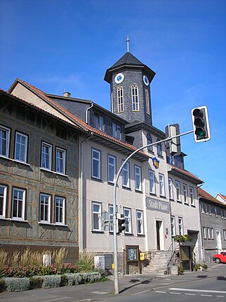
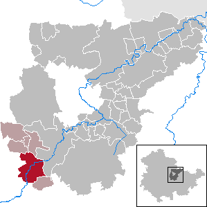
Plaue is a town in the Ilm-Kreis district, in Thuringia, Germany. It is situated on the river Gera, 11 km north of Ilmenau, and 8 km southwest of Arnstadt. The former municipality Neusiß was merged into Plaue in January 2019. Plaue station lies on the Neudietendorf–Ritschenhausen railway.

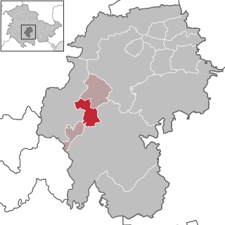
Stadtilm is a town in the Ilm-Kreis district, in Thuringia, Germany. It is situated on the river Ilm, 15 km northeast of Ilmenau, and 11 km southeast of Arnstadt. In July 2018 the former municipality of Ilmtal was merged into Stadtilm.

Witzleben is a municipality in the district Ilm-Kreis in Thuringia, Germany.

Ilmtal-Weinstraße is a municipality in the district Weimarer Land, in Thuringia, Germany. It was named after the river Ilm, that flows through the municipality. It was formed on 31 December 2013 by the merger of the former municipalities Liebstedt, Mattstedt, Niederreißen, Niederroßla, Nirmsdorf, Oberreißen, Oßmannstedt, Pfiffelbach and Willerstedt. Before, these municipalities had cooperated in the Verwaltungsgemeinschaft Ilmtal-Weinstraße, which was disbanded. The seat of the municipality and of the former Verwaltungsgemeinschaft is in Pfiffelbach. The former municipalities Kromsdorf, Rohrbach and Leutenthal were merged into Ilmtal-Weinstraße in January 2019.

Dornheim is a municipality in the district Ilm-Kreis, in Thuringia, Germany.

Elxleben is a municipality in the district Ilm-Kreis, in Thuringia, Germany.
Martinroda is a municipality in the district Ilm-Kreis, in Thuringia, Germany. The former municipality Angelroda was merged into Martinroda in December 2019.

Bösleben-Wüllersleben is a municipality in the district Ilm-Kreis, in Thuringia, Germany.

Elgersburg is a municipality situated in the district of Ilm-Kreis, Thuringia, Germany.

Elleben is a municipality in the district Ilm-Kreis, in Thuringia, Germany. Elleben has two named communities, Riechheim and Gügleben.
Osthausen-Wülfershausen is a municipality in the district Ilm-Kreis, in Thuringia, Germany.

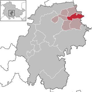
Amt Wachsenburg is a municipality in the district Ilm-Kreis, in Thuringia, Germany. The municipality is named after the Wachsenburg Castle which is located in its center. It was formed on 31 December 2012 from the former municipalities Wachsenburggemeinde and Ichtershausen. The former municipality Kirchheim was merged into Amt Wachsenburg in January 2019, and Rockhausen in December 2019. It consists of the villages Bechstedt-Wagd, Bittstädt, Eischleben, Haarhausen, Holzhausen, Ichtershausen, Kirchheim, Rehestädt, Rockhausen, Röhrensee, Sülzenbrücken, Thörey and Werningsleben.
Weimar I – Weimarer Land II is an electoral constituency represented in the Landtag of Thuringia. It elects one member via first-past-the-post voting. Under the current constituency numbering system, it is designated as constituency 31. It covers the eastern part of Weimarer Land and small parts of the city of Weimar.


