Weimar is a city in the German state of Thuringia, in Central Germany between Erfurt to the west and Jena to the east, 80 km (50 mi) southwest of Leipzig, 170 km (106 mi) north of Nuremberg and 170 km (106 mi) west of Dresden. Together with the neighbouring cities of Erfurt and Jena, it forms the central metropolitan area of Thuringia, with approximately 500,000 inhabitants. The city itself has a population of 65,000. Weimar is well known because of its cultural heritage and importance in German history.
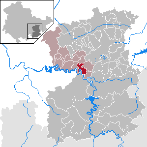
Saale-Holzland is a Kreis (district) in the east of Thuringia, Germany. Neighboring districts are the district Burgenlandkreis in Saxony-Anhalt, the district-free city Gera, the districts Greiz, Saale-Orla, Saalfeld-Rudolstadt, Weimarer Land and the district-free city Jena.

Apolda is a town in central Thuringia, Germany, the capital of the Weimarer Land district. It is situated in the center of the triangle Weimar–Jena–Naumburg near the river Ilm, c. 15 kilometres east by north from Weimar. Apolda station lies on the Halle–Bebra railway, which is part of the main line from Berlin to Frankfurt.

Rudolstadt is a town in the German federal state Thuringia, within the Thuringian Forest, to the southwest, and to Jena and Weimar to the north.

Bad Lobenstein is a spa town in the Saale-Orla-Kreis district, in Thuringia, Germany with a population of about 6,000 inhabitants. Until 2005, the town was named Lobenstein.
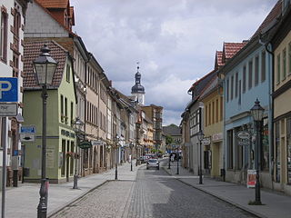
Eisenberg is a town in Thuringia, Germany. It is the capital of the district Saale-Holzland.

Blankenhain is a town in the Weimarer Land district, in Thuringia, Germany. It is 14 km south of Weimar.

Bürgel is a town in the Saale-Holzland district, in Thuringia, Germany. It is situated 12 km east of Jena. It contains the Benedictine monastery of Bürgel Abbey.

Neustadt an der Orla is a town in Saale-Orla-Kreis district, in Thuringia. It is situated at the small river Orla, 17 km north of Schleiz, and 25 km southeast of Jena. The former municipality Stanau was merged into Neustadt an der Orla in January 2019, and Linda bei Neustadt an der Orla, Knau and Dreba in December 2019.

Orlamünde is a small town in the Saale-Holzland district, in Thuringia, Germany. It is part of the Verwaltungsgemeinschaft Südliches Saaletal.
Ziegenrück is a town in the Saale-Orla-Kreis district, in southern Thuringia, Germany. It is situated on the river Saale, 22 km east of Saalfeld, and 35 km south of Jena.

Alkersleben is a municipality in the Ilm-Kreis district in Thuringia, Germany. The municipality is a member of the collective municipality Riechheimer Berg.

Kaulsdorf is a municipality in the district Saalfeld-Rudolstadt, in Thuringia, Germany.

Jena-Göschwitz station is a railway station in city of Jena in the German state of Thuringia. It is located 152.21 metres above sea level, 32.22 km from Großheringen on the Saal Railway and 27.50 from Weimar station on the Weimar–Gera railway. It opened on 1 July 1876 and is classified by Deutsche Bahn as a category 4 station.

Friedensburg Castle is an early 16th-century castle overlooking the valley of the Sormitz at Leutenberg in southeast Thuringia, Germany. It was formerly the residence of the Counts of Schwarzburg-Leutenberg and today is a dermatological medical facility.

Schloss Weimar is a Schloss (palace) in Weimar, Thuringia, Germany. It is now called Stadtschloss to distinguish it from other palaces in and around Weimar. It was the residence of the dukes of Saxe-Weimar and Eisenach, and has also been called Residenzschloss. Names in English include Palace at Weimar, Grand Ducal Palace, City Palace and City Castle. The building is located at the north end of the town's park along the Ilm river, Park an der Ilm. It forms part of the World Heritage Site "Classical Weimar", along with other sites associated with Weimar's importance as a cultural hub during the late 18th and 19th centuries.
The Imperial Castle of Kyffhausen is a medieval castle ruin, situated in the Kyffhäuser hills in the German state of Thuringia, close to its border with Saxony-Anhalt. Probably founded about 1000, it superseded the nearby imperial palace (Kaiserpfalz) of Tilleda under the rule of the Hohenstaufen emperors during the 12th and 13th centuries. Together with the Kyffhäuser Monument, erected on the castle grounds between 1890 and 1896, it is today a popular tourist destination. The castle is variously known in English as Kyffhausen Castle, Kyffhauser Castle, Kyffhäuser Castle, and Kyffhaueser Castle.
Schkölen Castle is a partially preserved water castle stand at a height of 210 metres above sea level (NN) in the centre of the town of Schkölen in the county of Saale-Holzland-Kreis in the German state of Thuringia. Until 1977 the ruins of the water castle lay almost forgotten and overgrown with briars in the middle of the little town.

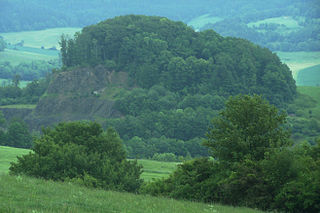
Bocksberg is a levelled, medieval hilltop castle on the top of the cone-shaped hill of Bocksberg in the Rhön Mountains near Geisa and Schleid.
Fischberg Castle was a high medieval fortification in the Felda valley that was sited on an exposed hill above the villages of Klings, Fischbach and Diedorf. Its ruins currently stand in the county of Wartburgkreis (Thuringia) - in the Anterior Rhön, part of a mountain region in central Germany.