
Tilburg is a city and municipality in the Netherlands, in the southern province of North Brabant. With a population of 222,601, it is the second-largest municipality in North Brabant and seventh-largest in the Netherlands.
Eersel is a municipality and a town in southern Netherlands in the province of North Brabant. Eersel is situated in the Campine (Kempen) area.

Veldhoven is a municipality and town on the Gender in the southern Netherlands, just southwest of Eindhoven.

Kortenberg is a Belgian municipality located in the province of Flemish Brabant, about halfway between the cities of Brussels and Leuven. The municipality comprises the subdivisions or deelgemeenten of Erps-Kwerps, Everberg, Kortenberg proper and Meerbeek. On 1 January 2013 Kortenberg had a total population of 19,393. The total area is 34.52 km² which gives a population density of about 562 inhabitants per km². In the southern part of Everberg there is also a hamlet called Vrebos, while between Erps-Kwerps and Meerbeek there is another hamlet called Schoonaarde, which can be found in the proximity of the train station of Erps-Kwerps.

Baarle is a village whose territory is divided into a patchwork of Belgian and Dutch territories. The Belgian parts of the village are called Baarle-Hertog and the Dutch elements are called Baarle-Nassau. The Belgian part includes 16 exclaves within Dutch territory. The exclaves, in turn, surround seven Dutch areas. Belgian territory also surrounds an eighth Dutch area near Ginhoven. In 1995, the border was finalized to include a formerly neutral grassland. Baarle also includes a quadripoint shared by two of the exclaves.
Zuid Haffel is a polder and hamlet in the northwest of the Netherlands. It is located on the island of Texel, North Holland. Texel is also the municipality of the place.

Alphen is a village in the municipality of Alphen-Chaam, in the Netherlands. It is located about 12 km southwest of Tilburg.
Oerle is a village in the Dutch province of North Brabant. It is located in the municipality of Veldhoven, about 7 km west of Eindhoven.
Veldhoven en Meerveldhoven was a municipality in the Dutch province of North Brabant. It was located west of Eindhoven, and covered the village of Veldhoven and the former village Meerveldhoven.

Vessem, Wintelre en Knegsel was a municipality in the Dutch province of North Brabant. It was located west of Eindhoven, and covered the villages of Vessem, Wintelre and Knegsel.

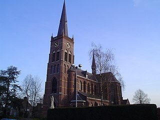
Duizel is a village in the municipality of Eersel in the province of North Brabant, the Netherlands. Duizel is part of the Acht Zaligheden, like Eersel, Knegsel, Steensel, Wintelre, Netersel, Hulsel and Reusel.
Heikant is a former hamlet in the Dutch province of North Brabant. It was located about 2 km northwest of Helvoirt.

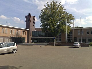
Heikant is a neighbourhood in the municipality of Veldhoven, in the Dutch province of North Brabant. With a population of over 6700 inhabitants, it is the largest neighbourhood in Veldhoven. Heikant contains a small shopping centre and a church. The Sint-Maartenchurch was built in 1990.
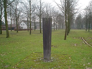
Heers is a hamlet in the south of the municipality of Veldhoven in the province of North Brabant, the Netherlands. Most of the buildings are concentrated around a town square with trees. At this town square is a chapel from 1990 located. There is also a monument, erected in 1966 for the local agricultural consolidation project. Heers has a long history. The hamlet is mentioned in books from the Middle Ages. Also, archaeological artefacts from the Bronze Age and the Roman Empire have been unearthed near the hamlet.
Zittard is a hamlet in the municipality of Veldhoven in the province of North Brabant, the Netherlands. The hamlet is located on a road with the same name and consists mostly of farms. As of 2008, Zittard has a population of 160 people.

Zandoerle, in local tongue known as Zandoers, is a hamlet in the municipality of Veldhoven in the province of North Brabant, the Netherlands. The hamlet has a population of 120 people, as measured on the first of January 2008. The hamlet is located between the villages Oerle and Knegsel. Zandoerle can be seen as one of the two centres within the village of Oerle. The other centre is often referred to as Kerkoerle . Zandoerle has great cultural and historical value due to its characteristic village green and monumental farms.

Halfmijl is a hamlet in the west of the municipality of Veldhoven in the province of North Brabant, the Netherlands. The hamlet is located two kilometers east of the village Vessem and consists of eight houses, most of which are farms.
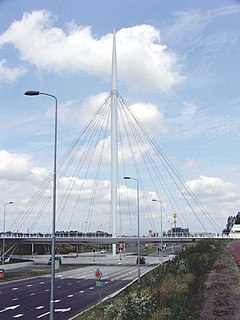
The Hovenring is a suspended cycle path roundabout in the province of North Brabant in the Netherlands. It is situated between the localities of Eindhoven, Veldhoven, and Meerhoven, which accounts for its name, and is the first of its kind in the world.

Oud Herlaer was a castle on the Dommel just east of Vught. All that remains is a farm which incorporates parts of the old castle. While not that much remains of the castle, there are a lot of recent studies about Oud Herlaer and its owners. The farm is planned to be opened as an art center in 2021. The name Oud Herlaer,, signifies that later on Nieuw-Herlaer Castle was built about 1 kilometer upstream.

Haanwijk is an estate and nature reserve with a manor house near Sint-Michielsgestel in North-Brabant, Netherlands.
