Schwanheim (Frankfurt am Main)

Last updated
Schwanheim
Wappen Frankfurt-Schwanheim02.svg
Location of Schwanheim (red) and the Ortsbezirk West (light red) within Frankfurt am Main
Frankfurt Stadtteil Schwanheim.svg
Germany adm location map.svg
Red pog.svg
Schwanheim
Hesse location map.svg
Red pog.svg
Schwanheim
Coordinates: 50°05′13″N08°34′55″E / 50.08694°N 8.58194°E / 50.08694; 8.58194
Country Germany
State Hesse
Admin. region Darmstadt
District Urban district
City Frankfurt am Main
Area
  Total17.727 km2 (6.844 sq mi)
Population
 (2020-12-31) [1]
  Total20,576
  Density1,200/km2 (3,000/sq mi)
Time zone UTC+01:00 (CET)
  Summer (DST) UTC+02:00 (CEST)
Postal codes
60528, 60529
Dialling codes 069
Vehicle registration F
Website www.schwanheim.de

Schwanheim is a quarter of Frankfurt am Main, Germany. It is part of the Ortsbezirk West and is subdivided into the Stadtbezirke Schwanheim, Goldstein-Ost and Goldstein-West.

Contents

History

Medieval Period — Early Modern Period

Schwanheim was evangelized during the early Christianization period by Irish-Scottish wandering monks. The Franconian apostle Kilian is said to have rested and preached at a flood-free ridge in the Schwanheimer Unterfeld around the year 680. The old parish church of St. Martin im Feld, which was mentioned in a document from 880, was one of the few churches on the right bank of the Rhine at the time. The church's catchment area presumably extended beyond the boundaries of the long-stretched original district of Schwanheim, which went in the west from the Mönchhof near Raunheim via Klaraberg, Kelsterbach, the Goldstein, Niederrad, and Sachsenhausen to Oberrad. However, the decline of the church began 50 years before Luther posted his theses in Wittenberg. From 1468, the people of Schwanheim celebrated their church consecration festival to the patron Saint Mauritius on the Sunday in Mauritius (September 22nd). The final end of the Martinskirche was sealed with the effects of the Reformation of 1517, which also had an impact in the local Maingau. The branch chapel of St. Mauritius with a cemetery near the old village of Schwanheim was raised to the status of a parish church and expanded between 1557 and 1562. The Martinskirche in the field was without function and fell into disrepair. It served as a quarry during the Thirty Years' War, and when the "new" church was built in the village a good hundred years later (1687), 72 wagons of stone were obtained from this ruin for the foundations of this third Schwanheim church building. From now on, Schwanheim remained true to the name Mauritius. [2]

19th Century — 21st Century

In the 19th century, Schwanheim experienced slow development from a farming village to a workers' settlement, influenced by the chemical industry in nearby areas and economic ties with Frankfurt. The village received a closer connection to the Frankfurter Waldbahn in 1889, making the previous halt on the Hessian Ludwigsbahn almost obsolete. The medical care in the village was also improved at the instigation of local seniors and the Catholic parish. Schwanheim became part of Prussia in 1866 after the war, along with the Nassau territory and Frankfurt.

In the 20th century, the construction of the first main bridge between Schwanheim and Griesheim began in 1905, and it was opened in 1907. French troops occupied a bridgehead on the right bank of the Rhine in 1918, including Schwanheim. The Allied occupation of the Rhineland lasted until 1930. Schwanheim was incorporated into the Frankfurt city area in 1928, with a population of 5,850 inhabitants and 1,793 hectares.

Construction of the Goldstein settlement began in the spring of 1932, and the Griesheim barrage was built between 1929 and 1932 as a replacement for two older needle weirs. The Schwanheim Bridge was blown up by German Wehrmacht engineers on March 26, 1945, shortly before US troops marched in. A temporary bridge was erected in 1947 and demolished in 1963 after the new Schwanheimer bridge was inaugurated. In 2005, the district celebrated its 1125th anniversary. On January 1, 2019, district 53 3 Goldstein-Ost was assigned to the Niederrad district and renamed 37 3 Niederrad-West, with the border between Schwanheim and Niederrad now running along the A5. [3]

Related Research Articles

<span class="mw-page-title-main">Hesse</span> State in Germany

Hesse or Hessia, officially the State of Hesse, is a state in Germany. Its capital city is Wiesbaden, and the largest urban area is Frankfurt, which is also the country's principal financial centre. Two other major historic cities are Darmstadt and Kassel. With an area of 21,114.73 square kilometers and a population of over six million, it ranks seventh and fifth, respectively, among the sixteen German states. Frankfurt Rhine-Main, Germany's second-largest metropolitan area, is mainly located in Hesse.

<span class="mw-page-title-main">Wiesbaden</span> Capital of Hesse, Germany

Wiesbaden is the capital of the German state of Hesse, and the second-largest Hessian city after Frankfurt am Main. With around 283,000 inhabitants, it is Germany's 24th-largest city. Wiesbaden forms a conurbation with a population of around 500,000 with the neighbouring city of Mainz. This conurbation is in turn embedded in the Rhine-Main Metropolitan Region—Germany's second-largest metropolitan region after Rhine-Ruhr—which also includes the nearby cities of Frankfurt am Main, Darmstadt, Offenbach am Main, and Hanau, and has a combined population exceeding 5.8 million.

<span class="mw-page-title-main">History of Hesse</span>

This article is about the history of Hesse. Hesse is a state in Germany.

<span class="mw-page-title-main">Zeilsheim</span> Quarter of Frankfurt am Main in Hesse, Germany

Zeilsheim is a quarter of Frankfurt am Main, Germany. It is part of the Ortsbezirk West and is subdivided into the Stadtbezirke Zeilsheim-Ost, Zeilsheim-Süd and Zeilsheim-Nord.

<span class="mw-page-title-main">Lahnstein</span> Town in Rhineland-Palatinate, Germany

Lahnstein is a verband-free town of Rhein-Lahn-Kreis in Rhineland-Palatinate, Germany. It is situated at the confluence of the Lahn with the Rhine, approximately 6 kilometres (3.7 mi) south of Koblenz. Lahnstein was created in 1969 by the merger of the previously independent towns of Oberlahnstein on the south side of the Lahn and Niederlahnstein on the north side. In 2020, it had a population of 18,030.

<span class="mw-page-title-main">Grand Duchy of Hesse</span> German state (1806–1918)

The Grand Duchy of Hesse and by Rhine was a grand duchy in western Germany that existed from 1806 to 1918. The grand duchy originally formed from the Landgraviate of Hesse-Darmstadt in 1806 as the Grand Duchy of Hesse. It assumed the name Hesse und bei Rhein in 1816 to distinguish itself from the Electorate of Hesse, which had formed from neighbouring Hesse-Kassel. Colloquially, the grand duchy continued to be known by its former name of Hesse-Darmstadt.

<span class="mw-page-title-main">Niederrad</span> Quarter of Frankfurt am Main in Hesse, Germany

Niederrad is a quarter of Frankfurt am Main, Germany. It is part of the Ortsbezirk Süd and is subdivided into the Stadtbezirke Niederrad-Nord, Niederrad-Süd and the new Niederrad-West.

<span class="mw-page-title-main">West Rhine Railway</span>

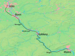
The West Rhine railway is a famously picturesque, double-track electrified railway line running for 185 km from Cologne via Bonn, Koblenz, and Bingen to Mainz. It is situated close to the western (left) bank of the river Rhine and mostly aligned to allow 160 km/h operation between Cologne and Koblenz and between Bingen and Mainz. Line speed between Koblenz and Bingen is restricted by the meandering nature of the Rhine Gorge, a UNESCO World Heritage Site.

<span class="mw-page-title-main">Vendersheim</span> Municipality in Rhineland-Palatinate, Germany

Vendersheim is an Ortsgemeinde – a municipality belonging to a Verbandsgemeinde, a kind of collective municipality – in the Alzey-Worms district in Rhineland-Palatinate, Germany.

<span class="mw-page-title-main">Taunus Railway</span> Electrified railway in central western Germany

The Taunus Railway is a double-track electrified railway line, which connects Frankfurt and Wiesbaden, Germany. It is 41.2 km long and follows the course of the Main on its north side, running quite close to it in some places. Its first stage was opened in September 1839 and is thus the oldest railway line in the German state of Hesse and one of the oldest in Germany. Today it is used by Regional-Express trains between Frankfurt and Wiesbaden and the trains of line S1 of the Rhine-Main S-Bahn between Frankfurt-Höchst and Wiesbaden. Between Frankfurt Hbf and Frankfurt-Höchst, they run on the line of the former Hessian Ludwig Railway.

The Main Railway is a 37.5 km-long double-track electrified railway line, which runs on the south side of the river Main from Mainz to Frankfurt central station.

<span class="mw-page-title-main">S1 (Rhine-Main S-Bahn)</span>

The S1 service of the S-Bahn Rhein-Main system bearing the KBS number 645.1 is an important railway connection running east–west. It operates between the Hesse state capital Wiesbaden and the southern Offenbach rural district serving the densely populated area along the Main river.

The Frankfurt Airport loop is a 15.8-kilometre-long (9.8 mi) double-track railway line connecting Frankfurt and Frankfurt Airport and operated as part of the Frankfurt S-Bahn. It is electrified at 15 kV/16.7 Hz.

<span class="mw-page-title-main">Frankfurt Stadion station</span> Railway station in Germany

Frankfurt am Main Stadion station is a junction railway station in Frankfurt, Germany.

<span class="mw-page-title-main">Frankfurt-Niederrad station</span>

Frankfurt-Niederrad station is a station in the district of Niederrad in the southwest of Frankfurt am Main in the German state of Hesse.

<span class="mw-page-title-main">Mainz rail bypass</span>

The Mainz bypass railway is a bypass around the Mainz Hauptbahnhof node primarily used for freight in the German states of Hesse and Rhineland Palatinate.

<span class="mw-page-title-main">Frankfurt-Griesheim station</span>

Frankfurt-Griesheim station is a railway station located in the Griesheim district of Frankfurt, Germany.

<span class="mw-page-title-main">Frankfurt am Main I</span> Federal electoral district of Germany

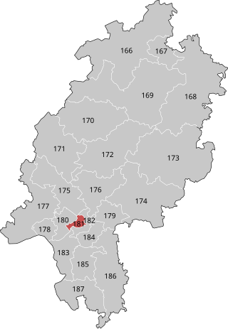
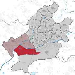
Frankfurt am Main I is an electoral constituency represented in the Bundestag. It elects one member via first-past-the-post voting. Under the current constituency numbering system, it is designated as constituency 181. It is located in southern Hesse, comprising the western part of the city of Frankfurt am Main.

The 1931–32 Eintracht Frankfurt season was the 32nd season in the club's football history. In 1931–32 the club played in the Bezirksliga Main-Hessen, then one of many top tiers of German football. It was the club's 5th season in the Bezirksliga Main-Hessen.

<span class="mw-page-title-main">Dreieich Railway</span> Rail line in Hesse, Germany

The Dreieich Railway (Dreieichbahn) is a single-track, non-electrified branch line in the Frankfurt Rhine-Main area in the German state of Hesse. It connects Dreieich-Buchschlag on the Main-Neckar Railway with Rödermark-Ober Roden on the Rodgau Railway. Colloquially, the RMV route 61 service is referred to as the Dreieichbahn, which continued beyond Ober-Roden on the Rodgau Railway to Dieburg.

References

  1. "Frankfurt Statsitik Aktuell 07/2021". Stadt Frankfurt am Main. July 2021.
  2. Kobelt, W. (1909). The won, field and path names of the district of Schwanheim (Main). Annals of the Association for Nassau Archeology and Historical Research, XXXIX
  3. Eisenbahndirektion Mainz (ed.). (1852-1920). Official Journal of the Royal Prussian and Grand Ducal Hessian Railway Directorate in Mainz. Mainz, Germany: Eisenbahndirektion Mainz.