
Hesse or Hessia, officially the State of Hesse, is a state in Germany. Its capital city is Wiesbaden, and the largest urban area is Frankfurt, which is also the country's principal financial centre. Two other major historic cities are Darmstadt and Kassel. With an area of 21,114.73 square kilometers and a population of over six million, it ranks seventh and fifth, respectively, among the sixteen German states. Frankfurt Rhine-Main, Germany's second-largest metropolitan area, is mainly located in Hesse.
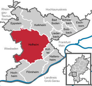
Hofheim is the administrative centre of Main-Taunus-Kreis district, in the south of the German state of Hesse. Its population in September 2020 was 39,946.
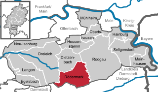
Rödermark is a town in the Offenbach district in the Regierungsbezirk of Darmstadt in Hesse, Germany, southeast of Frankfurt am Main and northeast of Darmstadt.
Heidesheim am Rhein is an Ortsbezirk (borough) of the town Ingelheim am Rhein in the Mainz-Bingen district in Rhineland-Palatinate, Germany. Before July 2019, it was a separate municipality belonging to the former Verbandsgemeinde Heidesheim am Rhein, of which it was the administrative seat. Heidesheim was one of the biggest municipalities in Rhenish Hesse.

Gelnhausen is a town, and the capital of the Main-Kinzig-Kreis, in Hesse, Germany. It is located approximately 40 kilometers east of Frankfurt am Main, between the Vogelsberg mountains and the Spessart range at the river Kinzig. It is one of the eleven towns in the district. Gelnhausen has around 22,000 inhabitants.

Rodgau is a town in the Offenbach district in the Regierungsbezirk of Darmstadt in Hesse, Germany. It lies southeast of Frankfurt am Main in the Frankfurt Rhine Main Region and has the greatest population of any municipality in the Offenbach district. It came into being in 1979 when the greater community of Rodgau was raised to town, after having been formed through a merger of five formerly self-administering communities in the framework of municipal reform in Hesse in 1977. The current constituent communities’ history reaches back to the 8th century.
The Wetterau is a fertile undulating tract, watered by the Wetter, a tributary of the Nidda River, in the western German state of Hesse, between the hilly province Oberhessen and the north-western Taunus mountains.

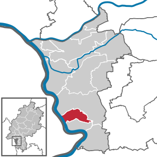
Riedstadt, with its municipal area of 73.76 km² is Groß-Gerau district's biggest town by land area. It lies in Hesse, Germany, about 12 km southwest of Darmstadt.
Bürstadt is a town in the Bergstraße district in southern Hesse, Germany, 7 km east of Worms, and 17 km north of Mannheim. In 1981, the town hosted the 21st Hessentag state festival.

Lich is a town in the district of Gießen, in Hesse, Germany. It is situated 12 km southeast of Gießen. Lich has a population of around 13,000.

Fürth is a municipality and a state-recognized recreational resort (Erholungsort) in the Bergstraße district in Hesse, Germany.
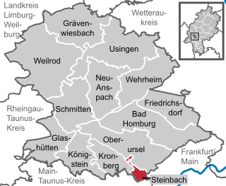
Steinbach is a town in the Hochtaunuskreis that borders Frankfurt am Main to the east. Other neighbouring towns are Oberursel, Kronberg im Taunus and Eschborn. It is in the German state of Hesse.
Stockstadt am Rhein is a municipality in Groß-Gerau district in Hesse, Germany, lying on the southern edge of the Frankfurt Rhein-Main Region.

For almost five centuries, the German city of Frankfurt was a city-state within two major Germanic entities:

Frankenstein Castle is a hilltop castle in the Odenwald overlooking the city of Darmstadt in Germany. This castle may have been an inspiration for Mary Shelley when she wrote her 1818 Gothic novel Frankenstein; or, The Modern Prometheus.

Waldems is a municipality in the Rheingau-Taunus-Kreis in the Regierungsbezirk of Darmstadt in Hesse, Germany. The municipality's administrative seat is Waldems-Esch.

Ohmbach is an Ortsgemeinde – a municipality belonging to a Verbandsgemeinde, a kind of collective municipality – in the Kusel district in Rhineland-Palatinate, Germany. It belongs to the Verbandsgemeinde of Oberes Glantal, whose seat is in Schönenberg-Kübelberg.

Nistertal is an Ortsgemeinde – a community belonging to a Verbandsgemeinde – in the Westerwaldkreis in Rhineland-Palatinate, Germany.

The House of Franckenstein is the name of a feudal, Franconian noble family in Germany, descendants from the Dynasts of the Breuberg family; offsprings of the Lords of Lützelbach from Höchst im Odenwald.

The A line is the north-to-south main line of the Frankfurt U-Bahn. It is the oldest and longest line of the U-Bahn system. Served by four routes starting at Südbahnhof Railway Station in Sachsenhausen, the A line runs through downtown Frankfurt up to Heddernheim Station in the north of the city, where it branches out to Ginnheim, Oberursel (U3), Riedberg and Bad Homburg (U2). The U9 service between Ginnheim, Riedberg and Nieder-Eschbach does not use the central section and tunnels of the line, making it the only light rail service of the network that does not serve downtown Frankfurt. The Riedberg and Ginnheim branches were planned as parts of the future D line subway but are operationally part of the A line until the D line development and construction is finished.


