Schwarzautal

Last updated
Schwarzautal
AUT Schwarzautal COA.png
Austria adm location map.svg
Red pog.svg
Schwarzautal
Location within Austria
Coordinates: 46°49′48″N15°40′48″E / 46.83000°N 15.68000°E / 46.83000; 15.68000 Coordinates: 46°49′48″N15°40′48″E / 46.83000°N 15.68000°E / 46.83000; 15.68000
Country Austria
State Styria
District Leibnitz
Government
   Mayor Alois Trummer (ÖVP)
Area
[1]
  Total39.94 km2 (15.42 sq mi)
Elevation
304 m (997 ft)
Population
 (2018-01-01) [2]
  Total2,310
  Density58/km2 (150/sq mi)
Time zone UTC+1 (CET)
  Summer (DST) UTC+2 (CEST)
Postal code
8421, 8413, 8422
Area code +43 3184
Website www.schwarzautal.gv.at
Catholic church Pfarrkirche hl. Dionysius and cemetery in Wolfsberg im Schwarzautal. Wolfsberg im Schwarzautal IMG 3447.jpg
Catholic church Pfarrkirche hl. Dionysius and cemetery in Wolfsberg im Schwarzautal.

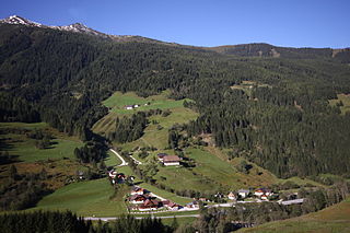
Schwarzautal is a market town since 2015 with 2,299 residents (as of 1 January 2016) in the Leibnitz District of Styria, Austria.

Contents

The municipality was founded as part of the Styria municipal structural reform, [3] at the end of 2014, by merging the five former towns: Schwarzau im Schwarzautal, Wolfsberg im Schwarzautal, Breitenfeld am Tannenriegel, Hainsdorf im Schwarzautal and Mitterlabill. [4]

The towns Mitterlabill and Schwarzau im Schwarzautal lied in the political district Südoststeiermark, while the other towns lied in the district of Leibnitz. The boundaries of the districts and the judicial districts have been changed so that the new community is now fully in the district and jurisdiction Leibnitz. [5]

Until the end of 2012 the former municipalities Mitterlabill and Schwarzau im Schwarzautal lied in the Feldbach District and had the indicating plate letters "FB". From mid-2013 until the end of 2014, the letters "SO" were assigned, since 2015 "LB" indicates the Leibnitz district.

Geography

Municipality arrangement

The municipality territory includes nine Katastralgemeinden and 12 towns (populations and areas as of January 2015 [6] ):

Katastralgemeinden
  • Breitenfeld (445.95 ha or 1,102.0 acres)
  • Hainsdorf (431.40 ha)
  • Maggau (517.50 ha)
  • Marchtring (334.34 ha)
  • Matzelsdorf (237.19 ha)
  • Mitterlabill (495.21 ha)
  • Schwarzau (538.45 ha)
  • Unterlabill (297.06 ha or 734.1 acres)
  • Wolfsberg (723.82 ha or 1,788.6 acres)
Town

Neighboring municipalities

The municipality is enclosed by ten neighboring communities, four of them lie in the Südoststeiermark District  (SO).

Demographics

Schwarzautal

Politics

Mayor

Alois Trummer (ÖVP) was elected in the inaugural meeting of the Municipal Council in April 2015 as mayor of the new municipality. [7]

The municipal council further includes the Deputy Mayor Martin Kohl (ÖVP) and the municipality treasurer Rupert Wahrlich (Schwarzautal Active - List Rupert Wahrlich). [8]

Municipal council

The municipal council consists of 15 members. According to the results of the municipal elections in 2015, the seat allocation is as follows:

The prior elections had the following results:

Party20152010
SchwarzautalSchwarzau
im Schwarz.
BreitenfeldHainsdorfMitterlabillWolfsberg
im Schwarz.
Votes %SeatsV. %S.V. %S.V. %S.V. %S.V. %S.
ÖVP 7954983801009137100919110092871009252414
SPÖ 6640not contested83131
FPÖ 14591not contested
Schwarzautal Aktiv
Liste Rupert Wahrlich
631396not contested286464
Counts1,974536174247367678
Percentage84%76%81%81%82%93%
All percents are based on the total count.

Coat of arms

AUT Schwarzautal COA.png

Four of the five predecessor towns had a town crest. Because of the merger, they lost their official validity on January 1, 2015. The authorization of the municipal coat of arms, for the fusion community, was carried out with effect from 15 July 2016.
Blazon (crest description):

"A black, silver-flooded hive, cut in from the upper edge of the shield, in red on each side a three-leafed, seven-beaded silver meadowspowder, and in green center are three (1:2) similar plants". [9]

Culture and sights

Chapel in Schwarzau im Schwarzautal Kapelle 42175 in A-8421 Schwarzau.jpg
Chapel in Schwarzau im Schwarzautal

Related Research Articles

Bezirk Leibnitz is a district of the state of Styria in Austria. Since the 2015 Styria municipal structural reform, it consists of the following municipalities:

Oberwölz Place in Styria, Austria

Oberwölz is a city since 2015 in the Murau District of Styria, Austria. The city was founded as part of the Styria municipal structural reform, at the end of 2014, with the merger of the former independent municipalities Oberwölz Stadt, Oberwölz Umgebung, Schönberg-Lachtal and Winklern bei Oberwölz, whereby the new municipality became ranked as a city ("Stadtgemeinde").

Geistthal-Södingberg Place in Styria, Austria

Geistthal-Södingberg is, since the beginning of 2015, a municipality within Voitsberg, Styria. The municipality of Geistthal-Södingberg was created as part of the Steiermärkische Gemeindestrukturreform in Styria, which combined Geistthal and Södingberg.

Aflenz Place in Styria, Austria

Aflenz is since January 2015 a new market town with 2,421 residents in Bruck-Mürzzuschlag District of Styria, Austria.

Sankt Georgen am Kreischberg Place in Styria, Austria

Sankt Georgen am Kreischberg is since 2015 a municipality in Murau District in Styria, Austria. It was created as part of the Styria municipal structural reform, out of the former independent towns Sankt Georgen ob Murau and Sankt Ruprecht-Falkendorf. The town church after the changes, which began in November 2013, had continued the name "Sankt Georgen ob Murau", which was corrected through an amendment in April 2014.

Söding-Sankt Johann Place in Styria, Austria

Söding-Sankt Johann is since 2015 a municipality with 4,043 residents in Voitsberg District in Styria, Austria.

Kirchbach-Zerlach Place in Styria, Austria

Kirchbach-Zerlach is since 2015 a municipality with 3,271 residents in the Südoststeiermark District of Styria, Austria. In 2015 the municipality was called Kirchbach in der Steiermark.

Feistritztal Place in Styria, Austria

Feistritztal is since 2015 a municipality in Hartberg-Fürstenfeld District in Styria, Austria.

Ehrenhausen an der Weinstraße Place in Styria, Austria

Ehrenhausen an der Weinstraße is a municipality with 2,623 residents in the Leibnitz District of Styria, Austria.

Gutenberg-Stenzengreith Place in Styria, Austria

Gutenberg-Stenzengreith is a municipality since 2015 in the Weiz District of Styria, Austria. It was created as part of the Styria municipal structural reform, at the end of 2014, by merging the former towns of Gutenberg an der Raabklamm and Stenzengreith.

Irdning-Donnersbachtal Place in Styria, Austria

Irdning-Donnersbachtal is a new municipality since January 2015 with 4,137 residents in the Liezen District of Styria, Austria.

Leutschach an der Weinstraße Place in Styria, Austria

Leutschach an der Weinstraße is since January 2015 a new municipality with 3,794 residents in the Leibnitz District of Styria, Austria.

Mitterberg-Sankt Martin Place in Styria, Austria

Mitterberg-Sankt Martin is a municipality since 2015 in the Expositur Gröbming in the Liezen District of Styria, Austria.

Pöls-Oberkurzheim Place in Styria, Austria

Pöls-Oberkurzheim is a municipality since 2015 in the Murtal District of Styria, Austria.

Sankt Veit in der Südsteiermark Place in Styria, Austria

Sankt Veit in der Südsteiermark is a municipality since 2015 in the Leibnitz District of Styria, Austria. The population was 4,069 residents.

Seiersberg-Pirka Place in Styria, Austria

Seiersberg-Pirka is a municipality with 10,746 residents, and after Gratwein-Straßengel, the 2nd-largest municipality of Graz-Umgebung District in Styria, Austria.

Sölk Place in Styria, Austria

Sölk is a municipality since 2015 in the Liezen District of Styria, Austria.

Stadl-Predlitz Place in Styria, Austria

Stadl-Predlitz is a municipality since 2015 in the Murau District of Styria, Austria.

Stainach-Pürgg Place in Styria, Austria

Stainach-Pürgg is a municipality since 2015 in the Liezen District of Styria, Austria.

Teufenbach-Katsch Place in Styria, Austria

Teufenbach-Katsch is a municipality since 2015 in the Murau District of Styria, Austria.

References

  1. "Dauersiedlungsraum der Gemeinden Politischen Bezirke und Bundesländer - Gebietsstand 1.1.2018". Statistics Austria. Retrieved 10 March 2019.
  2. "Einwohnerzahl 1.1.2018 nach Gemeinden mit Status, Gebietsstand 1.1.2018". Statistics Austria. Retrieved 9 March 2019.
  3. Steiermärkische Gemeindestrukturreform.
  4. Kundmachung der Steiermärkischen Landesregierung vom 3. Oktober 2013 über die Vereinigung der Marktgemeinde Wolfsberg im Schwarzautal und der Gemeinden Breitenfeld am Tannenriegel, Hainsdorf im Schwarzautal, alle politischer Bezirk Leibnitz, und der Gemeinden Mitterlabill und Schwarzau im Schwarzautal, beide politischer Bezirk Südoststeiermark. Landesgesetzblatt für die Steiermark vom 26. Juni 2014. Nr. 75, Jahrgang 2014. ZDB-ID   705127-x. p. 1.
  5. Verordnung der Steiermärkischen Landesregierung vom 10. Juli 2014, mit der die Steiermärkische Bezirkshauptmannschaftenverordnung geändert wird. Landesgesetzblatt für die Steiermark. 10 September 2014. Nr. 99 Jahrgang 2014. ZDB-ID   705127-x.
  6. Einwohner nach Ortschaften (Excel-Datei, 766 KB); accessed on 29 July 2015
  7. Gemeinde Schwarzautal: Bürgermeister, accessed on 15 June 2015
  8. Gemeinde Schwarzautal: Gemeindevorstand, accessed on 15 June 2015
  9. 94. Verlautbarung der Steiermärkischen Landesregierung vom 30. Juni 2016 über die Verleihung des Rechtes zur Führung eines Gemeindewappens an die Marktgemeinde Schwarzautal (politischer Bezirk Leibnitz), accessed on 28 October 2016.