
The Zugspitze, at 2,962 m (9,718 ft) above sea level, is the highest peak of the Wetterstein Mountains as well as the highest mountain in Germany. It lies south of the town of Garmisch-Partenkirchen, and the Austria–Germany border runs over its western summit. South of the mountain is the Zugspitzplatt, a high karst plateau with numerous caves. On the flanks of the Zugspitze are three glaciers, including the two largest in Germany: the Northern Schneeferner with an area of 30.7 hectares and the Höllentalferner with an area of 24.7 hectares. The third is the Southern Schneeferner which covers 8.4 hectares.
The Ester Mountains are a small mountain range in Bavaria. They are classified either as part of Bavarian Prealps or the larger chain of Northern Limestone Alps. The range stretches for about 15 kilometres. From the west it is bordered by the valley of the river Loisach and from the east by Walchensee lake and the valley of the river Isar. With its highest peak being Krottenkopf, the highest part of the range just exceeds 2,000 m. The range is of composed of limestone. The treeline is around 1,700 m.

The Wetterstein mountains, also simply called the Wetterstein, is a mountain group in the Northern Limestone Alps within the Eastern Alps. It is a relatively compact range located between Garmisch-Partenkirchen, Mittenwald, Seefeld in Tirol and Ehrwald. Part of it is in the German free state of Bavaria and part in the Austrian federal state of Tyrol. The main summit of the Wetterstein, the Zugspitze, is also the highest mountain in Germany.

The Kaiser Mountains or just Kaiser, are a mountain range in the Northern Limestone Alps and Eastern Alps. It consists of two main mountain ridges – the Zahmer Kaiser to the north and the Wilder Kaiser to the south. The entire range is situated in the Austrian state of Tyrol between the town of Kufstein and the market town of St. Johann in Tirol. The Kaiser Mountains offer some of the loveliest scenery in all the Northern Limestone Alps.
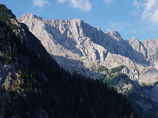
The Höllentalspitzen are three peaks in the Wetterstein Mountains near Garmisch-Partenkirchen in southern Germany. They rise from the ridge of Blassenkamm which runs eastwards from Germany's highest peak, the Zugspitze, and separate the Hölle Valley to the north from the Reintal Valley to the south. The summit nearest to the Zugspitze is the Inner Höllentalspitze, 2,741 metres (8,993 ft) high; this is followed by the main summit Middle Höllentalspitze, 2,743 metres (8,999 ft) high; and the Outer Höllentalspitze at 2,720 metres (8,920 ft).

The Wetterspitzen are three of the rocky peaks on a mountain ridge in the Wetterstein mountains in the central part of the Eastern Alps in Germany. They lie two kilometres, as the crow flies, southwest of Germany's highest peak, the Zugspitze, on the border between the Austrian province of Tyrol and the German state of Bavaria. The Wetterspitzen form the southwest perimeter of the Zugspitze ledge (Zugspitzplatt); below and to the east is the ski region on the Schneeferner with its research station, the Schneefernerhaus.

The Schneefernerkopf is a 2,875-metre-high (9,432 ft) peak in the Zugspitze massif in the Alps. It lies at the western end of the Wetterstein chain in the Alps on the border between the German state of Bavaria and the Austrian state of Tyrol. It is the dominant mountain in the Wetterstein, especially when viewed from Ehrwald.
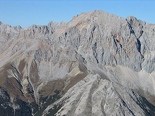
At 2,744 metres (9,003 ft), the Hochwanner is the second highest mountain in Germany after the Zugspitze. In addition the Hochwanner is the highest peak on the main ridge of the Wetterstein (Wettersteinhauptkamm) running from Gatterl to the Upper Wettersteinspitze above Mittenwald in an east-west direction. From the Hochwanner massif there is an all-round view of the Rein valley (Reintal), the Leutasch valley in Austria, the Gais valley, the Zugspitze, the Mieming Chain, the Jubiläumsgrat, the Karwendel mountains and far into the central Alps.

Hermann von Barth was a famous German mountaineer.

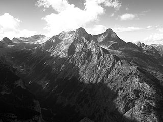
Dreitorspitze is a large and very prominent, multi-peak mountain massif in the eastern part of the Wetterstein Mountains in southern Germany. It is divided into Partenkirchen Dreitorspitze at 2,633 metres (8,638 ft) and Leutasch Dreitorspitze at 2,682 metres (8,799 ft); each of which has several peaks. The main peak of the fourth highest mountain massif in Germany is the Leutasch Dreitorspitze, which is also known as the Karlspitze. The Dreitorspitze marks the spot where the main chain of the Wetterstein mountains changes direction from its primary east-west orientation to run northwards for a short distance, before turning back again onto its main axis. East of the Dreitorspitze lies the karst plateau of the Leutasch Platt, comparable to the Zugspitzplatt at the foot of the Zugspitze.
The Hochblassen is a mountain 2,706 metres (8,878 ft) high, located in the Wetterstein in the German state of Bavaria. In addition to the main summit, it has a sub-peak, the so-called Signalgipfel which is 2,698 metres (8,852 ft) high. It was first climbed in 1871 by Hermann von Barth and Peter Klaisl.

The Alpspitze is a mountain, 2,628 m, in Bavaria, Germany. Its pyramidal peak is the symbol of Garmisch-Partenkirchen and is one of the best known and most attractive mountains of the Northern Limestone Alps. It is made predominantly of Wetterstein limestone from the Upper Triassic.
The Hinterreintalschrofen is a 2,669 m high peak on the main, east-west oriented crest of the Wetterstein Mountains in the Eastern Alps. It is a massive and dominant mountain with a high rock face that plunges into the Reintal valley to the north and stamps the appearance of the Wetterstein when seen from the north. In spite of that, the mountain is rarely climbed. Its neighbouring peaks are the Hochwanner (2,746 m) to the west and the Hundstallköpfe (2,533 m) to the east. The Teufelsgrat runs along the national border between the Austrian state of Tyrol, (Gaistal) in the south and the German state of Bavaria, (Reintal) in the north.

The Östliche Karwendelspitze is a mountain formed from Wetterstein limestone in the Karwendel mountains on the border between Bavaria and Tyrol. It is the highest mountain of the Northern Karwendel chain and the highest German peak in the Karwendel. It was first climbed by Hermann von Barth on 4 July 1870.

The Plattspitzen is a 2,680 metre high mountain in the Wetterstein Mountains on the border between Germany and Austria. It is a very striking mountain and the southern companion of Germany's highest peak, the Zugspitze, located at the opposite end of the ledge known as the Plattumrahmung. The mountain has three summits: the eastern summit, known as the Gatterlspitz, the middle summit and the western summit. It was first climbed in 1871 by Hermann von Barth, who conquered all three peaks alone departing from the Zugspitzplatt ledge. At that time the mountain was also known as the Wetterschrofen.
The Mieming(er) Range, Mieminger Chain or Mieminger Mountains, is a mountain range of the Northern Limestone Alps in the Eastern Alps. It is located entirely in Austria within the state of Tyrol. This sub-group is somewhat in the shadows of its more famous neighbour, the Wetterstein to the north. Whilst the region around the Coburger Hut and the lakes of Seebensee and Drachensee in the west and the Hohe Munde in the extreme east receive large numbers of visitors, the less developed central area remains very quiet. The Hohe Munde is also a popular and challenging ski touring destination.

The Riffelwandspitzen are two adjacent mountains in the Wetterstein range in Bavaria. The summit of the Great Riffelwandspitze reaches a height of 2,626 m, the summit of the Little Riffelwandspitze2,543 m.

The Riffelspitzen are two neighbouring peaks in the Wetterstein range in Bavaria. The Southern Riffelspitze is 2,263 m high; the Northern Riffelspitze attains 2,242 m.

The Hohe Munde is a 2,662-metre-high (8,734 ft) mountain at the eastern end of the Mieming Chain in the Austrian state of Tyrol. It has two peaks: the west top (2,662 m) and the east top or Mundekopf (2,592 m).


