
The Scottish Borders is one of 32 council areas of Scotland. It borders the City of Edinburgh, Dumfries and Galloway, East Lothian, Midlothian, South Lanarkshire, West Lothian and, to the south-west, south and east, the English counties of Cumbria and Northumberland. The administrative centre of the area is Newtown St Boswells.

Melrose is a small town and civil parish in the Scottish Borders, historically in Roxburghshire. It lies within the Eildon committee area of Scottish Borders Council.

The A68 is a major road in the United Kingdom, running from Darlington in England to the A720 in Edinburgh.

St Mary's Abbey, Melrose is a partly ruined monastery of the Cistercian order in Melrose, Roxburghshire, in the Scottish Borders. It was founded in 1136 by Cistercian monks at the request of King David I of Scotland and was the chief house of that order in the country until the Reformation. It was headed by the abbot or commendator of Melrose. Today the abbey is maintained by Historic Environment Scotland as a scheduled monument.
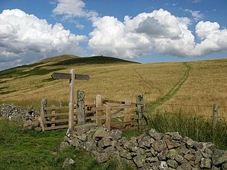
Eildon is the largest committee area of the Scottish Borders Council, with a population of 34,892 at the census in 2001. It also contains the three Eildon Hills, tallest in the Scottish Borders.
St Cuthbert's Way is a 100-kilometre (62 mi) long-distance trail between the Scottish Borders town of Melrose and Lindisfarne off the coast of Northumberland, England. The walk is named after Cuthbert, a 7th-century saint, a native of the Borders who spent his life in the service of the church. The route links Melrose Abbey, where Cuthbert began his religious life, with his initial burial place on Holy Island. Cuthbert achieved the status of bishop, and was called a saint eleven years after his death, when his coffin was opened and his remains found to be perfectly preserved.

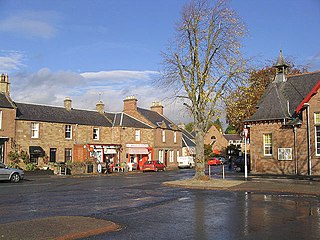
Earlston is a civil parish and market town in the county of Berwickshire, within the Scottish Borders. It is on the River Leader in Lauderdale, Scotland.

Dryburgh is a village in the Borders region of Scotland, within the county of Berwickshire. It is most famous for the ruined Dryburgh Abbey.
St Boswells is a large village on the south side of the River Tweed in the Scottish Borders, about 1 mile southeast of Newtown St Boswells on the A68 road. It lies within the boundaries of the historic county of Roxburghshire.

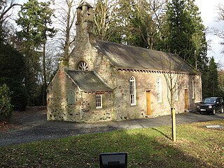
Bemersyde House is a historic house in Roxburghshire, Scotland.

Lauderdale is a long narrow geographical district in the Scottish Borders, Scotland, being the valley of the Leader Water,, above which rivulet St. Cuthbert had a vision of St. Aidan's soul being conducted to heaven. It is traversed from end to end by the A68 trunk road which runs from Darlington to Edinburgh.

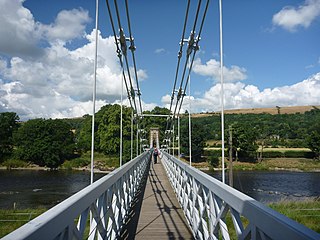
The River Leader, or Leader Water, is a small tributary of the River Tweed in Lauderdale in the Scottish Borders. It flows southwards from the Lammermuir Hills through the towns of Lauder and Earlston, joining the River Tweed at Leaderfoot.

Bemersyde is a hamlet in the Mertoun parish of Berwickshire, in the Scottish Borders. It sits on the left bank of the River Tweed, about three miles east of Melrose. Bemersyde House, the ancestral home of the Haig family, is the most notable feature.

The William Wallace Statue near the grounds of the Bemersyde estate, near Melrose in the Scottish Borders is a statue commemorating William Wallace. It was commissioned by David Steuart Erskine, 11th Earl of Buchan, and it protected as a category B listed building.

Darnick is a village near Melrose in the Scottish Borders area of Scotland, in the former Roxburghshire. The name was first recorded in 1124, and has changed from Dernewic, Dernwick and Darnwick to the present Darnick. Darnick Tower was built in c. 1425, and another tower house, Fisher's Tower, is still recognisable by its remains.

Clintmains is a village by the River Tweed, in the parish of Mertoun, to the east of Newtown St Boswells, in the Scottish Borders area of Scotland, in the former county of Berwickshire.
Gattonside is a small village in the Scottish Borders. It is located 1 kilometre (0.62 mi) north of Melrose, on the north side of the River Tweed. In 1143, the lands of Gattonside were granted to the monks of Melrose Abbey by King David I.
Mertoun is a parish in the south-west of the historic county of Berwickshire in the Scottish Borders area of Scotland. Together with the parish of Maxton, Roxburghshire it forms the Maxton and Mertoun Community Council area. It was included in the former Ettrick and Lauderdale District of Borders Region, by the Local Government (Scotland) Act 1973, from 1975 to 1996.

