
Lake Pontchartrain is a brackish estuary located in southeastern Louisiana in the United States. It covers an area of 630 square miles (1,600 km2) with an average depth of 12 to 14 feet. Some shipping channels are kept deeper through dredging. It is roughly oval in shape, about 40 miles (64 km) from west to east and 24 miles (39 km) from south to north.

The Ninth Ward or 9th Ward is a distinctive region of New Orleans, Louisiana, which is located in the easternmost downriver portion of the city. It is geographically the largest of the 17 Wards of New Orleans. On the south, the Ninth Ward is bounded by the Mississippi River. On the western or "upriver" side, the Ninth Ward is bounded by Franklin Avenue, then Almonaster Avenue, then People's Avenue. From the north end of People's Avenue the boundary continues on a straight line north to Lake Pontchartrain; this line is the boundary between the Ninth and the city's Eighth Ward. The Lake forms the north and northeastern end of the ward. St. Bernard Parish is the boundary to the southeast, Lake Borgne farther southeast and east, and the end of Orleans Parish to the east at the Rigolets.
The Pontchartrain Expressway is a parallel six-lane section of Interstate 10 (I-10) and U.S. Route 90 Business in New Orleans, Louisiana, USA, with a brief stand-alone section in between junctions with these highways. The designation begins on I-10 near the Orleans–Jefferson parish line at the I-610 Split. The expressway follows I-10 into the Central Business District (CBD) of New Orleans and then follows US 90 Bus. to the Crescent City Connection. The expressway takes its name from Pontchartrain Boulevard, which the expressway replaced in some areas. The Pontchartrain name is derived from Lake Pontchartrain, which New Orleans' northern border traverses.

The Industrial Canal is a 5.5 mile (9 km) waterway in New Orleans, Louisiana, United States. The waterway's proper name, as used by the U.S. Army Corps of Engineers and on NOAA nautical charts, is Inner Harbor Navigation Canal (IHNC). The more common "Industrial Canal" name is used locally, both by commercial mariners and by landside residents.

The 17th Street Canal is the largest and most important drainage canal in the city of New Orleans. Operating with Pump Station 6, it moves water into Lake Pontchartrain. The canal, along with the Orleans Canal and the London Avenue Canal, form the New Orleans Outfall Canals. The 17th Street Canal forms a significant portion of the boundary between the city of New Orleans and Metairie, Louisiana. The canal has also been known as the Metairie Outlet Canal and the Upperline Canal.

The London Avenue Canal is a drainage canal in New Orleans, Louisiana, used for pumping rain water into Lake Pontchartrain. The canal runs through the 7th Ward of New Orleans from the Gentilly area to the Lakefront. It is one of the three main drainage canals responsible for draining rainwater from the main basin of New Orleans. The London Avenue Canal's flood walls built atop earthen levees breached on both sides during Hurricane Katrina in 2005.

Though Hurricane Katrina did not deal the city of New Orleans a direct hit on August 29, 2005, the associated storm surge precipitated catastrophic failures of the levees and flood walls. The Mississippi River Gulf Outlet ("MR-GO") breached its levees in approximately 15 places. The major levee breaches in the city include the 17th Street Canal levee, the London Avenue Canal, and the wide, navigable Industrial Canal, which left approximately 80% of the city flooded.
On Monday, August 29, 2005, there were over 50 failures of the levees and flood walls protecting New Orleans, Louisiana, and its suburbs following passage of Hurricane Katrina and landfall in Mississippi. The levee and flood wall failures caused flooding in 80% of New Orleans and all of St. Bernard Parish. Tens of billions of gallons of water spilled into vast areas of New Orleans, flooding over 100,000 homes and businesses. Responsibility for the design and construction of the levee system belongs to the United States Army Corps of Engineers; the responsibility of maintenance belongs to the local levee boards. The Corps hands components of the system over to the local levee boards upon completion. When Katrina struck on August 29, 2005, the project was between 60–90% complete. Four major investigations were conducted by civil engineers and other experts in an attempt to identify the underlying reasons for the failure of the federal flood protection system. All concur that the primary cause of the flooding was inadequate design and construction by the Army Corps of Engineers.
Drainage in New Orleans, Louisiana, has been a major concern since the founding of the city in the early 18th century, remaining an important factor in the history of New Orleans today. The central portion of metropolitan New Orleans is fairly unusual in that it is almost completely surrounded by water: Lake Pontchartrain to the north, Lake Borgne to the east, wetlands to the east and west, and the Mississippi River to the south. Half of the land area between these bodies of water is at or below sea level, and no longer has a natural outlet for flowing surface water. As such, virtually all rainfall occurring within this area must be removed through either evapotranspiration or pumping. Thus, flood threats to metropolitan New Orleans include the Mississippi River, Lake Pontchartrain, canals throughout the city, and natural rainfall. Artificial levees have been built to keep out rising river and lake waters but have had the negative effect of keeping rainfall in, and have failed on numerous occasions.

The Florida Avenue Bridge is a vertical lift bridge spanning the Industrial Canal in New Orleans, Louisiana. The bridge has one railroad track, two vehicle lanes and two sidewalks. A parallel high-elevation four-lane roadway bridge is planned.

The 8th Ward is a section of New Orleans, Louisiana. It is one of the Downtown Wards of New Orleans, with a Creole history.
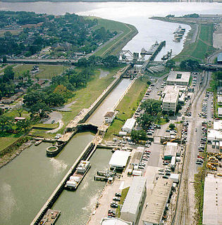
The Inner Harbor Navigation Canal Lock—commonly known as Industrial Canal Lock or simply Industrial Lock—is a navigation lock in New Orleans. It connects the Lower Mississippi River to the Industrial Canal and other sea-level waterways. Because it is shorter and narrower than most modern locks on the Mississippi River System, the 1920s vintage lock has become a bottleneck between the nation's two highest-tonnage waterways—the Mississippi and the Gulf Intracoastal Waterway.

Elysian Fields Avenue is a broad, straight avenue in New Orleans named after the Avenue des Champs-Élysées in Paris. It courses south to north from the Lower Mississippi River to Lake Pontchartrain, a distance of approximately 5 miles (8.0 km). The avenue intersects with Interstate 610, Interstate 10, and U.S. Highway 90, Gentilly Boulevard passing by Brother Martin High School. The part between North Claiborne Avenue and Gentilly Boulevard is Louisiana Highway 3021 ; the piece from N. Claiborne Avenue south to St. Claude Avenue carries Louisiana Highway 46.
U.S. Highway 90 Business is a business route of U.S. Highway 90 located in and near New Orleans, Louisiana. It runs 14.25 miles (22.93 km) in a general east–west direction from US 90 in Avondale to a junction with Interstate 10 (I-10) and US 90 in the New Orleans Central Business District.

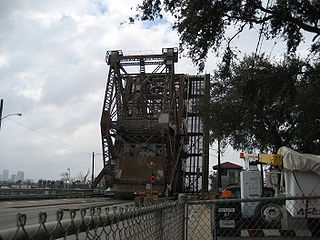
The Claiborne Avenue Bridge, officially known as the Judge William Seeber Bridge, is a vertical lift bridge in New Orleans, Louisiana over the Industrial Canal. It was built by the Louisiana Department of Highways and opened to vehicular traffic in 1957. The bridge has suffered numerous disasters: A barge hit the bridge in 1993, Hurricane Katrina damaged it in 2005, and a car plunged into the canal in 2008 due to a malfunction.
The St. Claude Avenue Bridge is a bascule bridge with four vehicular lanes over the Industrial Canal in New Orleans, Louisiana. The bridge was designed by the Strauss Bascule Bridge Company of Chicago and built in 1919 by the Bethlehem Steel Bridge Corporation. It was originally a combination railroad and automobile bridge, with two pairs of railroad tracks in the center of the lift span and automobile lanes straddling it. The railroad is no longer there, its place on the bridge taken by additional vehicular lanes. One lane in each direction passes through the truss of the bridge and one lane passes alongside the truss. The bridge is integrated into the Industrial Canal Lock structure, on the river side of the lock chamber; it raises when marine traffic enters or exits the lock.

The Almonaster Avenue Bridge is a bascule bridge in New Orleans, Louisiana. The bridge has two vehicular lanes of Almonaster Avenue and two railroad tracks over the Industrial Canal.

The Seabrook Bridge is a medium-rise twin bascule, four-lane roadway bridge in New Orleans, Louisiana, carrying Lakeshore Drive, connecting Leon C. Simon Drive on the upper side of the bridge with Hayne Boulevard on the lower side. The bridge is operated by the Orleans Levee District. It normally stays in the down position for vehicular traffic, but provides sufficient clearance for most marine traffic.

The Bahia Honda Rail Bridge is a derelict railroad bridge in the lower Florida Keys connecting Bahia Honda Key with Spanish Harbor Key. It was originally part of the Overseas Railway, but the state of Florida purchased it from the Florida East Coast Railway (FEC) after the 1935 Labor Day Hurricane and converted it for automobile use as part of the Overseas Highway in 1938. After a replacement Bahia Honda Bridge was opened in 1972, two spans of the old bridge were removed for the safety of boat traffic and to prevent pedestrian access to unsafe parts of the bridge.

The Inner Harbor Navigation Canal (IHNC) Seabrook Floodgate Structure is a flood barrier in the Industrial Canal in New Orleans, Louisiana. The floodgate is designed to protect the Industrial Canal and the surrounding areas from a storm surge from Lake Pontchartrain. It consists of two 50-foot (15 m) wide vertical lift gates and a 95-foot (29 m) wide sector gate.

