
Lake Illawarra, an open and trained intermediate wave dominated barrier estuary or large coastal lagoon, is located in the Illawarra region of New South Wales, situated about 100 kilometres (62 mi) south of Sydney, Australia.

Flinders Island, the largest island in the Furneaux Group, is a 1,367-square-kilometre (528 sq mi) island in the Bass Strait, northeast of the island of Tasmania. Flinders Island is part of the state of Tasmania, Australia. It is 54 kilometres (34 mi) from Cape Portland and is located on 40° south, a zone known as the Roaring Forties.
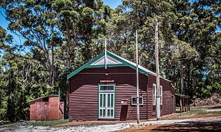
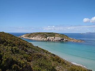
Torbay is a small town and a bay in the Great Southern region of Western Australia, 20 kilometres (12 mi) west of Albany. Torbay is within the City of Albany local government area. The Torbay townsite was gazetted in 1910.
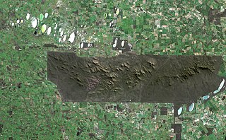
The Stirling Range or Koikyennuruff is a range of mountains and hills in the Great Southern region of Western Australia, 337 kilometres (209 mi) south-east of Perth. It is over 60 kilometres (37 mi) wide from west to east, stretching from the highway between Mount Barker and Cranbrook eastward past Gnowangerup. The Stirling Range is protected by the Stirling Range National Park, which was gazetted in 1913, and has an area of 1,159 km2 (447 sq mi).

King George Sound is the name of a sound on the south coast of Western Australia. Originally named King George the Third's Sound, it was referred to as King George's Sound from 1805. The name "King George Sound" gradually came into use from about 1934, prompted by new Admiralty charts supporting the intention to eliminate the possessive 's' from geographical names.
St Alouarn Islands are a group of islands and rocks south-east of Cape Leeuwin in Western Australia, approximately 11 km south of Augusta in Flinders Bay.
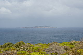
Eclipse Island is a barren island in Western Australia, 17 kilometres (10.6 mi) due south of Albany, and 6.1 km (3.8 mi) south of the nearest point of the mainland coast, which is Cave Point on the southern coast of Torndirrup Peninsula. Eclipse Island Lighthouse is located near the centre of the island. Nearby South West Island contains Western Australia's southernmost landmass.
Cape Howe is a coastal headland in eastern Australia, forming the south-eastern end of the Black-Allan Line, a portion of the border between New South Wales and Victoria. Cape Howe was also the original name of West Cape Howe, a coastal headland near Albany, Western Australia that forms the westernmost extent of the Great Australian Bight.

The City of Albany is a local government area in the Great Southern region of Western Australia, about 410 kilometres (255 mi) south-southeast of Perth, the capital of Western Australia. It covers an area of 4,312.3 square kilometres (1,665 sq mi), including the Greater Albany metropolitan area and the Port of Albany, as well as the surrounding agricultural district and some national parks. The City of Albany had a population of over 36,000 at the 2016 census.
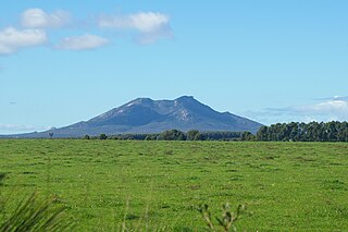
Mount Manypeaks is a distinctive peak located approximately 35 kilometres (22 mi) north-east of Albany, Western Australia, 10 kilometres (6 mi) north-east of Two Peoples Bay and 6 km south-east of the town of Manypeaks in the City of Albany local government area.

The King River is a river in the Great Southern region of Western Australia.

Michaelmas Island is an island located in King George Sound near Albany, Western Australia.
Breaksea Island in King George Sound in the Great Southern region of Western Australia is 12 kilometres (7 mi) south-east of Albany.
Shelter Island is approximately 20 kilometres (12 mi) due west of Albany, Western Australia.

Green Island is an island in Oyster Harbour located approximately 6.5 kilometres (4 mi) northeast of Albany in Western Australia.

Mistaken Island is an island located approximately 5 kilometres (3 mi) south-east of Albany, Western Australia.
Princess Royal Harbour is a part of King George Sound on the South coast of Western Australia, and harbour to Albany. On its northern shore is the Port of Albany. The name Princess Royal also appears in Albany in Princess Royal Fortress and Princess Royal Drive.

Vancouver's Cairn is a cairn located on Point Possession, Vancouver Peninsula, overlooking Princess Royal Harbour approximately 5 kilometres (3 mi) south of Albany in the Great Southern region of Western Australia.
Doubtful Islands are a group of three small islands located approximately 3 kilometres (2 mi) offshore of Point Hood and approximately 20 kilometres (12 mi) east of Bremer Bay in Western Australia.

County of Carnarvon is a cadastral unit located in the Australian state of South Australia which covers the full extent of Kangaroo Island. It was proclaimed in 1874 by Governor Musgrave in response to the demand for agriculture land on Kangaroo Island.

