
The Limpopo River rises in South Africa, and flows generally eastwards through Mozambique to the Indian Ocean. The term Limpopo is derived from Rivombo (Livombo/Lebombo), a group of Tsonga settlers led by Hosi Rivombo who settled in the mountainous vicinity and named the area after their leader. The river is approximately 1,750 kilometres (1,087 mi) long, with a drainage basin 415,000 square kilometres (160,200 sq mi) in size. The mean discharge measured over a year is 170 m3/s at its mouth. The Limpopo is the second largest river in Africa that drains to the Indian Ocean, after the Zambezi River.

Polokwane, also known by its former name, Pietersburg, is a city and the capital of the Limpopo Province of South Africa. It is South Africa's largest urban centre north of Gauteng. Polokwane was one of the host cities of the 2010 FIFA World Cup.

The Drakensberg is the eastern portion of the Great Escarpment, which encloses the central Southern African plateau. The Great Escarpment reaches its greatest elevation – 2,000 to 3,482 metres within the border region of South Africa and Lesotho.

Veld, also spelled veldt, is a type of wide open rural landscape in Southern Africa. Particularly, it is a flat area covered in grass or low scrub, especially in the countries of South Africa, Lesotho, Eswatini, Zimbabwe and Botswana. A certain sub-tropical woodland ecoregion of Southern Africa has been officially defined as the Bushveld by the World Wide Fund for Nature. Trees are found only in a few places—frost, fire and grazing animals allow grass to grow but prevent the growth of trees.

Kruger National Park is a South African National Park and one of the largest game reserves in Africa. It covers an area of 19,485 km2 (7,523 sq mi) in the provinces of Limpopo and Mpumalanga in northeastern South Africa, and extends 360 km (220 mi) from north to south and 65 km (40 mi) from east to west. The administrative headquarters are in Skukuza. Areas of the park were first protected by the government of the South African Republic in 1898, and it became South Africa's first national park in 1926.

Limpopo is the northernmost province of South Africa. It is named after the Limpopo River, which forms the province's western and northern borders. The capital and largest city in the province is Polokwane.

Tzaneen is a large tropical garden town situated in the Mopani District Municipality of the Limpopo province in South Africa. It is situated in a high rainfall fertile region with tropical and subtropical agriculture taking place in a 20,000 km2 region. It is Limpopo's second largest town after Polokwane.

The Kingdom of Mapungubwe (c.1075–1220) was a medieval state in South Africa located at the confluence of the Shashe and Limpopo rivers, south of Great Zimbabwe. The name is derived from either TjiKalanga and Tshivenda. The name might mean "Hill of Jackals". The kingdom was the first stage in a development that would culminate in the creation of the Kingdom of Zimbabwe in the 13th century, and with gold trading links to Rhapta and Kilwa Kisiwani on the African east coast. The Kingdom of Mapungubwe lasted about 80 years, and at its height the capital's population was about 5000 people.

The Soutpansberg, meaning "Salt Pan Mountain" in Afrikaans, is a range of mountains in far northern South Africa. It is located in Vhembe District, Limpopo. It is named for the salt pan located at its western end. The mountain range reaches the opposite extremity in the Matikwa Nature Reserve, some 107 kilometres (66 mi) due east. The range as a whole had no Venda name, as it was instead known by its sub-ranges which include Dzanani, Songozwi and others. Of late it is however known as Tha vhani ya muno, meaning "mountain of salt".
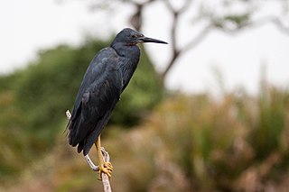
The slaty egret is a small, dark egret. It is one of the species to which the Agreement on the Conservation of African-Eurasian Migratory Waterbirds (AEWA) applies. It is classified as Vulnerable, the biggest threat being habitat loss.

Searsia lucida, previously known as Rhus lucida, and commonly known as the varnished kuni-rhus (English) or blinktaaibos (Afrikaans).

Searsia dentata, the nana-berry (English), or nanabessie (Afrikaans), is a medium sized, deciduous tree, reaching a height of about 5 metres and a spread of 4 metres, and with a tendency to scramble through and over neighbouring trees. It occurs naturally in almost the whole of South Africa except the Western and Northern Cape Provinces. Its habitat varies from sea level to the highlands of the Drakensberg. It is frost-hardy and should be planted in full sun. The strongly aromatic leaves are usually conspicuously toothed, though sometimes they may be only slightly toothed. The tree produces small, creamy-white flowers in masses, developing into small, flattened drupes (5-6mm) which turn red or orange when ripe and brown when dry. The ripe fruits are eaten by birds, while the foliage is food for the larvae of the pepper tree moth Bombycomorpha bifascia.
Vhembe is one of the 5 districts of Limpopo province of South Africa. It is the northernmost district of the country and shares its northern border with Beitbridge district in Matabeleland South, Zimbabwe and on the east with Gaza Province in Mozambique. Vhembe consist of all territories that were part of the former Venda Bantustan, however, two large densely populated districts of the former Tsonga homeland of Gazankulu, in particular, Hlanganani and Malamulele were also incorporated into Vhembe, hence the ethnic diversity of the District. The seat of Vhembe is Thohoyandou, the capital of the former Venda Bantustan. According to 2011 census, the majority of Vhembe residents, about 800,000, speak TshiVenda as their mother language, while 400,000 speak Xitsonga as their home language. However, the Tsonga people are in majority south of Levubu River and they constitute more than 85% of the population in the south of the historic river Levubu, while the Venda are the minority south of Levubu, at 15%. The Northern Sotho speakers number 27,000. The district code is DC34.

The Waterberg is a mountainous massif of approximately 654,033 hectare in north Limpopo Province, South Africa. The average height of the mountain range is 600 m with a few peaks rising up to 2000 m above sea level. Vaalwater town is located just north of the mountain range. The extensive rock formation was shaped by hundreds of millions of years of riverine erosion to yield diverse bluff and butte landform. The ecosystem can be characterised as a dry deciduous forest or Bushveld. Within the Waterberg there are archaeological finds dating to the Stone Age, and nearby are early evolutionary finds related to the origin of humans.

South Africa, officially the Republic of South Africa (RSA), is the southernmost country in Africa. With over 59 million people, it is the world's 23rd-most populous nation and covers an area of 1,221,037 square kilometres. South Africa has three capital cities: executive Pretoria, judicial Bloemfontein and legislative Cape Town. The largest city is Johannesburg. About 80% of South Africans are of Black African ancestry, divided among a variety of ethnic groups speaking different African languages. The remaining population consists of Africa's largest communities of European, Asian, and Multiracial ancestry.

The papermouth, also known as the silverfish is a species of ray-finned fish in the genus Enteromius.

Banhine National Park is a protected area in northern Gaza Province, Mozambique. The park was established on 26 June 1973. In 2013 the limits of Park were updated to better reflect the realities on the ground, particularly the human presence in the area.

The Southeast African cheetah is the nominate cheetah subspecies native to East and Southern Africa. The Southern African cheetah lives mainly in the lowland areas and deserts of the Kalahari, the savannahs of Okavango Delta, and the grasslands of the Transvaal region in South Africa. In Namibia, cheetahs are mostly found in farmlands.
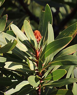
Protea rubropilosa, also known as the Transvaal sugarbush, escarpment sugarbush or Transvaal mountain sugarbush, is a flowering tree, that belongs to the genus Protea in the family Proteaceae. The plant only occurs in South Africa.

