Seavey's Island

Last updated
View of Seavey's Island from Prescott Park in Portsmouth, NH. The large building is the former naval prison. SeaveysIslandApr2016.jpg
View of Seavey's Island from Prescott Park in Portsmouth, NH. The large building is the former naval prison.
Seavey's Island in 1893 1893 U. S. Geological Survey Map of Portsmouth Harbor.jpg
Seavey's Island in 1893

Seavey's Island, on which the Portsmouth Naval Shipyard resides, is located in the Piscataqua River in Kittery, Maine, opposite Portsmouth, New Hampshire. It encompasses 278 acres (1.13 km2).

Portsmouth Naval Shipyard

The Portsmouth Naval Shipyard (PNS), often called the Portsmouth Navy Yard, is a United States Navy shipyard located in Kittery on the southern boundary of Maine near the city of Portsmouth, New Hampshire. PNS is tasked with the overhaul, repair, and modernization of US Navy submarines. The facility is sometimes confused with the Norfolk Naval Shipyard in Portsmouth, Virginia.

Piscataqua River river in Maine and New Hampshire, United States

The Piscataqua River is a 12-mile-long (19 km) tidal river forming the boundary of the U.S. states of New Hampshire and Maine from its origin at the confluence of the Salmon Falls River and Cocheco River. The drainage basin of the river is approximately 1,495 square miles (3,870 km2), including the subwatersheds of the Great Works River and the five rivers flowing into Great Bay: the Bellamy, Oyster, Lamprey, Squamscott, and Winnicut.

Kittery, Maine Town in Maine, United States

Kittery is a town in York County, Maine, United States. Home to the Portsmouth Naval Shipyard on Seavey's Island, Kittery includes Badger's Island, the seaside district of Kittery Point, and part of the Isles of Shoals. The town is a tourist destination known for its many outlet stores.

Contents

History

What is today called Seavey's Island was originally five separate islands conjoined to accommodate the Portsmouth Naval Shipyard. Colonists originally used the rocky islands for collecting wild berries or drying fish on fish flakes. When Secretary of the Navy Benjamin Stoddert decided to create the first federal shipyard in 1800, he authorized the purchase for $5,500 of Fernald's Island (also called Dennett's Island). The largest of the five, Seavey's Island, would be annexed in 1866 and give the grouping its familiar name. Approved by Congress in 1900, a 750-foot (230 m) granite drydock was built in the former gut between Fernald's and Seavey's islands. Clark's, Jamaica and another island were attached to Seavey's.

Berry food

A berry is a small, pulpy, and often edible fruit. Typically, berries are juicy, rounded, brightly colored, sweet or sour, and do not have a stone or pit, although many pips or seeds may be present. Common examples are strawberries, raspberries, blueberries, blackberries, red currants, white currants and blackcurrants. In Britain, soft fruit is a horticultural term for such fruits.

Fish vertebrate animal that lives in water and (typically) has gills

Fish are gill-bearing aquatic craniate animals that lack limbs with digits. They form a sister group to the tunicates, together forming the olfactores. Included in this definition are the living hagfish, lampreys, and cartilaginous and bony fish as well as various extinct related groups. Tetrapods emerged within lobe-finned fishes, so cladistically they are fish as well. However, traditionally fish are rendered paraphyletic by excluding the tetrapods. Because in this manner the term "fish" is defined negatively as a paraphyletic group, it is not considered a formal taxonomic grouping in systematic biology, unless it is used in the cladistic sense, including tetrapods. The traditional term pisces is considered a typological, but not a phylogenetic classification.

Fish flake

A fish flake is a platform built on poles and spread with boughs for drying cod on the foreshore of fishing villages and small coastal towns in Newfoundland and Nordic countries. Spelling variations for fish flake in Newfoundland include flek, fleyke, fleake, flaik and fleack. Its first recorded use in connection with fishing appeared in Richard Whitbourne's book Newfoundland. In Norway, a flake is known as a hjell.

Shipyard dry dock, c. 1908, built in the former gut which separated Fernald's and Seavey's islands Dry Dock, Portsmouth Navy Yard, Kittery, ME.jpg
Shipyard dry dock, c. 1908, built in the former gut which separated Fernald's and Seavey's islands

Atop a hill on the southern end of Seavey's Island stood an earthwork defense called Fort Sullivan, built in 1775 to supplement Fort William and Mary and Fort McClary in the protection of Portsmouth Harbor during the Revolution and, later, War of 1812. After 1815 it was abandoned, then reactivated from 1861 until 1865 during the American Civil War as an 11 gun, 8 inch Rodman naval battery. Another early battery was to the west on Henderson's Point. But on July 22, 1905, the point was blown up in what was then the largest dynamite explosion ever attempted. Because it projected 540 feet (160 m) into the Piscataqua River channel, Henderson's Point created a navigational hazard for warships visiting the navy yard. Consequently, a cofferdam was constructed, behind which 220,000 cubic yards (170,000 m3) of rock and 50,000 cubic yards (38,000 m3) of soil were excavated. Explosives were detonated to remove the rest, with debris flying 170 feet (52 m) in the air. Within seconds, the river was widened by 350 feet (110 m).

Earthworks (engineering) engineering works created through the moving or processing of parts of the earths surface

Earthworks are engineering works created through the processing of parts of the earth's surface involving quantities of soil or unformed rock.

Portsmouth Naval Prison

Portsmouth Naval Prison is a former U.S. Navy and Marine Corps prison on the grounds of the Portsmouth Naval Shipyard (PNS) in Kittery, Maine. The building has the appearance of a castle. The reinforced concrete naval prison was occupied from 1908 until 1974.

Fort William and Mary fort

Fort William and Mary was a colonial fortification in Britain's worldwide system of defenses, manned by soldiers of the Province of New Hampshire who reported directly to the royal governor. The fort, originally known as "The Castle", was situated on the island of New Castle, New Hampshire, at the mouth of the Piscataqua River estuary. It was renamed Fort William and Mary circa 1692, after the accession of the monarchs William III and Mary II to the British throne. It was captured by Patriot forces, recaptured, and later abandoned by the British in the Revolutionary War. The fort was renamed Fort Constitution in 1808 following rebuilding. The fort was further rebuilt and expanded through 1899 and served actively through World War II.

Spanish Navy prisoners of war arriving at Seavey's Island in 1898 Spanish Navy Prisoners of War at Seavey's Island.jpg
Spanish Navy prisoners of war arriving at Seavey's Island in 1898

In 1908, the Portsmouth Naval Prison was completed on the southern side of Seavey's Island at the former site of Camp Long, a stockade named for Secretary of the Navy John Long, where 1,612 prisoners of war from the Battle of Santiago de Cuba were confined from July 11 to mid-September 1898 during the Spanish–American War. Camp Heywood, a Marine camp named after Colonel Charles Heywood, was located just north of the naval prison. It was occupied after the 1st Battalion's return from Cuba in late August until September 21, 1898. According to the National Trust for Historic Preservation, the Portsmouth Naval Shipyard has 62 buildings listed on the National Register of Historic Places.

Stockade enclosure of palisades and tall walls made of logs placed side by side vertically

A stockade is an enclosure of palisades and tall walls made of logs placed side by side vertically with the tops sharpened as a defensive wall.

John Davis Long Massachusetts governor and Congressman; Secretary of the Navy

John Davis Long was an American lawyer, politician, and writer from Massachusetts. He was the 32nd Governor of Massachusetts, serving from 1880 to 1883. He later served as the Secretary of the Navy from 1897 to 1902, a period that included the primarily naval Spanish–American War.

Battle of Santiago de Cuba naval battle near Santiago de Cuba during the Spanish-American war

The Battle of Santiago de Cuba was a naval battle that occurred on July 3, 1898, in which the United States Navy decisively defeated Spanish forces, sealing American victory in the Spanish–American War and achieving nominal independence for Cuba from Spanish rule.

Seavey's Island was the subject of a border dispute between New Hampshire and Maine in 2001, in which New Hampshire asserted that the island lay within the borders of New Hampshire. The State of New Hampshire brought suit against Maine in the Supreme Court, but the Supreme Court held that New Hampshire was estopped from contesting a previous 1977 boundary determination that Maine had jurisdiction over the island, and dismissed the Complaint. [1]

Piscataqua River border dispute

The Piscataqua River border dispute was a dispute between the US states of Maine and New Hampshire over ownership of Seavey’s Island in the Piscataqua River, which forms the border between Maine and New Hampshire. The dispute was settled in 2002 by the US Supreme Court in favor of Maine.

Estoppel judicial device in common law legal systems whereby a court may prevent a person from making assertions or from going back on their word

Estoppel is a judicial device in common law legal systems whereby a court may prevent, or "estop" a person from making assertions or from going back on his or her word; the person being sanctioned is "estopped". Estoppel may prevent someone from bringing a particular claim, particularly if a promise unsupported by consideration is being relied on by the other party. Legal doctrines of estoppel are based in both common law and equity.

Sites of interest

See also

Related Research Articles

Portsmouth, New Hampshire City in New Hampshire, United States

Portsmouth is a city in Rockingham County, New Hampshire, United States. As of the 2010 census it had a population of 21,233, and in 2017 the estimated population was 21,796. A historic seaport and popular summer tourist destination on the Piscataqua River bordering the state of Maine, Portsmouth was formerly the home of the Strategic Air Command's Pease Air Force Base, since converted to Portsmouth International Airport at Pease.

New Castle, New Hampshire Place in New Hampshire, United States

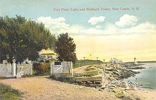
New Castle is a town in Rockingham County, New Hampshire, United States. The population was 968 at the 2010 census. It is the smallest and easternmost town in New Hampshire, and the only one located entirely on islands. It is home to Fort Constitution Historic Site, Fort Stark Historic Site, and the New Castle Common, a 31-acre (13 ha) recreation area on the Atlantic Ocean. New Castle is also home to a United States Coast Guard station, as well as the historic Wentworth by the Sea hotel.

Norfolk Naval Shipyard American airport

The Norfolk Naval Shipyard, often called the Norfolk Navy Yard and abbreviated as NNSY, is a U.S. Navy facility in Portsmouth, Virginia, for building, remodeling, and repairing the Navy's ships. It is the oldest and largest industrial facility that belongs to the U.S. Navy as well as the most multifaceted. Located on the Elizabeth River, the yard is just a short distance upriver from its mouth at Hampton Roads.

USS <i>New Hampshire</i> (SSN-778) Virginia-class submarine

USS New Hampshire (SSN-778), a Virginia-class nuclear-powered attack submarine, is the fourth vessel of the United States Navy to be named for the state of New Hampshire. She is the first of the Virginia Block II submarines to enter service. Her name was awarded to the submarine after a letter-writing campaign by the third-graders from Garrison Elementary School in Dover to their members of Congress, the state governor, and the Secretary of the Navy.

Seacoast Region (New Hampshire)

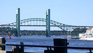
The Seacoast Region is the southeast area of the U.S. state of New Hampshire that includes the eastern portion of Rockingham County and the southern portion of Strafford County. The region stretches 13 miles (21 km) along the Atlantic Ocean from New Hampshire's border with Salisbury, Massachusetts, to the Piscataqua River and New Hampshire's border with Kittery, Maine. The shoreline alternates between rocky and rough headlands and areas with sandy beaches. Some of the beaches are bordered by jetties or groins, particularly in the towns of Rye and Hampton. The Seacoast Region stretches as far west as Epping.

USS <i>Raleigh</i> (1776)

USS Raleigh was one of thirteen ships that the Continental Congress authorized for the Continental Navy in 1775. Following her capture in 1778, she served in the Royal Navy as HBMS Raleigh.

USS <i>Portsmouth</i> (1843)

The second USS Portsmouth was a wooden sloop-of-war in the United States Navy in service during the mid-to-late 19th century. She was designed by Josiah Barker on the lines of a French-built privateer, and built at the Portsmouth Navy Yard, directly across the Piscataqua River from Portsmouth, New Hampshire. She was described as an improvement over the USS Saratoga built in the same shipyard a year earlier. The Portsmouth was launched on 23 October 1843 and commissioned on 10 November 1844, with Commander John Berrien Montgomery in command.

Gundalow ship type

A gundalow is a type of flat-bottom cargo vessel once common in Maine and New Hampshire rivers. They first appeared in the mid-1600s, reached maturity of design in the 1700 and 1800s, and lingered into the early 1900s before vanishing as commercial watercraft. Up to 70 feet (21.34 m) long, they characteristically employed tidal currents for propulsion, with a single huge lateen sail brailed to a heavy yard to harness favorable winds.

Portsmouth Athenæum

The Portsmouth Athenæum is an independent membership library, gallery and museum in Portsmouth, New Hampshire, United States. It preserves material relevant to local history, and sponsors exhibitions, concerts and lectures for its proprietors, scholars and the general public. The building has been listed as the "Portsmouth Athenaeum" on the National Register of Historic Places since 1973.

Badgers Island island in the United States of America

Badger's Island is located in the Piscataqua River at Kittery, Maine, directly opposite Portsmouth, New Hampshire. It carries U.S. Route 1 between the states, connecting to the Kittery mainland by the Badger's Island Bridge, and to New Hampshire by the Memorial Bridge. Now largely a suburb of Portsmouth, the island features houses, condominiums, restaurants and marinas.

William Badger (shipbuilder) American shipbuilder

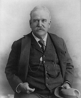
William Badger was a master shipbuilder operating in Kittery, Maine, United States who built more than 100 vessels.

The Harbor Defenses of Portsmouth was a United States Army Coast Artillery Corps harbor defense command. It coordinated the coast defenses of Portsmouth, New Hampshire and the nearby Portsmouth Naval Shipyard in Kittery, Maine from 1900 to 1950, both on the Piscataqua River, beginning with the Endicott program. These included both coast artillery forts and underwater minefields. The command originated circa 1900 as the Portsmouth Artillery District, was renamed Coast Defenses of Portsmouth in 1913, and again renamed Harbor Defenses of Portsmouth in 1925.

Peirce Island is a historic 27-acre (11 ha) island owned by the city of Portsmouth, New Hampshire, and is connected to adjacent outlying Four Tree Island. It is connected to the mainland by the Peirce Island bridge. The islands are open to the public and have views of salt marsh, tidal pools, rocky cliffs, and meadows as well as the Portsmouth Naval Shipyard, the South End, three bridges over the Piscataqua River, the "back channel", and a small island toward New Castle, New Hampshire. There is also an outdoor pool, walking paths, playgrounds, and boat launch area.

References

  1. New Hampshire v. Maine (U.S. 2002) (holding New Hampshire estopped from re-litigating 1977 consent judgment confirming Maine's ownership.)

Coordinates: 43°4′44″N70°44′3″W / 43.07889°N 70.73417°W / 43.07889; -70.73417