
Deatnu (Northern Sami) or Tana (Norwegian) is a municipality in Troms og Finnmark county, Norway. The administrative centre of the municipality is the village of Tana bru. Among the other villages in the municipality are Austertana, Bonakas, Polmak, Rustefjelbma, and Skiippagurra.

Gausdal is a municipality in Innlandet county, Norway. It is part of the traditional region of Gudbrandsdal. The administrative centre of the municipality is the village of Segalstad bru. Follebu is a township and sub-parish in eastern Gausdal.
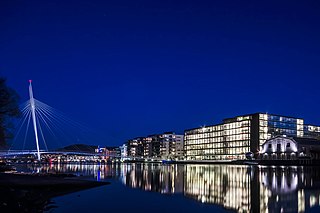
Drammen is a city and municipality in Viken, Norway. The port and river city of Drammen is centrally located in the south-eastern and most populated part of Norway. Drammen municipality also includes smaller towns and villages such as Konnerud, Svelvik, Mjøndalen and Skoger.

Bryne is a town in Time municipality in Rogaland county, Norway. The city is the administrative centre of the municipality of Time and it is also one of the 50 largest towns/cities in Norway. Bryne's location in the region of Stavanger/Sandnes and its road and rail links have made Bryne a popular area for commuters. The city is expanding rapidly and there have been reports of problems with schooling capacity. Bryne Church is located in the centre of the city and Time Church is located 1 kilometre (0.62 mi) east of the city.

Follebu is a village in Gausdal Municipality in Innlandet county, Norway. The village is located along the river Gausa, about 3 kilometres (1.9 mi) to the southeast of the village of Segalstad bru. The town of Lillehammer lies about 15 kilometres (9.3 mi) to the southeast of Follebu.
Tana bru is the administrative centre of Deatnu-Tana Municipality in Troms og Finnmark county, Norway. The village lies on the western bank of the Tana River, along the European route E6 highway.

Sander is a village in the municipality of Sør-Odal in Innlandet county, Norway. The village is located along the river Glomma, about 8 kilometres (5.0 mi) southeast of the village of Skarnes. The village has a train station, a kindergarten, an elementary school and a grocery store. The area around the village is dominated by agriculture. Strøm Church lies about 4 kilometres (2.5 mi) northwest of Sander. The local sports club is Sander IL.

Flisa is the administrative centre of Åsnes Municipality in Innlandet county, Norway. The village lies at the confluence of the rivers Flisa and Glomma. The Norwegian National Road 2 and the Solørbanen railway line both pass through the village. The village of Kjellmyra is located about 3 kilometres (1.9 mi) to the north of this village. Åsnes Church is located on the west side of Flisa.
Nybergsund is a village in the municipality of Trysil in Innlandet county, Norway. It is located about 5 kilometres (3.1 mi) south of the village of Innbygda which is the municipal centre of Trysil. The village is best known for serving as a hiding place for the Norwegian royal family and Cabinet and sustaining German bombing during the German conquest of Norway. The village is also the birthplace of award-winning Norwegian writer and translator Tormod Haugen.

Roverud is a village in Kongsvinger Municipality in Innlandet county, Norway. The village is located about 8 kilometres (5.0 mi) north of the town of Kongsvinger on the east side of the river Glomma. The village has a grocery store, a grade school, offices, elder care facilities, and Roverud Church.
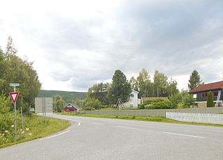
Forset is a village in Gausdal Municipality in Innlandet county, Norway. The village is located along the river Jøra, about 6 kilometres (3.7 mi) west of the villages of Follebu and Segalstad bru. Forset was the administrative centre of the former municipality of Vestre Gausdal, which existed until 1962 when it became a part of Gausdal Municipality. Vestre Gausdal Church is located in the village.

Sel or Nord-Sel is a village in Sel Municipality in Innlandet county, Norway. The village is located in the northern part of the municipality on the south shore of the Gudbrandsdalslågen river, about 12 kilometres (7.5 mi) northwest of the town of Otta. The European route E6 highway runs past the village on the opposite side of the river, and there is a short bridge connecting the village to this highway. The Nord-Sel Church is located in the village, right along the river.

Dokkfløyvatn or Dokkfløyvatnet is a lake which lies in the municipalities of Gausdal and Nordre Land in Innlandet county, Norway. The 9.42-square-kilometre (3.64 sq mi) lake lies along the river Dokka and the Dokkfløy Dam on the river created the lake. The now lake sits at an elevation of 735 metres (2,411 ft) above sea level. The water from the lake is piped through tunnels to the nearby hydroelectric power station. The lake is located about 11 kilometres (6.8 mi) to the southwest of the village of Forset and about 25 kilometres (16 mi) to the west of the town of Lillehammer.

Østre Gausdal is a former municipality in the old Oppland county, Norway. The 227-square-kilometre (88 sq mi) municipality existed from 1879 until its dissolution in 1962. The area is now part of Gausdal Municipality. The administrative centre was the village of Segalstad bru.

Vestre Gausdal is a former municipality in the old Oppland county, Norway. The 959-square-kilometre (370 sq mi) municipality existed from 1879 until its dissolution in 1962. The area is now part of Gausdal Municipality. The administrative centre was the village of Forset.

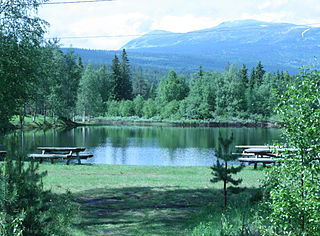
Svingvoll is a village in Gausdal Municipality in Innlandet county, Norway. The village is located along the river Gausa, about 10 kilometres (6.2 mi) southeast of the Skeikampen alpine skiing centre and about 10 kilometres (6.2 mi) to the northwest of the village of Segalstad bru and about 7 kilometres (4.3 mi) to the west of the village of Tretten in the neighboring Øyer Municipality.

Q or Q–meieriene is a private dairy products company based in Bergen, Norway. It is owned by the Kavli Group which in turn is owned by the Kavli Trust (Kavlifondet). It was founded in 2000 and operates two dairies; Jæren Gårdsmeieri located in Jæren and Gausdalmeieriet located in Gausdal. The two dairies process milk from about 500 farms, totaling 170,000 litres of milk daily (2006). Processed products include milk, yogurt, sour cream, cream and juice.

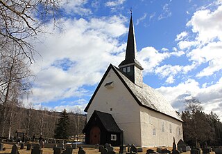
Vestre Gausdal Church is a parish church of the Church of Norway in Gausdal Municipality in Innlandet county, Norway. It is located in the village of Forset. It is the church for the Vestre Gausdal parish which is part of the Sør-Gudbrandsdal prosti (deanery) in the Diocese of Hamar. The white, wooden church was built in a cruciform design in 1784 using plans drawn up by the architect Per Korpberget. The church seats about 400 people.
Østre Gausdal Church is a parish church of the Church of Norway in Gausdal Municipality in Innlandet county, Norway. It is located in the village of Østre Gausdal, about 5 kilometres (3.1 mi) northwest of the village of Segalstad bru. It is the church for the Sel parish which is part of the Sør-Gudbrandsdal prosti (deanery) in the Diocese of Hamar. The white, stone church was built in a long church design around the year 1250 using plans drawn up by an unknown architect. The church seats about 280 people.

Ringebu or Vålebru is the administrative centre of Ringebu Municipality in Innlandet county, Norway. The village is located in the Gudbrandsdal valley, along the Gudbrandsdalslågen river. The European route E6 highway and the Dovrebanen railway line both pass through the village. The 1.85-square-kilometre (460-acre) village has a population (2021) of 1353 and a population density of 733 inhabitants per square kilometre (1,900/sq mi).


