You can help expand this article with text translated from the corresponding article in German. (January 2021)Click [show] for important translation instructions.
|
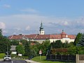
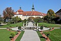
Seitenstetten | |
|---|---|
 Coat of arms | |
 Seitenstetten Location within Austria | |
| Coordinates: 48°1′N14°39′E / 48.017°N 14.650°E | |
| Country | Austria |
| State | Lower Austria |
| District | Amstetten |
| Government | |
| • Mayor | Johann Spreizer |
| Area | |
• Total | 30.46 km2 (11.76 sq mi) |
| Elevation | 349 m (1,145 ft) |
| Population (2018-01-01) [2] | |
• Total | 3,394 |
| • Density | 110/km2 (290/sq mi) |
| Time zone | UTC+1 (CET) |
| • Summer (DST) | UTC+2 (CEST) |
| Postal code | 3353 |
| Area code | 07477 |
| Website | www.seitenstetten-gv.at |
Seitenstetten is a town in the district of Amstetten in Lower Austria in Austria.