
Aleutians East Borough is a 2nd class borough in the U.S. state of Alaska. As of the 2020 census the borough's population was 3,420. The borough seat is Sand Point.

Bethel Census Area is a census area in the U.S. state of Alaska. As of the 2020 census, the population is 18,666, up from 17,013 in 2010. It is part of the unorganized borough and therefore has no borough seat. Its largest community is the city of Bethel, which is also the largest city in the unorganized borough.

Kenai Peninsula Borough is a borough of the U.S. state of Alaska. As of the 2020 census, the population was 58,799, up from 55,400 in 2010. The borough seat is Soldotna, the largest city is Kenai, and the most populated community is the census-designated place of Kalifornsky.
Kodiak Island Borough is a borough in the U.S. state of Alaska. At the 2020 census, the population was 13,101, down from 13,592 in 2010. The borough seat is Kodiak.

Lake and Peninsula Borough is a borough in the state of Alaska. As of the 2020 census, the population was 1,476, down from 1,631 in 2010. The borough seat of King Salmon is located in neighboring Bristol Bay Borough, although is not the seat of that borough. The most populous community in the borough is the census-designated place of Port Alsworth. With an average of 0.017 inhabitants/km2, the Lake and Peninsula Borough is the second least densely populated organized county-equivalent in the United States; only the unorganized Yukon-Koyukuk Census Area has a lower density.
Nome Census Area is a census area located in the U.S. state of Alaska, mostly overlapping with the Seward Peninsula. As of the 2020 census, the population was 10,046, up from 9,492 in 2010. It is part of the unorganized borough and therefore has no borough seat. Its largest community by far is the city of Nome.

Northwest Arctic Borough is a borough located in the U.S. state of Alaska. As of the 2020 census, the population was 7,793, up from 7,523 in 2010. The borough seat is Kotzebue. The borough was formed on June 2, 1986.

Unimak Island is the largest island in the Aleutian Islands chain of the U.S. state of Alaska.

The Kodiak Archipelago is an archipelago south of the main land-mass of the state of Alaska, about 405 km (252 mi) by air south-west of Anchorage in the Gulf of Alaska. The largest island in the archipelago is Kodiak Island, the second-largest island in the United States. The archipelago has a length of about 285 km (177 mi) and a width of about 108 km (67 mi), from the Barren Islands on the north to Chirikof Island and the Semidi Islands group on the south. The archipelago contains 13,890 km2 (5,360 sq mi) of land. The Kodiak Archipelago contains about 40 small glaciers, numerous streams and many species of land and marine animals. Much of its land is forested.

The Alaska Peninsula is a peninsula extending about 800 km (497 mi) to the southwest from the mainland of Alaska and ending in the Aleutian Islands. The peninsula separates the Pacific Ocean from Bristol Bay, an arm of the Bering Sea.

The Kodiak bear, also known as the Kodiak brown bear, sometimes the Alaskan brown bear, inhabits the islands of the Kodiak Archipelago in southwest Alaska. It is the largest recognized subspecies or population of the brown bear, and one of the two largest bears alive today, the other being the polar bear.

The Alaska Maritime National Wildlife Refuge is a United States National Wildlife Refuge comprising 2,400 islands, headlands, rocks, islets, spires and reefs in Alaska, with a total area of 4.9 million acres (20,000 km2), of which 2.64 million acres (10,700 km2) is wilderness. The refuge stretches from Cape Lisburne on the Chukchi Sea to the tip of the Aleutian Islands in the west and Forrester Island in the southern Alaska Panhandle region in the east. The refuge has diverse landforms and terrains, including tundra, rainforest, cliffs, volcanoes, beaches, lakes, and streams.
The Chugach National Forest is a 6,908,540-acre (27,958 km2) United States National Forest in south central Alaska. Covering portions of Prince William Sound, the Kenai Peninsula and the Copper River Delta, it was formed in 1907 from part of a larger forest reserve. The Chugach includes extensive shorelines, glaciers, forests and rivers, much of which is untouched by roads or trails. It hosts numerous bird, mammal and marine species, including extensive shorebird habitat and a bald eagle population larger than the contiguous 48 states combined. Human industry in the forest includes extensive tourism and some mining and oil and gas operations.

The Saint Lazaria Wilderness or St. Lazaria Island is a nesting bird colony located twenty miles (32 km) west of Sitka, Alaska and is a part of the Gulf of Alaska unit of the Alaska Maritime National Wildlife Refuge. It is located in Sitka Sound, just south of Kruzof Island, and within the limits of the City and Borough of Sitka, Alaska. The island's name is Kanasx'ée in the Tlingit language.

Southwest Alaska is a region of the U.S. state of Alaska. The area is not exactly defined by any governmental administrative region(s); nor does it always have a clear geographic boundary.

Sitkinak Island is an island of the Kodiak Archipelago of the state of Alaska, United States. It lies south of the southern tip of Kodiak Island in the western part of the Gulf of Alaska. Tugidak Island lies to its west. The two islands are the largest components of the Trinity Islands of Alaska. The Trinity Islands, and thus Sitkinak, are part of the Gulf of Alaska unit of Alaska Maritime National Wildlife Refuge. Sitkinak Island has a land area of 235.506 km2 and no resident population.
Tugidak Island is an island of the Kodiak Archipelago in Kodiak Island Borough, Alaska, United States. It lies southwest of the southern tip of Kodiak Island in the western part of the Gulf of Alaska. Sitkinak Island lies to its east. The two islands are the largest components of the Trinity Islands of Alaska. The Trinity Islands, and thus Tugidak, are part of the Gulf of Alaska unit of Alaska Maritime National Wildlife Refuge. Tugidak Island has a land area of 173.142 km2 and no resident population. The most prominent feature of the island is the large shallow lagoon near its northeastern end. This part of the island was established as the Tugidak Island Critical Habitat Area by the state of Alaska in 1998 as a wildlife conservation area, and is managed by the Alaska Department of Fish and Game. The island has historically been known as a nesting spot for harbor seals as well as many species of marine birds.
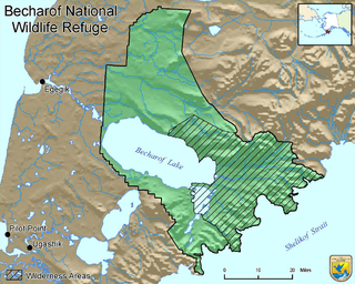
Becharof National Wildlife Refuge is a National Wildlife Refuge in the Aleutian Range of the Alaska Peninsula of southwestern Alaska. It is adjacent to Katmai National Park and Preserve. This national wildlife refuge, which covers an area of 1,200,000 acres (4,900 km2), was established in 1980 to conserve major brown bears, salmon, migratory birds, caribou, marine birds, and mammals and to comply with treaty obligations. It lies primarily in the east-central part of Lake and Peninsula Borough, but extends eastward into the mainland portion of Kodiak Island Borough. The refuge is administered from offices in King Salmon.
Afognak Island State Park is a 75,047-acre (30,370 ha) Alaska state park on Afognak Island in Kodiak Island Borough, Alaska in the United States. Afognak Island is northeast of Kodiak Island on the Alaska Peninsula. Most of Afognak Island State Park is undeveloped. The park is known for its rugged topography and wide variety of wildlife. Afognak Island State Park is open to year-round recreation, including fishing, hunting, and hiking. Transportation is provided by float plane from Kodiak to various areas around the park. It is on the northern and eastern ends of the island and surrounds Perenosa, Seal and Tonki Bays. It borders part of Kodiak National Wildlife Refuge to the west.
The Barren Islands (Sugpiaq: Usu'unaat) are an archipelago in Alaska in the United States. They are the northernmost islands of the Kodiak Archipelago. The largest island of the group is Ushagat Island. The islands have a combined land area of 16.23 square miles (42.03 km²) and are uninhabited. The largest breeding grounds of seabirds in Alaska are located in the Barren Islands on East Amatuli Island and Nord Island. The archipelago is part of the Alaska Maritime National Wildlife Refuge.

