North Korea is located in east Asia on the northern half of the Korean Peninsula.

South Korea is located in East Asia, on the southern half of the Korean Peninsula jutting out from the far east of the Asian landmass. The only country with a land border to South Korea is North Korea, lying to the north with 238 kilometres (148 mi) of border running along the Korean Demilitarized Zone. South Korea is mostly surrounded by water and has 2,413 kilometres (1,499 mi) of coastline along three seas; to the west is the Yellow Sea, to the south is the East China Sea, and to the east is the Sea of Japan. Geographically, South Korea's land mass is approximately 100,032 square kilometres (38,623 sq mi). 290 square kilometres (110 sq mi) of South Korea are occupied by water. The approximate coordinates are 37° North, 127° 30 East.

The Amnok River is a river on the border between North Korea and China. Together with the Duman River to its east, and a small portion of Paektu Mountain, the Amnok forms the border between North Korea and China and is notable as a site involved in military conflicts such as the First Sino-Japanese War, the Russo-Japanese War, World War II, and the Korean War.

Sakhalin is Russia's largest island, lying in the North Pacific Ocean between 45°50' and 54°24' N. It is administered as part of Sakhalin Oblast. Sakhalin, which is about one third the size of Honshu, is just off the east coast of Russia, and just north of Japan. The island's population was 497,973 as of the 2010 census, made up of mostly ethnic Russians and a smaller Korean community. The indigenous peoples of the island are the Ainu, Oroks and Nivkhs.

The Sea of Japan is the marginal sea between the Japanese archipelago, Sakhalin, the Korean Peninsula and Russia. The Japanese archipelago separates the sea from the Pacific Ocean. It is bordered by Japan, Korea and Russia. Like the Mediterranean Sea, it has almost no tides due to its nearly complete enclosure from the Pacific Ocean. This isolation also reflects in the fauna species and in the water salinity, which is lower than in the ocean. The sea has no large islands, bays or capes. Its water balance is mostly determined by the inflow and outflow through the straits connecting it to the neighboring seas and Pacific Ocean. Few rivers discharge into the sea and their total contribution to the water exchange is within 1%.

The Korean Peninsula is located in East Asia. It extends southwards for about 1,100 km (680 mi) from continental Asia into the Pacific Ocean and is surrounded by the Sea of Japan to the east and the Yellow Sea to the west, the Korea Strait connecting the two bodies of water.

Taebaek is a city in Gangwon province, South Korea. Its name is shared with that of the Taebaek Mountains. Situated at an altitude of 650 to 700 m, Taebaek is the highest city in South Korea.
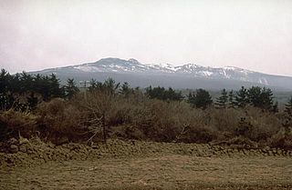
Hallasan is a shield volcano on Jeju Island of South Korea. It is the highest mountain in South Korea. The area around the mountain is a designated national park, the Hallasan National Park. Hallasan is commonly considered to be one of the three main mountains of South Korea, along with Jirisan and Seoraksan.
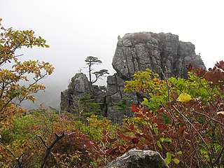
Jirisan is a mountain located in the southern region of South Korea. It is the second-tallest mountain in South Korea after Jeju Island's Hallasan, and the tallest mountain in mainland South Korea. After Jirisan, Seoraksan is the third tallest mountain in South Korea and the second-tallest mountain on the South Korean mainland.

Jeju is the capital of Jeju Province in South Korea and the largest city on Jeju Island. The city is served by Jeju International Airport.

Sacheon is a city in South Gyeongsang Province, South Korea. Sacheon's chief fame comes from its being the site of two naval battles in the Seven Year War.

Tongyeong is a coastal city in South Gyeongsang Province, South Korea. In 2010, it had an area of 238.81 km2 (92.21 sq mi) and a population of 139,869 people. It is divided into 1 eup (town), 6 myeon (township) and 11 dong (neighborhood). Chungmu city and Tongyeong county were reunited in 1995, creating Tongyeong City as it is known today. It consists of Goseong Peninsula, Hansan Island, Mireuk Island and other islets. It was formerly known as Chungmu, after the posthumous name of Admiral Yi Sun-sin. The name Tongyeong means "command post" and is itself associated with Admiral Yi, as it refers to his principal base that was located on nearby Hansan Island.

Tsushima Island is an island of the Japanese archipelago situated in the Korea Strait, approximately halfway between the Japanese mainland and the Korean Peninsula. The main island of Tsushima was once a single island but was divided into two in 1671 by the Ōfunakoshiseto canal and into three in 1900 by the Manzekiseto canal. These canals were driven through isthmuses in the center of the island, creating "North Tsushima Island" (Kamijima) and "South Tsushima Island" (Shimojima). Tsushima also incorporates over 100 smaller islands. The name Tsushima generally refers to all the islands collectively.
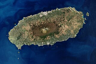
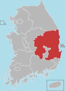
Jeju Island is an island in Jeju Province, South Korea. The island lies in the Korea Strait, south of South Jeolla Province. The island contains the natural World Heritage Site Jeju Volcanic Island and Lava Tubes. Jejudo has a moderate climate; even in winter, the temperature rarely falls below 0 °C (32 °F). Jeju is a popular holiday destination and a sizable portion of the economy relies on tourism and economic activity from its civil/naval base.

Geojedo or Geoje Island is the principal island of Geoje City, on the southern coast of Gyeongsangnam-do province, South Korea. It is joined to land by two bridges from nearby Tongyeong. Gohyeon is the largest town on the island. The Busan-Geoje Fixed Link was open in December 2010 and provides a more direct connection to the city of Busan.

Korea is located on the Korean Peninsula in North-East Asia. To the northwest, the Amnok River separates Korea from China and to the northeast, the Duman River separates Korea from China and Russia. The Yellow Sea is to the west, the East China Sea and Korea Strait is to the south, and the Sea of Japan is to the east. Notable islands include Jeju Island (Jejudo), Ulleung Island (Ulleungdo), and Liancourt Rocks.

The 2008 EAFF East Asian Football Championship was held between 17 February and 23 February 2008. The preliminary competitions were held from 25 March to 24 June 2007.
The Taego Order or Taego-jong is the second largest order in Korean Seon, the Korean branch of Chan Buddhism.

Uliaga Island is the northernmost member of the Islands of the Four Mountains group in the Aleutian Islands of southwestern Alaska. The island's name is probably derived from the Aleut place name ulaĝa, which is itself derived from ulaẍ - "bearberry." The triangular shaped island measures about 2.4 miles (3.9 km) across and consists of a single stratovolcano cone that reaches a height of 2,913 feet (888 m). The island has an area of 3.44 square miles (8.9 km2). No eruptions have been recorded in historical times, though it is thought to have been active at some time during the Holocene Epoch.

Mahaffey Glacier is a glacier flowing into the head of Morgan Inlet at the east end of Thurston Island, Antarctica. It was named by the Advisory Committee on Antarctic Names after J.S. Mahaffey, a Photographer's Mate in the Eastern Group of U.S. Navy Operation Highjump, which obtained aerial photographs of Thurston Island and adjacent coastal areas in 1946–47.