Related Research Articles

Northumberland County is an upper-tier level of municipal government situated on the north shore of Lake Ontario, east of Toronto in Central Ontario. The Northumberland County headquarters are located in Cobourg.

Hastings County is located in the province of Ontario, Canada. Geographically, it is located on the border of Eastern Ontario and Central Ontario. Hastings County is the second largest county in Ontario. The county seat is Belleville, which is independent of Hastings County. Hastings County has trademarked the moniker "Cheese Capital of Canada".
Tweed is a municipality located in central-eastern Ontario, Canada, in Hastings County.
Marmora and Lake is a municipality along the banks of Crowe River and Beaver Creek, about midway between Toronto and Ottawa on provincial Highway 7 in Hastings County in Central Ontario, Canada. It is home to approximately 4,000 full time and seasonal residents, many of whom enjoy outdoor recreation and relaxation on Crowe Lake.
Asphodel–Norwood is a lower tier township municipality in Peterborough County in Central Ontario, Canada, with a 2016 population of 4,109. The land on which the township is situated was the traditional territory of the Mississauga, and became open to European colonization following its survey in 1820. The site that would become Norwood was settled in 1823, and it was incorporated as a village in 1878. The township, in its current form, was created in 1998 by the reunification of the village of Norwood with the surrounding township of Asphodel.
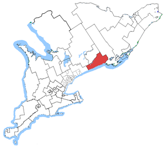
Northumberland—Quinte West was a federal electoral district in Ontario, Canada, that was represented in the House of Commons of Canada from 2004 to 2013. Its population in 2001 was 118,906. Following the Canadian federal electoral redistribution, 2012, the electoral district was dissolved into the ridings of Northumberland—Peterborough South and Bay of Quinte.

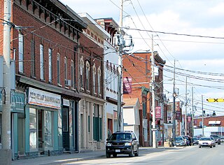
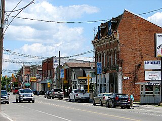
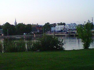
Campbellford is an unincorporated place and former town in Northumberland County, Ontario, Canada, in the township municipality of Trent Hills. It lies approximately midway between Toronto and Ottawa. It is situated on both the Trent-Severn Waterway and the Trans Canada Trail. It can be reached from Highway 401 by exiting at Brighton and going north on County Road 30. It can also be reached from Highway 7 at the Havelock exit going south. Campbellford is surrounded by prime agricultural land which is home to many farms. In recent years, some of the town's agricultural sector has diversified into non-traditional areas such as bison farming, rare breeds farming and there are many horse farms in the area. The town has a farmers market that is open two days a week in the summer.
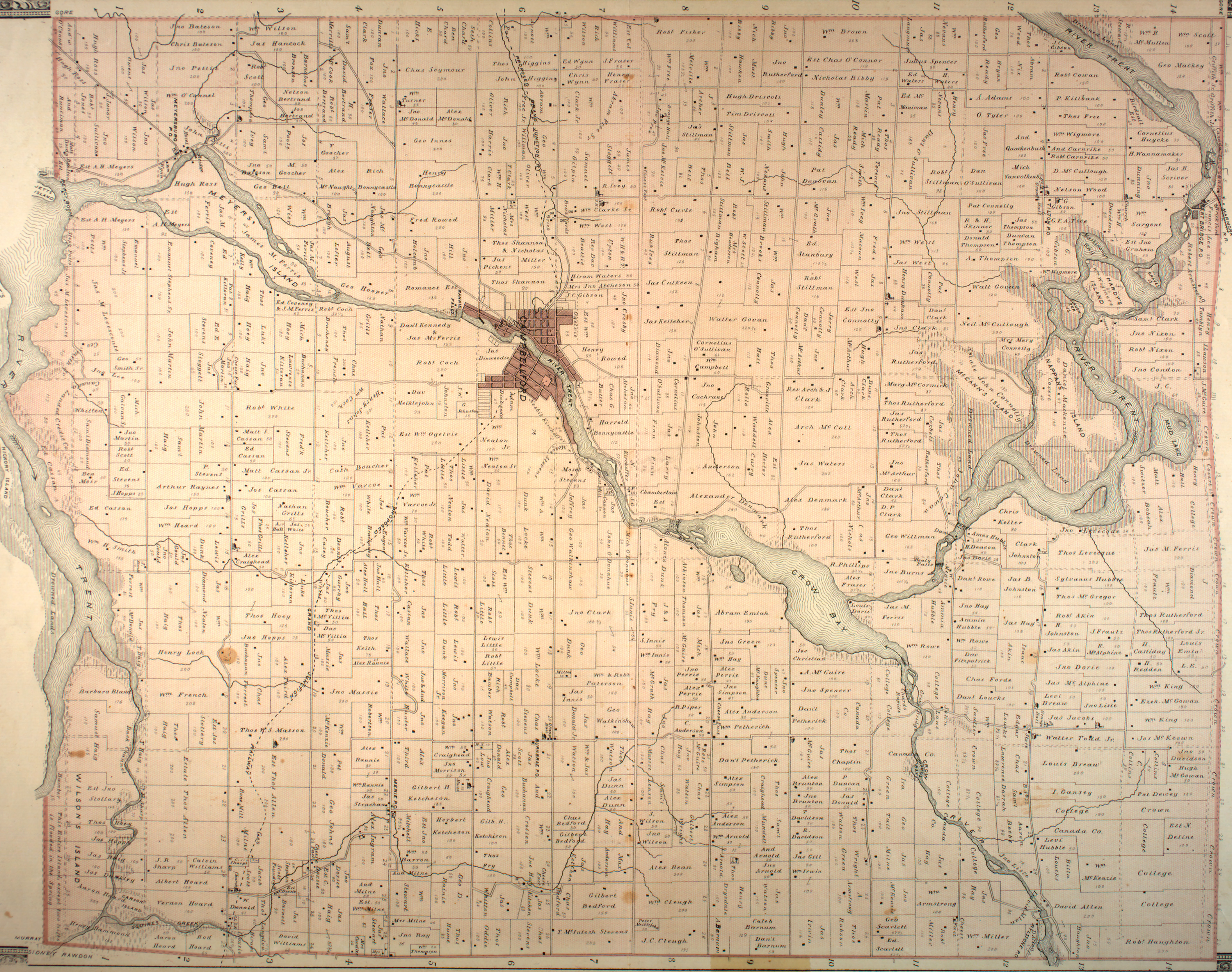
The Municipality of Trent Hills is a township municipality in Northumberland County in Central Ontario, Canada. It is on the Trent River and was created in 2001 through the amalgamation of the municipalities of Campbellford/Seymour, Percy Township and Hastings. Thereafter it was known in brief as Campbellford/Seymour, Percy, Hastings.

The Crowe River is a river in the counties of Haliburton, Hastings, Northumberland and Peterborough in southern Ontario, Canada. It is in the Lake Ontario drainage basin and is a tributary of the Trent River.

Warkworth is a community in the municipality of Trent Hills, Northumberland in Central Ontario, Canada. Originally known as Percy Mills, the village of Warkworth was incorporated in 1857, and became part of Trent Hills when the latter was formed in 2001. Warkworth is named after Warkworth, Northumberland.
Northumberland East was a federal electoral district represented in the House of Commons of Canada from 1867 to 1917. It was located in the province of Ontario. It was created by the British North America Act of 1867.

Cramahe is a rural township located in Northumberland County in central Ontario, Canada. It is situated just off Ontario Highway 401 approximately 140 km East of Toronto. It was named for Hector Theophilus de Cramahé, who was Lieutenant-Governor of the Province of Quebec. The seat of the Township and largest town is Colborne.
Sophiasburgh is an historic township in southern Ontario, Canada, one of the three original townships that formed Prince Edward County. The other two townships were Ameliasburgh and Marysburgh. It was named in 1798 after Princess Sophia, the fifth daughter of George III. The township was amalgamated into the Corporation of the County of Prince Edward, a single tier municipality, on January 1, 1998.
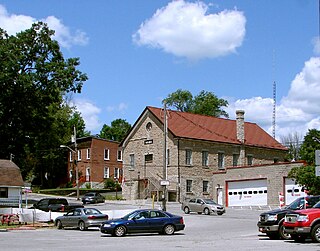
Hastings is a community within the municipality of Trent Hills, Northumberland County, in the province of Ontario, Canada. It is situated on the Trent-Severn Waterway and the Trans Canada Trail in what is considered to be Ontario's "cottage country". It can be reached from Highway 401 by exiting at exit 474 at Cobourg and going north on County Road 45. It can be reached from Highway 7 at the Norwood exit going south.
Percy, Ontario was a former incorporated township and now a geographic township located in Northumberland County, Ontario, Canada. It is currently part of the Municipality of Trent Hills.

Wollaston is an incorporated township in Hastings County, Ontario, Canada. The township had a population of 670 in the Canada 2016 Census.
King's Highway 30, commonly referred to as Highway 30, was a provincially maintained highway in the Canadian province of Ontario. The 51.1-kilometre (31.8 mi)-long route connected Highway 2 in Brighton with Highway 7 in Havelock via Campbellford. Established in 1930, the highway initially travelled only as far north as Campbellford. Alongside the construction of Highway 7 between Peterborough and Perth, Highway 30 was extended north to Havelock in 1934. The route remained generally consistent until 1998, when it was decommissioned and transferred to Northumberland County and Peterborough County. Both counties redesignated their portion of the former highway as County Road 30.
King's Highway 45, commonly referred to as Highway 45, was a provincially maintained highway in the Canadian province of Ontario. The 54.1-kilometre-long (33.6 mi) route connected Highway 2 in downtown Cobourg with Highway 7 in Norwood. In addition to the towns at either end, it bisected the communities of Baltimore, Fenella, Alderville, Roseneath and Hastings.

Percy Creek is a stream in the municipalities of Trent Hills and Alnwick/Haldimand, Northumberland County, in Central Ontario, Canada. It is in the Great Lakes Basin and is a right tributary of the Trent River. Percy Creek is named after Elizabeth Percy, Duchess of Northumberland.
Burnley Creek is a stream in the municipalities of Trent Hills and Alnwick/Haldimand, Northumberland County, in Central Ontario, Canada. It is in the Great Lakes Basin and is a right tributary of Percy Creek.
References
- ↑ "Seymour". Geographical Names Data Base. Natural Resources Canada . Retrieved 2014-05-10.
- ↑ "Township of Seymour" (JPG). Canadian County Atlas Project. McGill University. 2001. Retrieved 2014-05-10.
- 1 2 Restructured municipalities - Ontario map #5 (Map). Restructuring Maps of Ontario. Ontario Ministry of Municipal Affairs and Housing. 2006. Retrieved 2014-05-10.