
Crete is the largest and most populous of the Greek islands, the 88th largest island in the world and the fifth largest island in the Mediterranean Sea, after Sicily, Sardinia, Cyprus, and Corsica. Crete rests about 160 km (99 mi) south of the Greek mainland, and about 100 km (62 mi) southwest of Anatolia. Crete has an area of 8,450 km2 (3,260 sq mi) and a coastline of 1,046 km (650 mi). It bounds the southern border of the Aegean Sea, with the Sea of Crete to the north and the Libyan Sea to the south. Crete covers 260 km from west to east but is narrow from north to south, spanning three longitudes but only half a latitude.
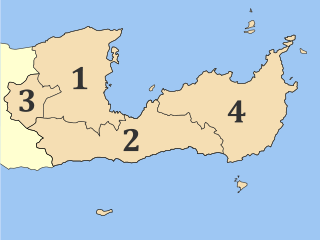
Lasithi is the easternmost regional unit on the island of Crete, to the east of Heraklion. Its capital is Agios Nikolaos, the other major towns being Ierapetra and Sitia. The mountains include the Dikti in the west and the Thrypti in the east. The Sea of Crete lies to the north and the Libyan Sea to the south.

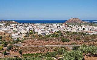
Sitia or Siteia is a port town and a municipality in Lasithi, Crete, Greece. The town has 11,166 inhabitants and the municipality has 20,438 (2021). It lies east of Agios Nikolaos and northeast of Ierapetra. Sitia's port is on the Sea of Crete, part of the Aegean Sea and is one of the economic centers of the Lasithi region. European route E75, which ends in Vardø, starts in Sitia. Sitia is served by the Sitia Public Airport. Sitia has not experienced the effects of mass tourism even though there is a long beach along the road leading to Vai and several places of historical interest.

Agios Nikolaos, Hagios Nikolaos or Aghios Nikolaos is a coastal city on the Greek island of Crete, lying east of the island's capital Heraklion, north of the city of Ierapetra and west of the city of Sitia.
Palaikastro or Palekastro, with the Godart and Olivier abbreviation PK, is a thriving town, geographic heir to a long line of settlements extending back into prehistoric times, at the east end of the Mediterranean island Crete. The Kallikratis Programme implemented starting 2011 made the town into a local community under jurisdiction of the next-highest levels, chained as follows: municipal unit Itanos, municipality (demos) Sitia, regional unit Lasithi, region (periphereia) Crete.
Itanos is a municipal unit of the municipality (demos) Siteia in the Lasithi regional unit, eastern Crete, Greece. A former municipality itself, it was included in Siteia as part of the 2011 local government reform. The municipal unit has an area of 197.406 km2 (76.219 sq mi). The population was 2,014 in 2021.

Lefki is a former municipality in the Lasithi regional unit, eastern Crete, Greece. Since the 2011 local government reform it is part of the municipality Sitia, of which it is a municipal unit. The municipal unit has an area of 152.303 km2 (58.805 sq mi). Population 1,466 (2021). The seat of the municipality was in Ziros.

Makry Gialos is a former municipality in Lasithi, Crete, Greece, with a population 2,589 in 2021. It is located on the south-east coast of Crete. Since the 2011 local government reform it is part of the municipality Ierapetra, of which it is a municipal unit. The municipal unit has an area of 75.376 km2 (29.103 sq mi). The seat of the municipality was in Koutsouras, 22 kilometers east of Ierapetra. It was established in 1997 when the communities of Stavrochori, Chrysopigi, Lithines, Schinokapsala, Agios Stefanos, Oreino, Perivolakia and Pefkoi amalgamated into one municipality (Δήμος). In November 2011 the four communities Chrysopigi, Lithines, Perivolakia and Pefkoi passed to the municipality Siteia.

Ziros is a village in the municipality Sitia, Lasithi regional unit, Crete, Greece. It was the seat of government for the former municipality Lefki.

Karydi, officially Καρύδιον (Σητείας), is a village in the highlands of east Crete, Greece, part of the municipal unit Itanos. Under the Kallikratis Programme of 2011 it was made a local community. Its chain of civic jurisdiction is as follows: municipal unit Itanos, municipality (demos) Sitia, regional unit Lasithi, region (periphereia) Crete.
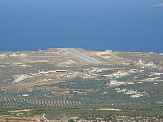
Sitia Airport is a small community airport in the region Mponta of Sitia Municipality, on the eastern part of Crete in Greece. The facility is serving the city of Sitia. The airport is located 1 km north/northwest of the city center.

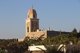
Toplou Monastery is a currently active monastery located in a semi-arid area of the Lasithi regional unit, on the eastern part of the island of Crete in Greece. It is about 6 km (3.7 mi) north of Palekastro and 85 km (53 mi) east of Agios Nikolaos. It is at the base of the Itanos promontory from which Cape Sidero, the easternmost point of Crete, projects to the northeast. The nearest settlements are Sitia to the west and Palaikastro to the southeast; otherwise, the entire promontory is uninhabited except for the modern military reservation at the tip of the cape. In the political structure of Greece, the monastery has been assigned the settlement (oikismos) of Toplou, which it had before 2011, but was validated again in the redivision of 2011. The full civic classification beyond Toplou from 2011 in ascending order is: local community Palaikastro, municipal unit Itanos, municipality (demos) Siteia, regional unit Lasithi, region (periphereia) Crete.

Greek National Road 90, also known as VOAK is the longest National Highway on the island of Crete, Greece. It runs along the north coast of the island Crete. It connects Kissamos in the west with Siteia in the east, via Chania, Rethymno, Heraklion and Agios Nikolaos.

The Dionysades is a small, northward-trending archipelago off the north coast of the island of Crete, mid-way between the Cape Sidero lighthouse to the southeast ; and Sitia to the southwest. Although the island group is uninhabited, it administratively falls within the Sitia municipal unit of the Lasithi Region, Crete Regional Administration. The group includes the islands of Dragonada, Gianysada, Paximadaki, and Paximada.

Kyriamadi or Kereamathi has a double sense. Geographically it is the middle peninsula of Cape Sideros in the municipality of Sitia, in the northeast of Crete. Small landbridges connect it on the one hand to the Itanos promontory of mainland Crete to the southwest, and on the other hand the outermost peninsula Sideros to the northeast. In the Sea of Crete just offshore to the west are two small insular structures, the Kyriamadi "islands", which must take their name from the peninsula.
Stavrochori is an historic village of eastern Crete. It belonged to the former province of Sitia and later to the former Makry Gialos municipality. Today it is part of Ierapetra municipality. It is located in a wooded valley, 29 kilometers north east from Ierapetra and 35 kilometers southwest from Sitia. Once it was the most populous village of the region and the administrative center of the surrounding settlements. Since the last 30 years, the majority of its population has moved to the seaside settlement of Koutsouras, 7 kilometers to the south. Stavrochori is a traditional village with many sights. It is also the birthplace of Ioannis Papachatzakis or "Stravogiannios", a violinist, who lived and died in Ierapetra. He was one of the most important Cretan traditional organ players of the last century.
Agios Stefanos is a village within the Lasithi prefecture in eastern Crete. It belonged to the former province of Siteia until that was abolished in 2006. Between 1997 and 2010, it was part of the former Makry Gialos municipality. Today, it is part of Ierapetra municipality. It is located 30 kilometers north-east of Ierapetra, 40 kilometers southwest of Sitia, and six kilometers east of Stavrohori. It can be approached through the famous forest of Pefkoseli. Its patron is Saint Stephen. Saint Stephen church, at the entrance of the village, is an ecclesiastical and historical monument of Crete. Since the last decade, the majority of the population has been moved to the village's seaside settlement of Makry Gialos, some six kilometers to the south. Makry Gialos is one of Crete's most important tourist resorts.
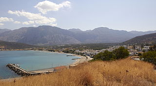
Pacheia Ammos is a village in the municipality of Ierapetra on the island of Crete in Greece. It is located on the north coast of the island, 15 km to the north of the city of Ierapetra, at the fork in the road that leads to Heraklion in the west and Sitia in the east.
Cape Sideros or Cape Sidero is a cape at the eastern end of the island of Crete, Greece. Anciently it was known as Samonium or Samonion, Sammonium or Sammonion, Salmonium or Salmonion (Σαλμώνιον) and Salmone (Σαλμώνη). The cape shares the name Sideros or Sidero with the island-like peninsula of which it is a projection, but which had the name first remains unknown, as does the provenance of either name. Cape Sidero is often not confined to the peninsula Sideros, but might refer to the entire northeast promontory.
The 2021 Lasithi earthquake was a magnitude 6.4 earthquake with a maximum intensity of VIII (Severe) on the Modified Mercalli Intensity Scale which occurred on 12 October 2021, 12:24 (UTC+3:30) off the island of Crete. The quake was also felt at low intensity as far as Cairo and Istanbul.

