
Glen Affric is a glen south-west of the village of Cannich in the Highland region of Scotland, some 15 miles west of Loch Ness. The River Affric runs along its length, passing through Loch Affric and Loch Beinn a' Mheadhoin. A minor public road reaches as far as the end of Loch Beinn a' Mheadhoin, but beyond that point only rough tracks and footpaths continue along the glen.

Cannich is a village at the southern end of Strathglass, in the Highlands of Scotland, about 26 miles (42 km) west of the city of Inverness. It is at the furthest point of the A831 that loops around the Aird from Beauly to Drumnadrochit.
A number of hills in Scotland are named An Socach:

Sgurr na Lapaich is a mountain in the Northwest Highlands of Scotland, situated north of Loch Mullardoch in the high ground that separates Glen Cannich and Glen Strathfarrar. The mountain reaches a height of 1,150 metres, and is the fourth highest mountain north of the Great Glen. There is no higher ground to the north of it in Great Britain.
Glen Strathfarrar is a glen in the Highland region of Scotland, near Loch Ness.
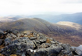
Càrn nan Gobhar is a Scottish mountain situated on the northern side of Loch Mullardoch in the upper part of Glen Cannich. It stands some 50 kilometres west-southwest of the city of Inverness in a remote group of four Munros informally known as “The Mullardochs” which form the high ground between Loch Mullardoch and Loch Monar.
Carn nan Gobhar may refer to:
The Affric / Beauly hydro-electric power scheme for the generation of hydro-electric power is located in the western Highlands of Scotland. It is based around Glen Strathfarrar, Glen Cannich and Glen Affric, and Strathglass further downstream.

Glen Cannich is a long glen in the Northwest Highlands of Scotland and through which runs the River Cannich. Emerging from the reservoir of Loch Mullardoch, the river flows east to merge with the River Affric at the village of Cannich, their combined waters forming the River Glass.
Beinn Fhionnlaidh is the name of two mountains in Scotland, both listed as Munros:

Beinn Fhionnlaidh is a mountain in the Highlands of Scotland. It is situated on the south side of Loch Mullardoch, at the end of Glen Cannich, about 60 km west of Inverness.

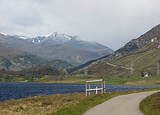
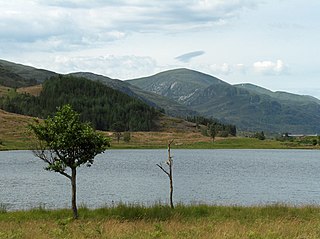
Loch Mullardoch is a major reservoir in Glen Cannich in the Northwest Highlands of Scotland. It was created by the damming in 1951 of the River Cannich just upstream of Mullardoch House, as part of the Affric-Beauly hydro-electric power scheme. A car park at the southern end of the dam is the terminus of the public road up Glen Cannich. The reservoir extends for about 14 km westwards up the glen to the point where the Abhainn a Choilich and Abhainn Sithidh burns drop down from the West Benula deer forest.
Glen Urquhart High School is a six-year comprehensive secondary school situated in Drumnadrochit. The school's primary catchment area ranges from Abriachan in the north to Invermoriston in the south, and as far west as Cannich and Tomich. Its associated Primary schools are Glenurquhart, Balnain and Cannich Bridge.

An Socach is a mountain at the head of Glen Cannich, in the Highlands of Scotland. It is situated between Loch Mullardoch in Glen Cannich, and Loch Monar in Glen Strathfarrar.
Toll Creagach is a mountain in the Northwest Highlands of Scotland. It lies between Glen Affric in the south and Loch Mullardoch in Inverness-shire.

Aonach Shasuinn is a mountain in the Northwest Highlands of Scotland. It lies in Inverness-shire, on the southern side of Glen Affric.
Strathglass is a strath or wide and shallow valley in the Northwest Highlands of Scotland down which runs the meandering River Glass from the point at which it starts at the confluence of the River Affric and Abhainn Deabhag to the point where, on joining with the River Farrar at Struy, the combined waters become the River Beauly.

Tom a' Chòinich is a 1,112-metre (3,648 ft) mountain in Glen Affric in the Scottish Highlands. It is a Munro and less than 1 kilometre to the west is the 1,032-metre (3,386 ft) Munro Top Tom a' Chòinich Beag. In Gaelic, Tom a' Chòinich means "mossy hillock". Its prominence is 149 metres (489 ft) with its parent peak, Càrn Eige, about 4 kilometres (2.5 mi) to the west. This mountain should not be confused with the 955-metre (3,133 ft) Munro Top also called Tom a' Chòinnich near Ben Wyvis but which is usually spelled slightly differently.

