Shah Hassan Khel

Last updated
Shah Hassan Khel
Village
Pakistan location map.svg
Red pog.svg
Shah Hassan Khel
Location in Pakistan
Coordinates: 32°25′54″N70°57′56″E / 32.43167°N 70.96556°E / 32.43167; 70.96556 Coordinates: 32°25′54″N70°57′56″E / 32.43167°N 70.96556°E / 32.43167; 70.96556
Country Flag of Pakistan.svg  Pakistan
Region Khyber Pakhtunkhwa
District Lakki Marwat District
Population (2011)
  Total 4,000 (approx.)
Time zone PST (UTC+5)

Shah Hassan Khel is a village to the south of Lakki Marwat, in the Lakki Marwat District, on the Lakki Marwat Road between Lakki Marwat and Shahbaz Khel, Punjab. In 2011, it had some 4,000 inhabitants in about 500 households. [1] The village is located between two streams which lead down from a southern tributary of the Tochi River. [2] [3] The area to the south is mountainous, known as the Sheikh Budin Range. [2] [3] A troubled area with the Taliban since around 2007, in 2010 a terrorist attack took place here killing at least 97 people and wounding some 40 others.

Lakki Marwat District Headquarter / City in Khyber Pakhtunkhwa, Pakistan

Lakki Marwat or Lakki is the headquarters of Lakki Marwat District in Khyber-Pakhtunkhwa province of Pakistan.

Lakki Marwat District District in Khyber Pakhtunkhwa, Pakistan

Lakki Marwat is one of the southern districts of Khyber Pakhtunkhwa Province in Pakistan. It was created as an administrative district on July 1, 1992, prior to which it was a tehsil of Bannu District.

Contents

History

Historically, Shah Hassan Khel was a village unit of the tehsil of Marwat. [3] Administratively it bordered the village units of Ahmed Khel to the north, Abdul Khel to the southwest, and the southwestern part of Chowki Jand to the south and southeast. [3] In 1992, Marwat tehsil became a part of Lakki Marwat District. The neighbouring villages of Ahmed Khel and Abdul Khel constitute official union councils of the district today.

The Marwat is a Pashtun tribe, a branch of the Lohani tribe and belong to Lodi section of the Mati Afghans, located primarily in Lakki Marwat District, parts of Dera Ismail Khan District, some villages of Tank district and in the Katawaz area of Afghanistan. The Marwats are also known as Spin Lohani, and their most closely related kin are other Lohani tribes like Miya Khel, Daulat Khel and Tatur. In the Afghan dynasty of Hind (1451-1526), Lohanis were the most powerful among the Lodi Afghans and were in possession of one quarter of jagirs in India. The Marwats were named for their ancestor Marwat Khan Lodi.

Ahmed Khel is a town and union council in Lakki Marwat District of Khyber-Pakhtunkhwa, Pakistan.

Abdul Khel is a town and union council in the Lakki Marwat District of Khyber Pakhtunkhwa, Pakistan. It is located at 32°23'59N 70°54'49E and has an altitude of 493 metres.

The first mentions of trouble with the Taliban in the region of Shah Hassan Khel date from early 2007, with extremists taking six hostages at a marriage party and beating up a group of singers. [4] After the 2007 Siege of Lal Masjid, Taliban militants took first control of the Shah Hassan Khel mosque, and soon of the whole village. When Pakistan security forces tried to expunge the militants from the village in the summer of 2009, the village became a ghost town for three months, with all villagers fleeing to other villages close by. After the operation was successfully ended and 24 militants were captured by the Pakistani forces, the villagers returned and organised a lashkar, a village militia to defend themselves and prevent the return of the Taliban. This worked, despite a volunteer of the militia being killed in a skirmish. [1]

The Siege of Lal Masjid was a confrontation in July 2007 between Islamic fundamentalist militants and the Government of Pakistan, led by President Pervez Musharraf and Prime Minister Shaukat Aziz. The focal points of the operation were the Lal Masjid and the Jamia Hafsa madrasah complex in Islamabad, Pakistan.

2010 terrorist attack

On 1 January 2010 a Mitsubishi Pajero suicide bomb car with some 600 pounds of explosives drove into a village square where a crowd was watching a volleyball game played by some members of the lashkar, while most of the elders of the village and the lashkar were meeting in a nearby mosque. The blast caused at least 97 deaths (other sources claim 105 deaths), with a further 40 wounded. An unknown organisation within the Tehrik-i-Taliban Pakistan (TTP) was responsible for the attack, which caused the most fatalities of any TTP attack. [5] [6] The driver of the bomb car was the son of a member of the Shah Hassan Khel lakshar. [1]

Tehrik-i-Taliban Pakistan terrorist group based along the Afghan border in Pakistan

Tehrik-i-Taliban Pakistan, alternatively referred to as the Taliban, is an Islamic armed group which is an umbrella organization of various militant groups based in the Khyber Pakhtunkhwa province along the Afghan border in Pakistan. Most Taliban groups in Pakistan coalesce under the TTP. In December 2007 about 13 groups united under the leadership of Baitullah Mehsud to form the Tehrik-i-Taliban. Among the Tehrik-i-Taliban stated objectives are resistance against the Pakistani state, Pakistani army, enforcement of their interpretation of sharia and a plan to unite against NATO-led forces in Afghanistan.

In response to the attack, the villages expanded the armed militia to defend the town and to hunt down those responsible for the attack. A boys' school which had also been demolished during the attack was rebuilt and reopened in 2012. [7]

Geography

Shah Hassan Khel is located in northern central Pakistan in Lakki Marwat District of Khyber Pakhtunkhwa. By road it is located 20.4 kilometres (12.7 mi) south of the district town of Lakki Marwat, 84.5 kilometres (52.5 mi) southeast of Bannu, and 167 kilometres (104 mi) south of Kohat. [2] The main road connecting the village, Lakki Marwat Road, stems from the Indus Highway, the N55 road. Like the N55, this road connects Shahbaz Khel in the southwest and Sarai Naurung to the northwest, but bypasses the route, passing through Shah Hassan Khel and the district town of Lakki Marwat en route. [2]

Khyber Pakhtunkhwa Province in Pakistan

Khyber Pakhtunkhwa is one of the four administrative provinces of Pakistan, located in the northwestern region of the country along the international border with Afghanistan. It was previously known as the North-West Frontier Province (NWFP) until 2010 when the name was changed to Khyber Pakhtunkhwa by the 18th Amendment to Pakistan's Constitution, and is known colloquially by various other names. Khyber Pakhtunkhwa is the third-largest province of Pakistan by the size of both population and economy, though it is geographically the smallest of four. Within Pakistan, Khyber Pakhtunkhwa shares a border with Punjab, Balochistan, Azad Kashmir, Gilgit-Baltistan, and Islamabad. It comprises 10.5% of Pakistan's economy, and is home to 17.9% of Pakistan's total population, with the majority of the province's inhabitants being Pashtuns. The province is the site of the ancient kingdom Gandhara, including the ruins of its capital Pushkalavati near modern-day Charsadda. Originally a stronghold of Buddhism, the history of the region was characterized by frequent invasions under various Empires due to its geographical proximity to the Khyber Pass.

Bannu City in Khyber Pakhtunkhwa, Pakistan

Banū or Bannu is a city located in Bannu District in southern Khyber Pakhtunkhwa, Pakistan. Founded by Sir Herbert Benjamin Edwardes in 1848 during the British colonial era, Bannu was once a British military base used for action against the Pashtun border tribes of the Tochi Valley and Waziristan. Bannu’s residents are primarily members of the Banuchi tribe and speak a dialect of Pashto that is similar to the distinct Wazir dialect.

Kohat City in Khyber Pakhtunkhwa, Pakistan

Kohat, is a city in the Khyber Pakhtunkhwa province of Pakistan which serves as the capital of the Kohat District. The city is regarded as a centre of the Bangash tribe of Pashtuns, who have lived in the region since the late 15th century. Kohat's immediate environs were the site of frequent armed skirmishes between British colonialist forces and local tribesmen in the mid to late 19th century. Modern Kohat is now a medium-sized city with a population of approximately 270,000 people, and centres on a British-era fort, various bazaars, and a military cantonment.

The village is located between two streams which lead down from a southern tributary of the Tochi River. [2] [3] The Indus River flows some way to the east of the village. The area to the south is mountainous, known as the Sheikh Budin Range. [2] [3]

Related Research Articles

Waziristan area

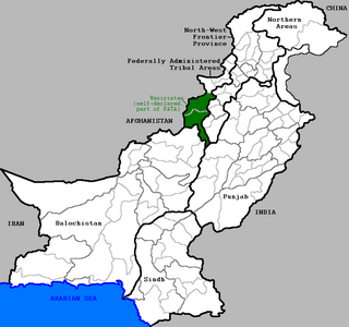
Waziristan is a mountainous region covering the former FATA agencies of North Waziristan and South Waziristan and now districts of Khyber Pakhtunkhwa province of Pakistan. Waziristan covers some 11,585 square kilometres (4,500 sq mi). The area is mostly populated by ethnic Pashtuns. It is named after the Wazir tribe. The language spoken in the valley is Pashto, predominantly the Waziristani dialect. The region forms the southern part of Pakistan's Federally Administered Tribal Areas, which is now part of Khyber Pakhtunkhwa province.

Bannu District District in Khyber Pakhtunkhwa, Pakistan

Bannu District is a district of the Khyber Pakhtunkhwa province of Pakistan. It was recorded as a district in 1861 during the British Raj. It is one of 26 districts that make up the Khyber Pakhtunkhwa province of Pakistan. It borders North Waziristan to the northwest, Karak to the northeast, Lakki Marwat to the southeast, and South Waziristan to the southwest. It is represented in the provincial assembly by four MPAs. The district's main city is Bannu.

North Waziristan District in Khyber Pakhtunkhwa, Pakistan

North Waziristan is a former agency of defunct Federally Administered Tribal Area and district of Khyber Pakhtunkhwa province of Pakistan. It is the northern part of Waziristan, a mountainous region of northwest Pakistan, bordering Afghanistan and covering 4,707 square kilometres (1,817 sq mi).

Khyber District District in Khyber Pakhtunkhwa, Pakistan

Khyber is a district of Khyber Pakhtunkhwa, Pakistan. Until 2018, it was an agency of Federally Administered Tribal Areas, with merger of FATA with Khyber Pakhtunkhwa, it became a district. It ranges from the Tirah valley down to Peshawar. It borders Nangarhar Province to the west, Orakzai District to the south, Kurram District to south west, Peshawar to the east and Mohmand District in north.

Ghazni Khel is a town and union council of Lakki Marwat District in Khyber Pakhtunkhwa province of Pakistan. It is located at 32°33'30N 70°44'22E and has an altitude of 287 metres. It is located 30 km south to Serai Naurang.

Takhti Khel is a town and union council of Lakki Marwat District in Khyber Pakhtunkhwa province of Pakistan. It is located at 32°48'18N 70°39'12E and has an altitude of 292 metres.

Darkha Sulman Khel is a town and union council of Lakki Marwat District in the Khyber-Pakhtunkhwa province of Pakistan.

Ghandi Khan Khel is a town and union council of Lakki Marwat District in Khyber Pakhtunkhwa province of Pakistan. It is situated between Gambila and Serai Naurang, a tehsil of Lakki Marwat.

Shakh Quli Khel is a Village and union council of Lakki Marwat District in Khyber Pakhtunkhwa province of Pakistan.

Giloti is a town and union council in the Dera Ismail Khan District of Khyber-Pakhtunkhwa. It is located at 32°9'53N 70°45'2E and has an altitude of 180 metres.

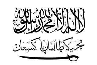
Hafiz Gul Bahadur is the leader of a Pakistani Taliban faction based in North Waziristan. Upon the formation of the Tehrik-i-Taliban Pakistan (TTP) in December 2007, he was announced as the militant group's overall naib amir under Baitullah Mehsud, who was based in South Waziristan, but has largely distanced himself from the TTP due to rivalries with Mehsud and disagreements about the TTP's attacks against the Pakistani state.

The 2010 Lakki Marwat suicide bombing occurred on 1 January 2010, in the village of Shah Hassan Khel, Lakki Marwat District, in the Khyber-Pakhtunkhwa province of Pakistan. At least 105 people died and over 100 were injured, many of them critically, when the suicide bomber blew up his sport utility vehicle filled with explosives in the middle of a crowd that had gathered to watch a volleyball game.

Jamaat-ul-Ahrar is a terrorist organization that split away from Tehrik-i-Taliban Pakistan in August 2014. The group came to prominence after it claimed responsibility for the 2014 Wagah border suicide attack. In October 2017, there were unconfirmed reports that Omar Khalid, the leader of the JuA, had died from injuries sustained in a US drone strike in Paktia Province, Afghanistan.

Khyber was the code-name for a military offensive conducted by Pakistan's military in the Khyber Agency in four phases; Khyber-1, Khyber-2, Khyber-3 and Khyber-4.

References

  1. 1 2 3 Manzoor, Ali (1 January 2011). "A village where people mourn the New Year". The Express Tribune.
  2. 1 2 3 4 5 6 Google (13 May 2013). "Shah Hassan Khel" (Map). Google Maps . Google. Retrieved 13 May 2013.
  3. 1 2 3 4 5 6 "Map of Marwat Tehsil". Khyber.org. Retrieved 13 May 2013.
  4. "Lakki Marwat singers face Taliban wrath". Daily Times Pakistan. 13 April 2007.
  5. Shah, Niaz A (2011). Islamic Law and the Law of Armed Conflict: The Conflict in Pakistan. Taylor & Francis. p. 129. ISBN   9781136824685.
  6. Chalk, Peter (2012). Encyclopedia of Terrorism. ABC-CLIO. pp. 406–407. ISBN   9780313308956.
  7. Shah, Zahir (30 March 2012). "Bombed Lakki Marwat school rebuilt". CentralAsiaOnline. Retrieved 13 May 2013.