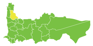
Al-Alani is a town in northwestern Syria, administratively part of the Idlib Governorate, just east of the Syrian-Turkish border. Nearby localities include Salqin and Isqat to the east. According to the Syria Central Bureau of Statistics, al-Alani had a population of 3,279 in the 2004 census.

Abu al-Duhur is a town in northwestern Syria on the edge of the Syrian Desert, administratively part of the Idlib Governorate, located about 45 kilometers south of Aleppo. Nearby localities include Tell Sultan and Tell Kalbah to the northwest. According to the Syria Central Bureau of Statistics (CBS), Abu al-Duhur had a population of 10,694 in the 2004 census. It is the center of a nahiyah ("subdistrict") containing 26 localities with a combined population of 38,869 in 2004.
Qasr al-Mukharram is a Syrian village located in the Suran Subdistrict in Hama District. According to the Syria Central Bureau of Statistics (CBS), Qasr al-Makhram had a population of 552 in the 2004 census.
Qubaybat Abu al-Huda is a Syrian village located in the Suran Subdistrict in Hama District. According to the Syria Central Bureau of Statistics (CBS), Qubaybat Abu al-Huda had a population of 402 in the 2004 census.
Al-Tulaysiyah al-Janubiyah is a Syrian village located in the Hirbnafsah Subdistrict in Hama District. According to the Syria Central Bureau of Statistics (CBS), al-Tulaysiyah al-Janubiyah had a population of 563 in the 2004 census.
Al-Anz is a Syrian hamlet located in al-Hamraa Subdistrict in Hama District. According to the Syria Central Bureau of Statistics (CBS), al-Anz had a population of 146 in the 2004 census.
Al-Aziziyah is a Syrian village located in Al-Hamraa Nahiyah in Hama District, Hama. According to the Syria Central Bureau of Statistics (CBS), Aziziyeh, Hama had a population of 533 in the 2004 census.. During Syria Civil War, Al-Aziziyah was captured by ISIS from Opposition, then on 6 February 2018, Al-Aziziyah was liberated by SAA.
Al-Qahirah, Hama is a Syrian village located in Qalaat al-Madiq Subdistrict in Al-Suqaylabiyah District, Hama. According to the Syria Central Bureau of Statistics (CBS), the village had a population of 708 in the 2004 census.
Khirbat al-Naqus is a Syrian village located in Al-Ziyarah Nahiyah in Al-Suqaylabiyah District, Hama. According to the Syria Central Bureau of Statistics (CBS), the village had a population of 1186 in the 2004 census.
Al-'Amrah is a Syrian village located in Al-Ziyarah Nahiyah in Al-Suqaylabiyah District, Hama. According to the Syria Central Bureau of Statistics (CBS), the village had a population of 575 in the 2004 census.
Jubb al-Ghar is a Syrian village located in Shathah Subdistrict in Al-Suqaylabiyah District, Hama. According to the Syria Central Bureau of Statistics (CBS), the village had a population of 821 in the 2004 census.
Al-Swaia is a Syrian village located in Al-Saan Subdistrict in Salamiyah District, Hama. According to the Syria Central Bureau of Statistics (CBS), Al-Swaia had a population of 68 in the 2004 census.
Rasm Al-Ahmar is a Syrian village located in Al-Saan Subdistrict, Salamiyah District, Hama. According to the Syria Central Bureau of Statistics (CBS), Rasm Al-Ahmar had a population of 754 in the 2004 census.
Abu Khanadeq is a Syrian village located in Sabburah Subdistrict in Salamiyah District, Hama. According to the Syria Central Bureau of Statistics (CBS), Abu Khanadeq had a population of 507 in the 2004 census.
Al-Sindiyana is a Syrian village located in Wadi al-Uyun Nahiyah in Masyaf District, Hama. According to the Syria Central Bureau of Statistics (CBS), al-Sindiyana had a population of 621 in the 2004 census.

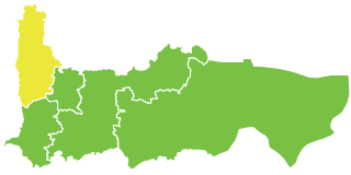
Jisr al-Shughur Nahiyah is a Syrian Nahiyah (Subdistrict) located in Jisr al-Shughur District in Idlib. According to the Syria Central Bureau of Statistics (CBS), Jisr al-Shughur Nahiyah had a population of 89028 in the 2004 census.
Zafar al-Kabir is a Syrian village located in Abu al-Duhur Nahiyah in Idlib District, Idlib. According to the Syria Central Bureau of Statistics (CBS), Zafar al-Kabir had a population of 444 in the 2004 census.
Raffa is a Syrian village located in Al-Tamanah Nahiyah in Maarrat al-Nu'man District, Idlib. According to the Syria Central Bureau of Statistics (CBS), Raffa had a population of 1188 in the 2004 census.
Al-Marj Al-Akhdar Al-Sharqi is a Syrian village located in Jisr al-Shughur Nahiyah in Jisr al-Shughur District, Idlib. According to the Syria Central Bureau of Statistics (CBS), Al-Marj Al-Akhdar Al-Sharqi had a population of 4424 in the 2004 census.
Al-Arien is a Syrian village located in Jisr al-Shughur Nahiyah in Jisr al-Shughur District, Idlib. According to the Syria Central Bureau of Statistics (CBS), Al-Arien had a population of 663 in the 2004 census.