
Mau, also now known as Maunath Bhanjan, is an industrial town and the headquarter of the Mau district. It is located in the eastern part of Uttar Pradesh, India. The town is known for its saree industry which is a traditional business and centuries old art of the people of this city.
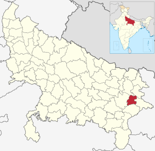
Mau district is one of the districts of Uttar Pradesh state of India, and Mau town is the district headquarters which is also one of the few remaining areas of handloom saree production in eastern Uttar Pradesh, specializing in Sadiya silk sarees. Mau was carved out as a separate district from Azamgarh on 19 November 1988. It is situated in the south-eastern part of the state with headquarters in Maunath Bhanjan. The district is surrounded by Ghazipur district on the south, Ballia district in the east, Azamgarh district in the west, and by Gorakhpur and Deoria districts on the north.
Khairabad is a census town in Mau district, in the eastern part of Uttar Pradesh, India. It is located on the Mau-Azamgarh route, adjacent to Muhammadabad Gohna.
The demographics of Uttar Pradesh is a complex topic, which is undergoing dynamic change. Uttar Pradesh is India's most populous state, and the largest subdivision in the world. It has a population of about 199,812,341 as per the 2011 census. If it were a separate country, Uttar Pradesh would be the world's fifth most populous nation, next only to China, India, the United States of America and Indonesia. Uttar Pradesh has a population more than that of Pakistan. There is an average population density of 828 persons per km² i.e. 2,146 per sq mi. The capital of Uttar Pradesh is Lucknow, and Allahabad serves as the state’s judicial capital. Hindus and Muslims both consider the state as a holy place.
Fatehpur Talratoy is a village located in Madhuban tehsil of Mau district in Uttar Pradesh, India. It has total 196 families residing. Fatehpur Talratoy has population of 1324 as per government records.
Walidpur is a village in Meerut district in the Indian state of Uttar Pradesh.
Bhadsa Manopur is a village located in Maunath Bhanjan tehsil of Mau district, Uttar Pradesh. It has total 494 families residing. Bhadsa Manopur has population of 3,623 as per government records. This village is located at a distance of 11 km towards north from district headquarter Mau. The village is well connected with nearby towns as it situated on the Varanasi-Gorakhpur Highway.
Kasara is a village located in Maunath Bhanjan tehsil of Mau district, Uttar Pradesh. It has total 922 families residing. Kasara has population of 6,047 as per government records.
Dhanauli Rampur is a village located in Ghosi tehsil of Mau district, Uttar Pradesh. It has total 530 families residing. Dhanauli Rampur has population of 3,452 as per government records.
Bhadon is a village and Gram Panchayat located in Martinganj tehsil of the Azamgarh District in the Indian state of Uttar Pradesh, near the border with Jaunpur District. It is 37.7 kilometres (23.4 mi) north-east of the district headquarters in Azamgarh and 229.9 kilometres (142.9 mi) from the state capital of Lucknow.

Murarmau is a village in Sareni block of Rae Bareli district, Uttar Pradesh, India. It is located 21 km from Lalganj, the tehsil headquarters. Murarmau historically served as the seat of the largest taluqdar estate in the district, held by the most senior branch of the Tilokchandi Bais. As of 2011, it has a population of 2,999 people, in 523 households. It has one primary school and no healthcare facilities. Murarmau serves as the headquarters of a nyaya panchayat which also includes 9 other villages.

Mansukhmau is a village in Dalmau block of Rae Bareli district, Uttar Pradesh, India. It is located 9 km from Dalmau, the block headquarters. As of 2011, it has a population of 394 people, in 65 households. It has no schools and no healthcare facilities.

Abdu Mau, also spelled Abdumau, is a village in Chhatoh block of Rae Bareli district, Uttar Pradesh, India. It is located 48 km from Raebareli, the district headquarters. As of 2011, the village has a population of 1,339 people, in 213 households. It has one primary school and no healthcare facilities. It belongs to the nyaya panchayat of Paraiya Namaksar.
Kunwarmau is a village in Chhatoh block of Rae Bareli district, Uttar Pradesh, India. It is located 11 km from Jais, the nearest large town. As of 2011, Kunwarmau has a population of 5,184 people, in 992 households. It has one primary school and no healthcare facilities.
Mau is a large village in Dih block of Rae Bareli district, Uttar Pradesh, India. It is located on the road from Fursatganj to the Gukana ghat on the Ganges, 4 miles west of Nasirabad and 8 miles from Jais. A road branches off at Mau and connects to Nasirabad. To the northwest of the village is a large lake called the Bara Tal.
Rokha is a large village in Dih block of Rae Bareli district, Uttar Pradesh, India. Historically the namesake of a pargana, Rokha is a predominantly agricultural village consisting of many hamlets. It is located 28 km from Raebareli, the district headquarters. The large village of Mau also borders Rokha to the north. Rokha is connected by road with Nasirabad and Jais to the northeast and Suchi to the southwest.

Golhamau is a village in Lalganj block of Rae Bareli district, Uttar Pradesh, India. It is located 6 km from Lalganj, the block and tehsil headquarters. As of 2011, it has a population of 360 people, in 61 households. It has no schools and no healthcare facilities, and it does not host a permanent market or a weekly haat. It belongs to the nyaya panchayat of Bahuria Khera.
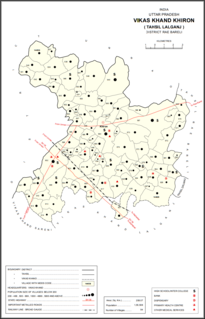
Chandemau is a village in Khiron block of Rae Bareli district, Uttar Pradesh, India. It is located 18 km from Lalganj, the tehsil headquarters. As of 2011, it has a population of 1,135 people, in 230 households. It has 1 primary school and no healthcare facilities and it does not host a weekly haat or a permanent market. It belongs to the nyaya panchayat of Bhitargaon.
Miramau is a village in Khiron block of Rae Bareli district, Uttar Pradesh, India. It is located 14 km from Lalganj, the tehsil headquarters. As of 2011, it has a population of 1,057 people, in 228 households. It has 1 primary school and no healthcare facilities and it does not host a weekly haat or a permanent market. It belongs to the nyaya panchayat of Bhitargaon.
Tikwamau is a village in Khiron block of Rae Bareli district, Uttar Pradesh, India. It is located 15 km from Lalganj, the tehsil headquarters. As of 2011, it has a population of 1,065 people, in 201 households. It has 1 primary school and no healthcare facilities and it hosts both a weekly haat and a permanent market. It is the headquarters of a nyaya panchayat which also includes 8 other villages.

