Shawneehaw Creek

Last updated
Shawneehaw Creek
Shawneehaw Creek in Banner Elk.jpg
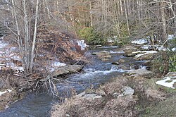
Shawneehaw Creek
from Shawneehaw Ave. in Banner Elk
Location
Country United States
State North Carolina
Counties Watauga, Avery
Physical characteristics
Source 
  location Watauga County, NC
  coordinates 36°11′11″N81°50′43″W / 36.18639°N 81.84528°W / 36.18639; -81.84528
Mouth Elk River
  location
Avery County, NC
  coordinates
36°09′28″N81°52′15″W / 36.15778°N 81.87083°W / 36.15778; -81.87083 Coordinates: 36°09′28″N81°52′15″W / 36.15778°N 81.87083°W / 36.15778; -81.87083
  elevation
3,638 ft (1,109 m)
Length2.99 mi (4.81 km) [1]
Basin features
River system Watauga River
Tributaries 
  rightShoemaker Creek

The Shawneehaw Creek [2] is a stream in the North Carolina High Country and is named after a Cherokee word for a tree that blooms early in the Spring, the current name for the tree is Serviceberry, or sarvisberry, and is located in the town of Banner Elk. The headwaters begin from the Southeastern slopes of Beech Mountain in Watauga County, North Carolina and end at the Elk River in Avery County, North Carolina.The tree extend from North Carolina to Louisiana and Florida, and to 6000 feet.

Contents

Hydrography

With the headwaters beginning from the Southeastern slopes of Beech Mountain (nearby Shawnee Road/SR 1127). It flows to NC 194 (Balm Highway/Main Street), then changes direction to Southwest and connects with Shoemaker Creek as it enters the town limits of Banner Elk. It goes parallel with NC 194 before it bends left and cuts through the Banner Elk park area, eventually reaching NC 184 (Tynecastle Highway/Shawneehaw Avenue). The creek ends as it flows into the Mill Pond and joins the Elk River.

The water eventually flows through the Elk River, the Watauga River, the Holston River, the Tennessee River, the Ohio River, and the Mississippi River to the Gulf of Mexico.

Stream Restoration

Since 2000, the Shawneehaw Creek has been undergoing stream restoration, enhancement and stabilization. [3] With grant money from the Clear Water Management Trust Fund, the project is going to provide vegetated riparian buffer that are going to improve the water quality and return the creek to a more natural state. The North Carolina State University extension office, the town of Banner Elk, and the local property owners are the main players of the project. [4]

Related Research Articles

Watauga County, North Carolina U.S. county in North Carolina

Watauga County is a county located in the U.S. state of North Carolina. As of the 2010 census, the population was 51,079. Its county seat and largest town is Boone. The county is in an exceptionally mountainous region. It is the home of Appalachian State University, which has approximately 15,000 students.

Avery County, North Carolina U.S. county in North Carolina

Avery County is a county located in the U.S. state of North Carolina. As of the 2010 census, the population was 17,797. The county seat is Newland. The county seat was initially established in Elk Park when the county was first formed, but was moved to Newland upon completion of the courthouse in 1912. Founded in 1911, it is the youngest of North Carolina's 100 counties.

Ashe County, North Carolina U.S. county in North Carolina

Ashe County is a county located in the U.S. state of North Carolina. As of the 2010 census, the population was 27,281. Its county seat is Jefferson.

Banner Elk, North Carolina Town in North Carolina, United States

Banner Elk is a town in Avery County, North Carolina, United States. The population was 1,028 at the 2010 census. Banner Elk is home to Lees–McRae College.

A spring creek is a stream that flows from a spring.

Cullasaja River Stream in North Carolina, USA

The Cullasaja River is a short river located entirely in Macon County, North Carolina. It is a tributary of the Little Tennessee River into which it flows near the county seat of Franklin.

French Broad River River in North Carolina and Tennessee, United States

The French Broad River flows 218 miles (351 km) from near the town of Rosman in Transylvania County, North Carolina, into the state of Tennessee. Its confluence with the Holston River at Knoxville is the beginning of the Tennessee River. The river flows through the counties of Transylvania, Buncombe, Henderson, and Madison in North Carolina, and Cocke, Jefferson, Sevier, and Knox in Tennessee. It drains large portions of the Pisgah National Forest and the Cherokee National Forest.

Catawba River

The Catawba River originates in Western North Carolina and flows into South Carolina, where it is known as the Wateree River. The river is approximately 220 miles (350 km) long. It rises in the Appalachian Mountains and drains into the Piedmont, where it has been impounded through a series of reservoirs for flood control and generation of hydroelectricity. The river is named after the Catawba tribe of Native Americans, which lives on its banks. In their language, they call themselves "yeh is-WAH h’reh", meaning "people of the river."

Nolichucky River

The Nolichucky River is a 115-mile (185 km) river that flows through Western North Carolina and East Tennessee, in the southeastern United States. Traversing the Pisgah National Forest and the Cherokee National Forest in the Blue Ridge Mountains, the river's watershed is home to some of the highest mountains in the Appalachians, including Mount Mitchell in North Carolina, the highest point in the eastern United States. The river is a tributary of the French Broad River, and is impounded by Nolichucky Dam near Greeneville, Tennessee.

Elk River (Tennessee River tributary)

The Elk River is a tributary of the Tennessee River in the U.S. states of Tennessee and Alabama. The river is about 195 miles (314 km) long.

Swannanoa River Stream in North Carolina, USA

The Swannanoa River flows through the Swannanoa Valley of the region of Western North Carolina, and is a major tributary to the French Broad River. Its headwaters arise in Black Mountain, NC; however, it also has a major tributary near its headwaters: Flat Creek, which begins on the slopes of Mount Mitchell. The Swannanoa River ends at its confluence with the French Broad, now within the grounds of the 8,000-acre Biltmore Estate in Asheville.

Elk River (North Carolina–Tennessee)

The Elk River is a large stream in the North Carolina High Country and East Tennessee. The headwaters begin from the Northwestern slopes of Peak Mountain in Avery County, North Carolina and end at the Watauga River in Carter County, Tennessee.

Western North Carolina

Western North Carolina is the region of North Carolina which includes the Appalachian Mountains; it is often known geographically as the state's Mountain Region. It contains the highest mountains in the Eastern United States, with 125 peaks rising to over 5,000 feet elevation. Western North Carolina is sometimes included with upstate South Carolina as the "Western Carolinas", which is counted as a single media market. The region covers an area of about 11,000 square miles (28,000 km2), and is roughly the size of the state of Massachusetts. The population of the region, as measured by the 2010 U.S. Census, is 1,473,241, which is approximately 15% of North Carolina's total population.

North Fork Feather River

The North Fork Feather River is a watercourse of the northern Sierra Nevada in the U.S. state of California. It flows generally southwards from its headwaters near Lassen Peak to Lake Oroville, a reservoir formed by Oroville Dam in the foothills of the Sierra, where it runs into the Feather River. The river drains about 2,100 square miles (5,400 km2) of the western slope of the Sierras. By discharge, it is the largest tributary of the Feather.

Elk Knob State Park

Elk Knob State Park is a 4,423-acre (17.90 km2) North Carolina state park in Watauga County, North Carolina, in the United States. Opened in 2003, it is one of North Carolina's newest state parks. Elk Knob State Park was established to preserve the natural state of Elk Knob, the second highest peak in Watauga County. The park is open for year-round recreation and is currently undergoing an expansion of facilities to provide greater recreational opportunities to visitors. Elk Knob State Park is on Meat Camp Road, 5.5 miles (8.9 km) from North Carolina Highway 194, 9.5 miles (15.3 km) north of Boone, in the Blue Ridge Mountains.

Peak Mountain (North Carolina)

Peak Mountain is a mountain in the North Carolina High Country, near the town of Seven Devils. It is wholly in the Pisgah National Forest. Its elevation reaches 4,921 feet (1,500 m).

North Carolina Highway 184

North Carolina Highway 184 (NC 184) is a primary state highway in the U.S. state of North Carolina. It runs from NC 105 at Tynecastle to the town of Beech Mountain.

North Carolina Highway 194

North Carolina Highway 194 (NC 194) is a primary state highway in the U.S. state of North Carolina. Primarily in the High Country, it runs from US 19E, in Ingalls, to the Virginia state line, near Helton.

Bear Creek (Neuse River tributary)

Bear Creek is a tributary of the Neuse River in North Carolina, USA. It drains an area of intensive agriculture, and is heavily polluted with nitrates.

References

  1. "Eagle Swamp Watershed Report". US EPA Geoviewer. US EPA. Retrieved December 29, 2020.
  2. U.S. Geological Survey Geographic Names Information System: Shawneehaw Creek
  3. "NC Stream Restoration Institute - Shawneehaw".
  4. "Projects for improving the Town of Banner Elk, North Carolina".