
Bleecker is a town in Fulton County, New York, United States. The population was 533 at the 2010 census. The name is from Barent Bleecker, one of the original landowners of the region.

Caroga is a town in Fulton County, New York, United States. The population was 1,205 at the 2010 census. The town was named after a local creek.

Arietta is a town in Hamilton County, New York, United States. The population was 292 at the 2020 census. The town was named after the mother of one of the first settlers, Rensselaer Van Rennslaer.

Benson is a town in Hamilton County, New York, United States. The population was 221 at the 2020 census. The town is on the southern border of Hamilton County and is northwest of Schenectady. The current Town Supervisor is John M. Stortecky.

Ohio is a town in Herkimer County, New York, United States. The population was 1,002 at the 2010 census. The town is named after the state of Ohio. The town is in the northern part of the county and northeast of Utica. Part of Ohio is within the Adirondack Park.

New York State Route 10 (NY 10) is a north–south state highway in the Central New York and North Country regions of New York in the United States. It extends for 155 miles (249 km) from the Quickway (NY 17) in Deposit, Delaware County to NY 8 at Higgins Bay, a hamlet in the Hamilton County town of Arietta. NY 10 begins concurrent with NY 8. While NY 8 follows a more westerly alignment between Deposit and Higgins Bay via Utica, NY 10 veers to the east, serving Delhi, Cobleskill, and Canajoharie. Along the way, the road intersects Interstate 88 (I-88) near Cobleskill and U.S. Route 20 (US 20) in Sharon Springs.

New York State Route 309 (NY 309) is a 6.56-mile-long (10.56 km) state highway located entirely in Fulton County, New York, in the United States. The southern terminus of the route is at an intersection with NY 29A in Gloversville. The northern terminus of the route is at a junction with Lily Lake Road in the hamlet of Bleecker, where the highway continues north and west as County Route 112 (CR 112) to London Bridge Road at West Caroga Lake in the town of Caroga. Part of NY 309 and all of CR 112 is located within Adirondack Park. NY 309 was assigned to its current alignment as part of the 1930 renumbering of state highways in New York.

Mount Saint John, height 11,435 feet (3,485 m), is located in the Teton Range, Grand Teton National Park, Wyoming, northwest of Jenny Lake. The mountain towers above the northwest shore of Jenny Lake, and along with Symmetry Spire and Rockchuck Peak, form a massif which looms to the north above Cascade Canyon. The scenic Lake of the Crags, a cirque lake or tarn, is located immediately south of the summit and is accessed by way of Hanging Canyon.

Hadley Mountain is a mountain located in the southern Adirondacks in the U.S. state of New York and is the second-highest peak in Saratoga County after neighboring Tenant Mountain. The Hadley Mountain Fire Observation Station was listed on the National Register of Historic Places on September 23, 2001 for its role as a Fire lookout tower with the New York State Forest Preserve. Hadley Mountain is the highest of the three peaks that form the West Mountain ridge.

Caroga Lake is an unincorporated community and census-designated place (CDP) in the town of Caroga, Fulton County, New York, United States. The population was 518 at the 2010 census. The hamlet is in the southern part of the town of Caroga and is northwest of Gloversville. Two lakes, West Caroga Lake and East Caroga Lake are located next to the hamlet.
Caroga Creek is a river in Fulton and Montgomery counties in the U.S. State of New York. It begins at East Caroga Lake and flows south passing through Rockwood Lake before converging with the Mohawk River in the Hamlet of Palatine Church.
East Caroga Lake is located in the Town of Caroga by Caroga Lake, New York. The lake provides excellent warm water fishing and rainbow trout fishing. The lake is connected to West Caroga Lake by a small channel. Origin of the name, "Caroga" is derived from the once nearby Indian Village known as "Caroga".

Canada Lake is located in the Town of Caroga in Fulton County in the U.S. state of New York. Unlike the nearby Caroga lakes, Canada Lake is very deep which provides colder water for species such as trout to survive. There is an annual draw down on the lake by way of a control structure on the outlet of Stewart Landing. The impoundment of this water has created a lake complex of Lily Lake, Canada Lake, West Lake and Green Lake.

Sprite Creek is a river in Fulton County and Herkimer County in the U.S. State of New York. It begins at Canada Lake northwest of the Hamlet of Caroga Lake, and flows through Lily Lake before converging with the East Canada Creek northeast of the Village of Dolgeville.

Rum Hill is a mountain located in Central New York Region of New York northwest of the Hamlet of Pierstown. Red House Hill is located southeast, Metcalf Hill is located south, Allen Lake and Mohegan Hill are located north-northwest and Otsego Lake is located east of Rum Hill.

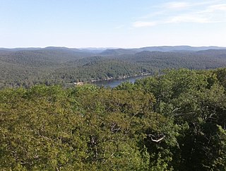
Kane Mountain is a mountain in the Adirondack Mountains region of New York. It is located north of the Hamlet of Canada Lake. The Kane Mountain Fire Observation Station is located on top of the mountain. Sheeley Mountain is located south-southwest, Canada Lake is located south, Camelhump is located east and Pine Lake is located north of Kane Mountain.

Camelhump is a mountain in the Adirondack Mountains region of New York. It is located north-northwest of the Hamlet of Caroga Lake. Kane Mountain is located west, Canada Lake is located southwest and Stewart Lake is located east of Camelhump.
Pine Lake is a reservoir in Fulton County in the U.S. State of New York. It is located in the Town of Caroga north of the Hamlet of Canada Lake. Kane Mountain is located south and Pine Mountain is located east of Pine Lake.


