
Ghana is a West African country in Africa, along the Gulf of Guinea.
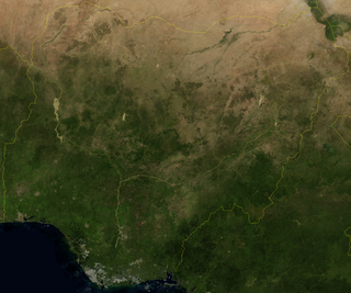
Nigeria is a country in West Africa, it shares land borders with the Republic of Benin to the west, Chad and Cameroon to the east, and Niger to the north. Its coast lies on the Gulf of Guinea in the south and it borders Lake Chad to the northeast. Notable geographical features in Nigeria include the Adamawa Plateau, Mambilla Plateau, Jos Plateau, Obudu Plateau, the Niger River, Benue River, and Niger Delta.
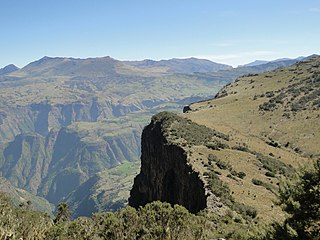
Ethiopia is located in the Horn of Africa. It is bordered by Eritrea to the north, Djibouti and Somalia to the east, Sudan and South Sudan to the west, and Kenya to the south. Ethiopia has a high central plateau that varies from 1,290 to 3,000 m above sea level, with the highest mountain reaching 4,620 m (15,157 ft).

The Iranian plateau or Persian plateau is a geological feature in Western Asia, Central Asia, and South Asia. It comprises part of the Eurasian Plate and is wedged between the Arabian Plate and the Indian Plate; situated between the Zagros Mountains to the west, the Caspian Sea and the Köpet Dag to the north, the Armenian Highlands and the Caucasus Mountains to the northwest, the Strait of Hormuz and the Persian Gulf to the south, and the Indian subcontinent to the east.

In geology and physical geography, a plateau, also called a high plain or a tableland, is an area of a highland consisting of flat terrain that is raised sharply above the surrounding area on at least one side. Often one or more sides have deep hills or escarpments. Plateaus can be formed by a number of processes, including upwelling of volcanic magma, extrusion of lava, and erosion by water and glaciers. Plateaus are classified according to their surrounding environment as intermontane, piedmont, or continental. A few plateaus may have a small flat top while others have wide ones.
Highlands or uplands are areas of high elevation such as a mountainous region, elevated mountainous plateau or high hills. Generally speaking, upland refers to ranges of hills, typically from 300 m (980 ft) up to 500–600 m (1,600–2,000 ft) while highland is usually reserved for ranges of low mountains. However, the two terms are sometimes interchangeable.
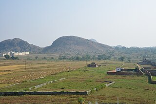
The Chota Nagpur Plateau is a plateau in eastern India, which covers much of Jharkhand state as well as adjacent parts of Chhattisgarh, Odisha, West Bengal and Bihar. The Indo-Gangetic plain lies to the north and east of the plateau, and the basin of the Mahanadi river lies to the south. The total area of the Chota Nagpur Plateau is approximately 65,000 square kilometres (25,000 sq mi).
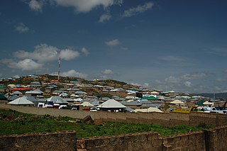
Jos is a city in the north central region of Nigeria. The city has a population of about 900,000 residents based on the 2006 census. Popularly called "J-Town", it is the administrative capital and largest city of Plateau State.

Plateau State is the twelfth-largest Nigerian state. It is in the centre of the country includes a range of hills surrounding the Jos Plateau, its capital, and the entire plateau itself.

Nasarawa State is a state in the North Central region of Nigeria, bordered to the east by the states of Taraba and Plateau, to the north by Kaduna State, to the south by the states of Kogi and Benue, and to the west by the Federal Capital Territory. Named for the historic Nasarawa Emirate, the state was formed from the west of Plateau State on 1 October 1996. The state has thirteen local government areas and its capital is Lafia, located in the east of the state, while a key economic centre of the state is the Karu Urban Area—suburbs of Abuja—along the western border with the FCT.

The Jos Plateau is a plateau located near the centre of Nigeria. The plateau has given its name to the Plateau State in which it is found and is named for the state's capital, Jos. The plateau is home to people of diverse cultures and languages. The plateau's montane grasslands, savannas, and forests are home to communities of plants and animals distinct from those of the surrounding lowlands and constitute the Jos Plateau forest-savanna mosaic ecoregion.
Bukuru is a city located on the Jos Plateau in Nigeria. It was previously considered a separate city from the city of Jos close by, but like every other form of urbanization, the city of Jos has merged with the town of Bukuru to form the Jos-Bukuru metropolis. It is the headquarters of Jos South Local Government Area.
The Palani Hills Wildlife Sanctuary and National Park is a proposed protected area in Dindigul District, Tamil Nadu India. The park will be an upgrade and expansion of the 736.87 km2(PRO) Palani (Kodaikanal) Wildlife Sanctuary which was to be established in 2008. The park includes about 36% of the 2,068 square kilometres (798 sq mi) in the Palani Hills. The park is located between latitude 10°7' - 10°28' N and longitude 77°16' - 77°46' E. Central location is 1.5 kilometres (0.93 mi) east northeast of Silver Cascade Waterfall and 4 kilometres (2.5 mi) E X NE of Kodaikanal Lake.

The Cameroonian Highlands forests, also known as the Cameroon Highlands forests, are a montane tropical moist broadleaf forest ecoregion located on the range of mountains that runs inland from the Gulf of Guinea and forms the border between Cameroon and Nigeria. This is an area of forest and grassland which has become more populous as land is cleared for agriculture.

The wildlife of Nigeria consists of the flora and fauna of this country in West Africa. Nigeria has a wide variety of different habitats, ranging from mangrove swamps and tropical rainforest to savanna with scattered clumps of trees. About 290 species of mammal and 940 species of bird have been recorded in the country.

The Mambilla Plateau is a plateau in the Taraba State of Nigeria. The Mambilla Plateau has an average elevation of about 1,600 metres (5,249 ft) above sea level, making it the highest plateau in Nigeria. Some of its villages are situated on hills that are at least 1,828 metres (5,997 ft) above sea level. Some mountains on the plateau and around it are over 2,000 metres (6,562 ft) high, like Gang or Chappal Waddi which has a height of 2,419 metres (7,936 ft) above sea level. It is the highest mountain in Nigeria and in West Africa. The Mambilla Plateau measures about 96 km (60 mi) along its curved length; it is 40 km (25 mi) wide and is bounded by an escarpment that is about 900 m (2,953 ft) high in some places. The plateau covers an area of over 9,389 square kilometres (3,625 sq mi).
Farin Ruwa Falls is a waterfall found in the central region of Nigeria. It is among the highest waterfalls in Nigeria. It is significant among Africa's falls when the total height covered by the waterfall is considered.
The Shere Hills are a range of undulating hills and rock formations on the Jos Plateau, situated about 10 km east of the Jos metropolis, the capital of Plateau State in the Middle Belt region of Nigeria.
The Afizere people are an ethnic group that occupy Jos East, Jos North, parts of Jos South and Mangu Local Government Areas of Plateau State and parts of Toro and Tafawa Balewa Local Government Areas of Bauchi State, Nigeria. The Afizere are speakers of Izere language. The neighbors of the Afizere to the north are the Hausa and Jarawan Dass. To the East and South East are the Zari, Sayawa and Pyem. To the South and South- West are the Berom while the Irigwe and Rukuba lie to the West. On to the North-west of the Afizere are found a number of ethnic groups the closest of which are the Anaguta, Bujel, Ribina, Kayauri and Duguza while the more distant ones include Buji, Gusu, Sanga, Jere, Amoa and Lemoro.
Ntoroko is a town officially known as Kanara Town Council in Ntoroko District Western Uganda. It is one of the four town councils of Ntoroko District the others being Karugutu, Rwebisengo and Kibuku Town Council. Ntoroko is the largest fishing town on the southern Mwitanzige shore. Its located on the Ntoroko bay extending from Kanara Fishing village to the western half of the Ntoroko Peninsula. The peninsular also separates Ntoroko bay from the Muziizi Bay. By Road, Ntoroko town is approximately 84 KM Northwest of Fort Portal City, the regional Capital and approximately 79 KM via Karugutu, north of Kibuku Town Council the District Capital. Ntoroko/Kanara Town Council is settled by many ethnicities, the largest being; Rwenzori Peoples; Batooro/Batuku, Bakonzo, Bamba, Babwisi. Bunyoro peoples; Bagangaizi,Bagungu and other Banyoro. Alur, Lendu and Ngite. Congolese of the Western Mwitanzige shore; Alur, Gegere, Nande, to mention but a few.
