
Nevada is a state in the Western region of the United States. It is bordered by Oregon to the northwest, Idaho to the northeast, California to the west, Arizona to the southeast, and Utah to the east. Nevada is the 7th-most extensive, the 19th-least populous, and the 9th-least densely populated of the U.S. states. Nearly three-quarters of Nevada's people live in Clark County, which contains the Las Vegas–Paradise metropolitan area, including three of the state's four largest incorporated cities. Nevada's capital is Carson City.

White Pine County is a largely rural, mountain county along the central eastern boundary of the U.S. state of Nevada. As of the 2010 census, the population was 10,030. Its county seat is Ely. The name "(Rocky Mountain) white pine" is an old name for the limber pine, a common tree in the county's mountains.
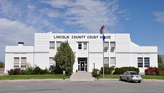
Lincoln County is a county located in the U.S. state of Nevada. As of the 2010 census, the population was 5,345. Its county seat is Pioche. Like many counties in Nevada, it is dry and sparsely populated, though notable for containing the Area 51 government Air Force base.

Mount Whitney is the highest mountain in the contiguous United States and the Sierra Nevada, with an elevation of 14,505 feet (4,421 m). It is in East–Central California, on the boundary between California's Inyo and Tulare counties, 84.6 miles (136.2 km) west-northwest of North America's lowest point, Badwater Basin in Death Valley National Park, at 282 ft (86 m) below sea level. The mountain's west slope is in Sequoia National Park and the summit is the southern terminus of the John Muir Trail, which runs 211.9 mi (341.0 km) from Happy Isles in Yosemite Valley. The eastern slopes are in Inyo National Forest in Inyo County.

Mount Charleston, including Charleston Peak at 11,916 feet (3,632 m), is the highest mountain in both the Spring Mountains and Clark County, in Nevada, United States. It is the eighth-highest mountain in the state. Well separated from higher peaks by large, low basins, Charleston Peak is the most topographically prominent peak in Nevada, and the eighth-most-prominent peak in the contiguous United States. It is one of eight ultra-prominent peaks in Nevada. It is located about 35 miles (56 km) northwest of Las Vegas within the Mount Charleston Wilderness, which is within the Spring Mountains National Recreation Area of the Humboldt–Toiyabe National Forest.

Inyo National Forest is a United States National Forest covering parts of the eastern Sierra Nevada of California and the White Mountains of California and Nevada. The forest hosts several superlatives, including Mount Whitney, the highest point in the contiguous United States; Boundary Peak, highest point in Nevada; and the Ancient Bristlecone Pine Forest that protects the oldest trees in the world. The forest, encompassing much of Owens Valley, was established by Theodore Roosevelt as a way of sectioning off land to accommodate the Los Angeles Aqueduct project in 1907, making the Inyo National Forest one of the least wooded forests in the United States' system.

Mount Jefferson is the highest mountain in both the Toquima Range and Nye County in Nevada, United States. It is the sixth highest mountain in the state. As the high point of a range which is well separated from other ranges by low basins, Mount Jefferson has a high topographic prominence of 5,861 feet (1,786 m). This makes it the most prominent peak in Nye County and the third most prominent peak in Nevada. For similar reasons, it is also the highest mountain for over 90 miles in all directions. It is located about 50 miles (80 km) northeast of the county seat of Tonopah within the Alta Toquima Wilderness of the Humboldt-Toiyabe National Forest, near the smaller towns of Carvers and Round Mountain. Three distinct summits are located on a broad area of subalpine tundra: North Summit rises to 11,820 feet (3,603 m), Middle Summit to 11,692 feet (3,564 m), and South Summit to 11,949 feet (3,642 m). During the Pleistocene, alpine glaciers eroded several cirques east of the summit plateau.

Solar power in Nevada is growing due to a Renewable Portfolio Standard which requires 20% renewable energy by 2015, and 5% from solar power. The state has abundant open land areas and some of the best solar potential in the country.

The Mountain States form one of the nine geographic divisions of the United States that are officially recognized by the United States Census Bureau. It is a subregion of the Western United States.

Mount Grant is both the highest and most topographically prominent mountain in both the Wassuk Range and Mineral County in Nevada, United States. It ranks thirteenth among the most topographically prominent peaks in the state. The peak is located within the Hawthorne Army Depot, resulting in very limited public access.

Star Peak is both the highest and most topographically prominent mountain in both the Humboldt Range and Pershing County in Nevada, United States. It is the sixth-most topographically prominent peak in Nevada. The peak is on public land administered by the Bureau of Land Management and has no access restrictions.

Middle Sister is a mountain in the Sweetwater Mountains of Mono County, California, United States. It is located within the Humboldt-Toiyabe National Forest. The northeast ridge crosses into Lyon County in Nevada, making that location the Lyon County's highest point at about 10,565 feet (3,220 m).

Mount Augusta is the highest mountain in the Clan Alpine Mountains of Churchill County in Nevada, United States. It is the most topographically prominent peak in Churchill County and ranks nineteenth among the most topographically prominent peaks in Nevada. The peak is on public land administered by the Bureau of Land Management and thus has no access restrictions.
Mount Siegel is the highest mountain in the Pine Nut Mountains of Douglas County in Nevada, United States. It is the most topographically prominent peak in Douglas County and ranks forty-sixth among the most topographically prominent peaks in Nevada. The peak is on public land administered by the Bureau of Land Management and thus has no access restrictions.
Piper Peak is the highest mountain in the Silver Peak Range of Esmeralda County in Nevada, United States. It is the most topographically prominent peak in Esmeralda County and ranks twenty-third among the most topographically prominent peaks in Nevada. The peak is on public land administered by the Bureau of Land Management and thus has no access restrictions.
Mormon Peak is the highest mountain in the Mormon Mountains of Lincoln County in Nevada, United States. It is the most topographically prominent peak in Lincoln County and ranks twenty-fourth among the most topographically prominent peaks in Nevada. The peak is on public land administered by the Bureau of Land Management and thus has no access restrictions.
Bald Mountain is the highest mountain in the Pine Grove Hills of Lyon County in Nevada, United States. It is the most topographically prominent peak in Lyon County and ranks eighty-second among the most topographically prominent peaks in Nevada. The peak is located within the Humboldt-Toiyabe National Forest.
Virginia Peak is the highest mountain in the Pah Rah Range of Washoe County in Nevada, United States. It is the most topographically prominent peak in Washoe County and ranks thirty-sixth among the most topographically prominent peaks in Nevada. The peak is on public land administered by the Bureau of Land Management and thus has no access restrictions. A National Weather Service NEXRAD doppler weather radar station is located on the summit.
Mount Tobin is the highest mountain in the Tobin Range of Pershing County in Nevada, United States. It is the second-most topographically prominent peak in Pershing County and ranks twelfth among the most topographically prominent peaks in Nevada. The peak is on public land administered by the Bureau of Land Management and thus has no access restrictions, though private property is located along the most popular route to the summit.
Grapevine Peak is the highest mountain in the Grapevine Mountains of Nye County in Nevada, United States. It is the fourth-most topographically prominent peak in Nye County and ranks seventeenth among the most topographically prominent peaks in Nevada. The peak is located within the boundaries of Death Valley National Park.
