
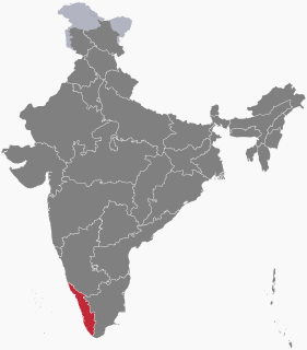
Idukki is one of the 14 districts of Kerala state, India, created on 26 January 1972 bifurcating Kottayam District. At that time, the district headquarters was at Kottayam. In June 1976 it was moved to Painavu. Idukki lies in the Western Ghats of Kerala. Idukki is the second largest district in area but has the lowest population density. Idukki has a vast forest reserve area; more than a half of the district is covered by forests. The urban areas are densely populated whereas villages are sparsely populated. Idukki is also known as the spice garden of Kerala.

Nadia district is a district in the state of West Bengal, in eastern India. It borders Bangladesh to the east, North 24 Parganas and Hooghly districts to the south, Purba Bardhaman to the west, and Murshidabad to the north.
Elections in Kerala are regularly held to fill government officials at all levels of government in both Kerala and India as a whole. These range from national elections to regional local body or panchayat elections. The Assembly of Kerala creates laws regarding the conduct of local body elections unilaterally while any changes by the state legislature to the conduct of state level elections need to be approved by the Parliament of India. In addition, the state legislature may be dismissed by the Parliament according to Article 356 of the Indian Constitution and President's rule may be imposed.

South 24 Parganas or sometimes South Twenty Four Parganas is a district in the Indian State of West Bengal, headquartered in Alipore. It is the largest district of West Bengal state by area and second largest by population. It is the sixth most populous district in India. On one side is the urban fringe of Kolkata and on the other, the remote riverine villages in the Sundarbans.

Tiruchirapalli District is located along the Kaveri River in Tamil Nadu, India. The main town in Tiruchirappalli District is the city of Tiruchirappalli, also known as Trichy. During the British Raj, Tiruchirappalli was known as Trichinopoly, and was a district of the Madras Presidency; it was renamed upon India's declaration of independence in 1947. As of 2011, the district had a population of 2,722,290 with 1,013 females for every 1,000 males.
A sarpanch is a decision-maker, elected by the village-level constitutional body of local self-government called the Gram Sabha in India. The sarpanch, together with other elected pancha (members), constitute the gram panchayat. The sarpanch is the focal point of contact between government officers and the village community.
A town panchayat or panchayat is a small town of approximately 20,000 to 25,000 inhabitants. It is formed under the panchayati raj administrative system. In census data, the abbreviation T.P. is used to indicate a "town panchayat". Tamil Nadu was the first state to introduce the panchayat town as an intermediate step between rural villages and urban local bodies (ULB).
Panchayat samiti are rural local governments (panchayats) at the intermediate level in panchayat raj institutions (PRI).

In India, the Panchayati Raj generally refers to the system of local self-government in India introduced by a constitutional amendment in 1992, although it is based upon the traditional panchayat system of the Indian subcontinent. This Panchayati Raj system was formalized in 1992, following a study conducted by a number of Indian committees on various ways of implementing more decentralized administration. The modern Panchayati Raj and its Gram Panchayats are not to be confused with the extra-constitutional Khap Panchayats found in northern India.
The Ministry of Panchayati Raj is a branch of the Government of India.

Belagali is a panchayat village in the southern state of Karnataka, India. It is located in the Mudhol taluka of Bagalkot district in Karnataka, about 4 km east of the town of Mahalingpur.
A tehsil is an administrative division in some countries of South Asia. It is an area of land within a city or town that serves as its administrative centre, with possible additional towns, and usually a number of villages. The terms in India have replaced earlier geographical terms, such as pargana and thana.
Local self-government in India refers to governmental jurisdictions below the level of the state. India is a federal republic with three spheres of government: central (union), state and local. The 73rd and 74th constitutional amendments give recognition and protection to local governments and in addition each state has its own local government legislation. Since 1993, local government in India takes place in two very distinct forms. Urban localities, covered in the 74th amendment to the Constitution, have Nagar Palika but derive their powers from the individual state governments, while the powers of rural localities have been formalized under the panchayati raj system, under the 73rd amendment to the Constitution. For the history of traditional local government in India and South Asia, see panchayati raj.
Aldhal is a village in Belgaum district in the southern state of Karnataka, India. Administratively, it is part of the Naganur K D gram panchayat in Hukeri Taluka.
Ingalagi is a panchayat village in Belgaum district in the southern state of Karnataka, India.
Naganur (K.D.) is a panchayat village in Belgaum district of Karnataka, India.
Zila parishad are Panchayats at Apex or District Level in Panchayat Raj Institutions.
The Panchayat raj is a political system, originating from the Indian subcontinent, found mainly in India, Pakistan, Bangladesh, Sri Lanka, and Nepal. It is the oldest system of local government in the Indian subcontinent, and historical mentions date to the 250 CE period. The word raj means "rule" and panchayat means "assembly" (ayat) of five (panch). Traditionally panchayats consisted of wise and respected elders chosen and accepted by the local community. However, there were varying forms of such assemblies. Traditionally, these assemblies settled disputes between individuals and between villages.

