Shornemead Fort

Last updated

Shornemead Fort
close to Higham, Kent
Shornemead Fort exterior view 2.jpg
View of the exterior of the casemates of Shornemead Fort
Kent UK location map.svg
Red pog.svg
Shornemead Fort
Coordinates 51°26′48″N0°26′03″E / 51.446768°N 0.434059°E / 51.446768; 0.434059
Type Fortification
Site information
Controlled by Royal Society for the Protection of Birds
Open to
the public
Yes
ConditionMostly demolished
Site history
Builtca. 1861–70
Built byUnited Kingdom
In use1870–1950s
Materials Concrete, granite
Demolished1960s
Battles/warsFirst World War, Second World War

Shornemead Fort is a now-disused artillery fort that was built in the 1860s to guard the entrance to the Thames from seaborne attack. Constructed during a period of tension with France, it stands on the south bank of the river at a point where the Thames curves sharply north and west, giving the fort long views up and downriver in both directions. It was the third fort constructed on the site since the 18th century, but its location on marshy ground led to major problems with subsidence. The fort was equipped for a time with a variety of large-calibre artillery guns which were intended to support two other nearby Thamesside forts. However, the extent of the subsidence meant that it became unsafe for the guns to be fired and the fort was disarmed by the early 20th century.

Contents

Shornemead Fort was in use from its completion in 1870 to its abandonment in the 1950s. Much of it was demolished by the Army Demolition School of the Royal Engineers in the 1960s. The barracks and administrative buildings have been completely destroyed and only the front of the casemates survives along with the magazines underneath, though the latter are now flooded and inaccessible. The surviving fragments of the fort and the area around it are part of a nature reserve and can be visited by the public.

Early development

Map of the area of Cliffe, Coalhouse and Shornemead Forts Cliffe - Coalhouse - Shornmead Forts map.jpg
Map of the area of Cliffe, Coalhouse and Shornemead Forts

The Thames was guarded by a number of forts built around Gravesend and Tilbury in the 16th and 17th centuries but these were inadequate against the threat of the new generation of artillery that had emerged by the end of the 18th century. [1] An artillery battery was established farther downriver at Shornemead in 1795–96, during the Napoleonic Wars, along with two other batteries at Lower Hope Point on the Kent side and Coalhouse Point on the Essex side. It was a small pentagonal structure with earthen ramparts, within which four 24-pdr. guns were mounted in open emplacements, with a range of 2.3 km (1.4 mi). [2] The first Shornemead Fort was provided with a barracks, magazine and defensible gorges and was planted with walnut trees nearby to supplement the garrison's food supply and provide wood for the stocks of their muskets. [1]

After the defeat of Napoleon the battery was abandoned. It was rebuilt in the mid-1840s, along with Coalhouse Fort. The second Shornemead Fort was constructed between 1848–52 to a polygonal plan inspired by the ideas of the French military engineer Montalembert, in a novel move away from the bastioned trace design used in other British forts of the time. [3] It was an open battery like the first fort, but with much more numerous and powerful artillery – thirteen 32-pdr. guns on traversing carriages, each with a range of 2.7 km (1.7 mi). [2] The ramparts occupied three sides of the fort, facing the river. A barracks was constructed on the remaining two (landward) sides, along with bomb-proof magazines and defensive caponiers to flank the fort's ditch. [3] The marshy ground caused major problems and the fort was not completed until 1853. Subsidence badly cracked the cookhouse and barracks, and one of the caponiers split away from the rest of the structure. [2]

By the late 1850s, Britain and France were locked in an arms race. A new generation of increasingly accurate and powerful guns had been developed (of the Rifled Muzzle Loader (RML) and Rifled Breech Loader (RBL) types), mounted on fast-moving, manoeuvrable steam-powered ironclad warships such as the French La Gloire and the British HMS Warrior. Britain's coastal defences had not been substantially upgraded since the Napoleonic Wars and the country's existing fortifications were largely obsolete. [4] The Thames possessed several naval installations of great importance, including the victualling yards at Deptford, the armaments works of Woolwich Arsenal, the shipbuilding yards at North Woolwich, and the magazines at Purfleet. It was not possible for large warships to reach central London, as the river was not yet deep enough to take ships of more than 400 tons above Deptford. As the American Civil War soon showed, it was quite possible for the warships of the day to run past forts and attack up coastal rivers. [5]

The government's response was to appoint a Royal Commission on the Defence of the United Kingdom, which published a far-reaching report in 1860. [4] It recommended that a triangle of forts should be established on the lower Thames, east of Gravesend. This would involve replacing the old Coalhouse Fort on the Essex shore with a new fortification, similarly replacing the existing Shornemead Fort and building a wholly new fort at Cliffe. The location of the forts would enable interlocking arcs of fire from their guns. [6] It was originally intended that the forts would form part of a line of defences running all the way to Chatham, but the rest of this chain was never built. [7] Shornemead was regarded as being in a particularly strategic location as it commanded river bends at which ships would have to slow down, making them more vulnerable. [5]

Construction

The third and final iteration of Shornemead Fort was constructed between 1861 and 1870 at an estimated cost of £211,063. [7] The fort and its counterparts at Coalhouse Point and Cliffe were designed, except for their ironwork, by Captain Siborne of the Royal Engineers. The iron and steel shields of their casemates were developed by Captain English and Lieutenant English of the Royal Engineers. [8] It was substantially larger than its predecessor, replacing the vulnerable open emplacements with immensely strong casemates capable of resisting direct artillery fire. They were over 635 mm (25.0 in) thick, with layers of steel and wood faced with granite. [2] The original plans envisaged the roof of the fort being used to emplace fourteen guns behind shields and a masonry parapet. Two pivot guns and twenty other guns would be housed at ground level within casemates. However, subsidence caused by the marshy ground was again a problem for the fort builders. The design could not be realised in its original form and it underwent substantial changes in 1867, part-way through construction. [7]

In the final design, the plan to put guns on the fort's roof were abandoned. Instead, eleven casemates were placed in an arc on one side of the D-shaped fort, pointing downriver towards Lower Hope Point. An open battery stood at the west end of the casemates, mounting three guns that pointed upriver toward Gravesend and Tilbury. This was to enable artillery support for the older forts at those two towns, which were now relegated to the second line of defence. A single-storey defensible barracks built from Kentish Ragstone stood at the rear of the fort. It was equipped with loopholes so that the garrison could fight off an attack from the landward side. [2] Three caponiers protected the perimeter and an open parade ground occupied the centre of the fort. [7] A ditch originally lay in front of the casemates and open battery but was filled in during the 1880s. The magazines underneath the casemates and open battery consisted of a line of storerooms for shells and cartridges, linked by a lighting passage at the rear and an ammunition passage at the front. [9]

Operational history

Interior of one of Shornemead Fort's casemates Shornemead Fort casemate interior.jpg
Interior of one of Shornemead Fort's casemates

Shornemead Fort was initially equipped with eleven 11-inch rifled muzzle loaders (RMLs) in casemates, with a range of 5.5 km (3.4 mi), plus another three 9-inch RMLs in the west-facing open battery. They were mounted on special garrison carriages to absorb their recoil and could be trained using traverse rails to alter their direction of fire. [2] [7] In 1895 two 6-pdr. quick-firing (QF) guns were installed on the fort; they were intended to protect a minefield that would be installed in the river in the event of war. Searchlights were also installed in separate emplacements to the west of the fort. Around the same time, a submarine mining establishment was constructed, also located to the west of the fort. [9]

At some point between 1895 and 1907, Shornemead Fort was disarmed. Subsidence had made it structurally unsafe for its emplaced guns to be fired, and it was in any case strategically redundant by that point. It was used for a time by the Thames Militia Division (Submarine Miners), Royal Engineers, as a training facility linked with the nearby submarine mining depot. It was temporarily re-armed in 1913 with two 12-pdr. QF guns in emplacements outside the fort and again in 1941 when it was designated as an emergency battery. [7] Two 5.5-inch naval guns were installed in the same emplacements as the 1913 guns, 250 m (820 ft) east of the fort, with concrete gun houses protecting them. An embarkation hard was constructed on the riverside below the fort to support the D-Day operation. Aerial photographs from the time show the battery, fort, associated concrete pillboxes and searchlights surrounded by dense tangles of barbed wire. The fort was reduced to care and maintenance status in November 1943, while the battery was deactivated in 1945 and demolished around 1976. [10] [11]

The barrack accommodation of Shornemead Fort was used for many years by soldiers training on the nearby Milton rifle range. A permanent staff was based at the fort, and the barracks included lecture rooms, staff accommodation and even a swimming pool built to the east of the fort. [9] The fort was abandoned after the end of World War II and was demolished in the 1960s by the Army Demolition School of the Royal Engineers as part of a training exercise. [7] The staff accommodation and remains of the mining establishment were demolished in the 1970s. [9]

Current status

Inside the fort Shornemead Fort interior view 2.jpg
Inside the fort

The fort is now in a mostly destroyed condition with only the front of the casemates standing above ground. Some tidying-up has been performed, but the ruins are vulnerable to vandalism. Nothing remains of the barracks and administrative buildings of the fort. The magazines still exist below ground; they are flooded and were sealed off in 2008. The site can be visited by the public, as it is now part of the Royal Society for the Protection of Birds' Shorne Marshes Nature Reserve. [7] It is linked to the Lower Higham Road by a concrete road originally built by the military to provide access, [9] and is passed by the Saxon Shore Way long-distance footpath. [12]

Related Research Articles

<span class="mw-page-title-main">Tilbury Fort</span> Fortification in England

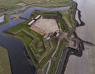
Tilbury Fort, also known historically as the Thermitage Bulwark and the West Tilbury Blockhouse, is an artillery fort on the north bank of the River Thames in England. The earliest version of the fort, comprising a small blockhouse with artillery covering the river, was constructed by King Henry VIII to protect London against attack from France as part of his Device programme. It was reinforced during the 1588 Spanish Armada invasion scare, after which it was reinforced with earthwork bastion, and Parliamentary forces used it to help secure the capital during the English Civil War of the 1640s. Following naval raids during the Anglo-Dutch Wars, the fort was enlarged by Sir Bernard de Gomme from 1670 onwards to form a star-shaped defensive work, with angular bastions, water-filled moats and two lines of guns facing onto the river.

<span class="mw-page-title-main">Dover Western Heights</span>

The Western Heights of Dover are one of the most impressive fortifications in Britain. They comprise a series of forts, strong points and ditches, designed to protect the country from invasion. They were created in the 18th and 19th centuries to augment the existing defences and protect the key port of Dover from both seaward and landward attack; by the start of the 20th century Dover Western Heights was collectively reputed to be the 'strongest and most elaborate' fortification in the country. The Army finally withdrew from the Heights in 1956–61; they are now a local nature reserve.

Grain Fort is a former artillery fort located just east of the village of Grain, Kent. It was constructed in the 1860s to defend the confluence of the Rivers Medway and Thames during a period of tension with France. The fort's location enabled its guns to support the nearby Grain Tower and Garrison Point Fort at Sheerness on the other side of the Medway. It was repeatedly altered and its guns upgraded at various points in its history, before being decommissioned in 1956 when the UK abolished its coastal defence programme. It was subsequently demolished. The remnants of the fort are still visible and have been incorporated into a coastal park.

<span class="mw-page-title-main">Garrison Point Fort</span>

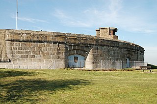
Garrison Point Fort is a former artillery fort situated at the end of the Garrison Point peninsula at Sheerness on the Isle of Sheppey in Kent. Built in the 1860s in response to concerns about a possible French invasion, it was the last in a series of artillery batteries that had existed on the site since the mid-16th century. The fort's position enabled it to guard the strategic point where the River Medway meets the Thames. It is a rare example of a two-tiered casemated fort – one of only two of that era in the country – with a design that is otherwise similar to that of several of the other forts along the lower Thames. It remained operational until 1956 and is now used by the Sheerness Docks as a port installation.

<span class="mw-page-title-main">Slough Fort</span>

Slough Fort is a small artillery fort that was built at Allhallows-on-Sea in the north of the Hoo Peninsula in Kent. Constructed in 1867, the D-shaped fort was intended to guard a vulnerable stretch of the River Thames against possible enemy landings during a period of tension with France. Its seven casemates initially accommodated rifled breech loading guns, which were replaced by the turn of the century by more powerful breech-loaders on disappearing carriages, mounted in concrete wing batteries on either side of the fort. It was likely one of the smallest of the forts constructed as a result of the 1860s invasion scare.

<span class="mw-page-title-main">New Tavern Fort</span>

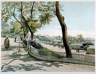
New Tavern Fort is an historic artillery fort in Gravesend, Kent. Dating mostly from the 18th and 19th centuries, it is an unusually well-preserved example of an 18th-century fortification and remained in use for defensive purposes until the Second World War. It was built during the American War of Independence to guard the Thames against French and Spanish raiders operating in support of the newly formed United States of America. It was redesigned and rebuilt in the mid-19th century to defend against a new generation of iron-clad French warships.

<span class="mw-page-title-main">Coalhouse Fort</span> Artillery fort at Coalhouse Point in Essex, England

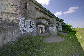
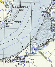
Coalhouse Fort is an artillery fort in the eastern English county of Essex. It was built in the 1860s to guard the lower Thames from seaborne attack. It stands at Coalhouse Point on the north bank of the river, at a location near East Tilbury which was vulnerable to raiders and invaders. It was the last in a series of fortifications dating back to the 15th century and was the direct successor to a smaller mid-19th century fort built on the same site. Constructed during a period of tension with France, its location on marshy ground caused problems from the start and led to a lengthy construction process. The fort was equipped with a variety of large-calibre artillery guns and the most modern defensive facilities of the time, including shell-proof casemates protected by granite facing and cast-iron shields. Its lengthy construction and the rapid pace of artillery development at the time meant that it was practically obsolete for its original purpose within a few years of its completion.

<span class="mw-page-title-main">Harwich Redoubt</span> Fort built in 1808-10 to defend Harwich from revolutionary France

Harwich Redoubt is a circular fort built in 1808 to defend the port of Harwich, Essex from Napoleonic invasion. The Harwich Society opens it to the public.

<span class="mw-page-title-main">Fort Gilkicker</span>

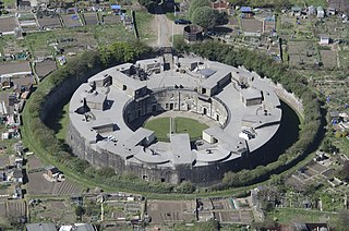
Fort Gilkicker is a historic Palmerston fort built at the eastern end of Stokes Bay, Gosport, Hampshire England to dominate the key anchorage of Spithead. It was erected between 1863 and 1871 as a semi-circular arc with 22 casemates, to be armed with five twelve-inch guns, seventeen ten-inch guns and five nine-inch guns. The actual installed armament rather differed from this. In 1902 the RML guns were replaced by two 9.2-inch and two six-inch BL guns, and before the First World War the walls were further strengthened with substantial earthwork embankments. The fort was disarmed in 1956 and used for storage until 1999, and is currently in a state of disrepair.

<span class="mw-page-title-main">Fort Fareham</span> Palmerston Fort in Fareham

Fort Fareham is one of the Palmerston Forts, in Fareham, England. After the Gosport Advanced Line of Fort Brockhurst, Fort Elson, Fort Rowner, Fort Grange and Fort Gomer had been approved by the Royal Commission on the Defence of the United Kingdom a decision was made to build an outer line of three more forts two miles in advance of the Gosport Advanced Line. Of these three projected forts only Fort Fareham was built due to the need to cut costs. It acted as a hinge between the forts on Portsdown Hill and those of the Gosport Advanced Line, filling the gap at Fareham. It has been a Grade II Listed Building since 1976.

<span class="mw-page-title-main">Fort Nelson, Hampshire</span> Palmerston fort in Boarhunt

Fort Nelson, in the civil parish of Boarhunt in the English county of Hampshire, is one of five defensive forts built on the summit of Portsdown Hill in the 1860s, overlooking the important naval base of Portsmouth. It is now part of the Royal Armouries, housing their collection of artillery, and a Grade I Listed Building.

<span class="mw-page-title-main">Cliffe Fort</span> Disused military installation in Kent, England

Cliffe Fort is a disused artillery fort built in the 1860s to guard the entrance to the Thames from seaborne attack. Constructed during a period of tension with France, it stands on the south bank of the river at the entrance to Cliffe Creek in the Cliffe marshes on the Hoo Peninsula in North Kent, England. Its location on marshy ground caused problems from the start and necessitated changes to its design after the structure begin to crack and subside during construction. The fort was equipped with a variety of large-calibre artillery guns which were intended to support two other nearby Thamesside forts. A launcher for the Brennan torpedo—which has been described as the world's first practical guided missile—was installed there at the end of the 19th century but was only in active use for a few years.

<span class="mw-page-title-main">Fort Ballance</span> Historic site in Point Gordon, Wellington

Fort Ballance is a former coastal artillery battery on Point Gordon on Wellington's Miramar Peninsula.

<span class="mw-page-title-main">Grain Tower</span> 19th-century English gun tower

Grain Tower is a mid-19th-century gun tower situated offshore just east of Grain, Kent, standing in the mouth of the River Medway. It was built along the same lines as the Martello towers that were constructed along the British and Irish coastlines in the early 19th century and is the last-built example of a gun tower of this type. It owed its existence to the need to protect the important dockyards at Sheerness and Chatham from a perceived French naval threat during a period of tension in the 1850s.

<span class="mw-page-title-main">Buena Vista Barracks and Battery</span>

Buena Vista Battery was an artillery battery near the Buena Vista Barracks at the southern end of the British Overseas Territory of Gibraltar. It is located on a slight ridge in front of the nearby Buena Vista Barracks, which was once the base of the Royal Gibraltar Regiment.

<span class="mw-page-title-main">Victoria Battery</span>

Victoria Battery was an artillery battery in the British Overseas Territory of Gibraltar. It was built in the 1840s on top of the earlier Princess of Wales Batteries following a report by Major-General Sir John Thomas Jones on Gibraltar's defences. The battery was located on the west side of Gibraltar and was one of a number of "retired" batteries in the territory, constructed to improve the coastal defences between Europa Point and the town.

<span class="mw-page-title-main">Twydall Profile</span>

The Twydall Profile was a style of fortification used in British and Imperial polygonal forts at the end of the 19th century. The sloping earthworks employed in the Twydall Profile were intended to be quick and inexpensive to construct and to be effective in the face of the more powerful artillery and high explosive ammunition being introduced at that time. The name comes from the village of Twydall in Kent, where the first forts of this type were built.

<span class="mw-page-title-main">Fort Davis, County Cork</span>

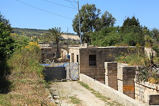
Fort Davis, is a coastal defence fortification close to Whitegate, County Cork, Ireland. Together with similar structures at Fort Mitchel, Fort Camden (Crosshaven), and Templebreedy Battery, the fort was built to defend the mouth of Cork Harbour. Though used as a fortification from the early 17th century, the current structures of the 74-acre site date primarily from the 1860s. Originally named Fort Carlisle and operated by the British Armed Forces, the fort was handed-over to the Irish Defence Forces in 1938, and renamed Fort Davis. The facility is owned by the Department of Defence, and is used as a military training site with no public access.

<span class="mw-page-title-main">Tarġa Battery</span>

Tarġa Battery is an artillery battery on the boundary between St. Paul's Bay and Mosta, Malta. It was built in 1887 by the British as part of the Victoria Lines. The battery is now in the hands of the Mosta Local Council, who intend to restore it and open it to the public.

<span class="mw-page-title-main">Point Battery</span>

Point Battery is a former gun emplacement on Portsmouth Point in Hampshire. Part of the fortifications of Portsmouth, it was built alongside an earlier defensive structure to help defend Portsmouth Harbour in the event of an attack. Fort Blockhouse on the other side of the harbour entrance was rebuilt at around the same time as part of the same scheme. In the mid-19th century the battery was enlarged and Point Barracks were built alongside, to house the artillery troops responsible for manning the defences.
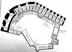
References

  1. 1 2 Lowry, Bernard (2006). Discovering Fortifications: From the Tudors to the Cold War. Princes Risborough: Shire Publications. p. 45. ISBN   978-0-7478-0651-6.
  2. 1 2 3 4 5 6 Victor Smith (Autumn 1971). "Shornemead Fort, near Gravesend". Kent Archaeological Review (25).
  3. 1 2 Lowry, p. 60
  4. 1 2 Sutherland, R. J. M.; Humm, Dawn; Chrimes, Mike (2001). Historic Concrete: Background to Appraisal. Thomas Telford. pp. 372–3. ISBN   978-0-7277-2875-3.
  5. 1 2 Wilson, J.D. (December 1963). "Later Nineteenth Century Defences of the Thames, including Grain Fort". Journal of the Society for Army Historical Research. XLI (168): 182.
  6. Lowry, p. 88
  7. 1 2 3 4 5 6 7 8 "Shornmead Fort" (PDF). Victorian Forts. Retrieved 1 June 2015.
  8. Wilson, J.D. (September 1963). "Later Nineteenth Century Defences of the Thames, including Grain Fort". Journal of the Society for Army Historical Research. XLI (167): 142.
  9. 1 2 3 4 5 Saunders, Andrew; Smith, Victor (2001). "Shornemead Fort – KD 124". Kent's Defence Heritage – Gazetteer Part One. Kent County Council.
  10. "Pastscape – Shornmead Fort". English Heritage. Retrieved 2 June 2015.
  11. "Pastscape – Monument No. 1547569". English Heritage. Retrieved 2 June 2015.
  12. Cowan, Bea (1 January 1996). The Saxon Shore Way. Aurum Press, Limited. p. 45. ISBN   978-1-85410-392-5.