Related Research Articles
Summit Airport is a public-use airport located 5 miles (8.0 km) north of the central business district of Middletown, in New Castle County, Delaware, United States. It is privately owned by Summit Aviation, Inc. It is included in the Federal Aviation Administration (FAA) National Plan of Integrated Airport Systems for 2017–2021, in which it is categorized as a reliever general aviation facility.
Ryan Airfield, also known as Ryan Field, is a city-owned, public-use airport located 12 miles southwest of the central business district of Tucson, a city in Pima County, Arizona, United States. It is included in the National Plan of Integrated Airport Systems for 2011–2015, which categorized it as a reliever airport. It is mostly used for general aviation but also serves a significant amount of law enforcement and military helicopter activity. Approximately 50% of Ryan's traffic is training-related.
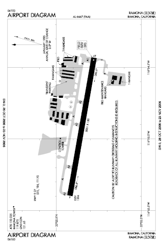
Ramona Airport is a public airport two miles west of Ramona, in San Diego County, California, United States.

Chino Airport is a county-owned airport about three miles southeast of Chino, in San Bernardino County, California, United States. The Federal Aviation Administration's National Plan of Integrated Airport Systems for 2007–2011 classified it as a reliever airport, due to its proximity to the Ontario International Airport and the John Wayne Airport.
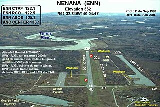
Nenana Municipal Airport is a city-owned public-use airport located one mile (1.6 km) south of the central business district of Nenana, a city in the Yukon-Koyukuk Census Area of the U.S. state of Alaska.
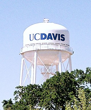
University Airport is a public-use airport located two nautical miles west of the central business district of Davis, a city in Yolo County, California, United States. It is owned by the University of California and operated by Transportation Services of the University of California, Davis. Of the ten campuses in the UC system, Davis is the only one with its own airport.
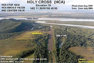
Holy Cross Airport is a state-owned public-use airport located one mile (1.6 km) south of the central business district of Holy Cross, a city in the Yukon-Koyukuk Census Area of the U.S. state of Alaska.
Hanford Municipal Airport, formerly O18, is a mile (1.6 km) southeast of Hanford, in Kings County, California.

Hollister Municipal Airport is a city-owned public-use airport located three nautical miles (6 km) north of the central business district of Hollister, a city in San Benito County, California, United States.

Mariposa-Yosemite Airport is a public airport located four miles (6 km) west of the central business district of Mariposa, in Mariposa County, California, United States. It is owned by the County of Mariposa.

Truckee Tahoe Airport is a public airport two miles east of Truckee, California, United States. The airport is in both Nevada County and Placer County. It is owned by Truckee Tahoe Airport District, a bi-county special district. The FAA's National Plan of Integrated Airport Systems for 2009–2013 called it a general aviation airport.

Tracy Municipal Airport is three miles (5 km) southwest of Tracy, in San Joaquin County, California. It is owned by the City of Tracy.
Cecil Airport is a public airport and commercial spaceport located in Jacksonville, Florida, United States. It is owned by the Jacksonville Aviation Authority and services military aircraft, corporate aircraft, general aviation, and air cargo. The Florida Army National Guard's primary Army Aviation Support Facility and the U.S. Coast Guard's Helicopter Interdiction Tactical Squadron (HITRON) are also located here, the former operating CH-47 Chinook, UH-60 Blackhawk, UH-72 Lakota and C-12 Huron aircraft, and the latter operating the MH-65C Dolphin helicopter.

Manokotak Airport is a state-owned public-use airport located one mile (2 km) north of the central business district of Manokotak, a city in the Dillingham Census Area of the U.S. state of Alaska.

Hampton Roads Executive Airport is a public-use airport seven miles southwest of Norfolk and northwest of Chesapeake, Virginia. It is privately owned by Virginia Aviation Associates, L.L.C.
Ugnu–Kuparuk Airport is a private-use airport located in Kuparuk, Alaska, United States. It is privately owned by ConocoPhillips. which operates the Kuparuk oil field.

Tuntutuliak Airport is a state-owned public-use airport located one nautical mile (1.85 km) south of the central business district of Tuntutuliak, in the Bethel Census Area of the U.S. state of Alaska.

Trona Airport is a public airport five miles north of Trona, in Inyo County, California. It is owned by the United States Department of the Interior, Bureau of Land Management. The National Plan of Integrated Airport Systems for 2011–2015 categorized it as a general aviation facility.
Rio Linda Airport is a public-use airport located one mile (1.6 km) south of Rio Linda, in Sacramento County, California, United States.
References
- 1 2 3 FAA Airport Form 5010 for L61 PDF , effective 2007-07-05
- ↑ Great Circle Mapper: L36 - Shoshone, California