
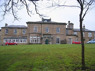
Shotley Hall is a Grade II* listed historic mansion in Shotley Low Quarter, Northumberland, England. [1] It was designed in the Gothic Revival architectural style by Edward Robert Robson, and its construction was completed in 1863. [1] [2]
Shotley Hall is a Grade II* listed historic mansion in Shotley Low Quarter, Northumberland, England. [1] It was designed in the Gothic Revival architectural style by Edward Robert Robson, and its construction was completed in 1863. [1] [2]
The nearby places of High and Low Waskerley were listed as part of the lands of Hugh de Bolbec on his death in 1262 (not to be confused with the Wakserley over the border in Country Durham). By 1313 the land was held by Walter de Huntercombe on his death and then passed into the king's hands while the lands were disputed between John De Lancsater and Ralph fitz William. In 1549 the chapel of Shotley and associated lands, including Waskerley, were granted to Sir Thomas Gargrave, of North Emsall, Yorkshire, and to William Adamson.
The 1663 Book of Rates for Shotley listed the owner as Thomas Mills (listed under "Warscally or Waskerley").
During most of the 18th century the Andrews family of Shotley Hall owned the area eventually selling to the banker Arthur Mowbray of Durham in 1800 who sold off the lands in 1815. For the remainder of the century and until 1916 it belonged to the same owner as Shotley Hall, [3] namely the Wilson and Walton-Wilson family, which included the architect John Wilson Walton-Wilson. [4] [5] [6]

Consett is a town in the County Durham district, in the ceremonial county of Durham, England, about 14 miles (23 km) south-west of Newcastle upon Tyne. It had a population of 27,394 in 2001 and an estimate of 25,812 in 2019.

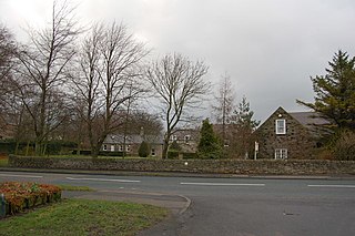
Shotley Bridge is a village, adjoining the town of Consett to the south in County Durham, England, 15 miles North West of Durham City.

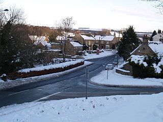
Waskerley is a village in County Durham, England. It is situated six miles to the southwest of Consett and three miles southwest of Castleside and the A68. Stanhope in the Durham Dales is a further six miles to the southwest and the Derwent Reservoir and the village of Edmundbyers is approximately five miles to the north. The village of Muggleswick is three miles to the north.

Allensford is a small country park and hamlet in County Durham, in England. It is on the River Derwent, about 2 miles SW of Consett, and 1 mile north of Castleside.
Benfieldside is a parish in County Durham, in England. Although not a village in its own right, it is signposted and locally known. From a governance point of view it is a ward of Consett with a population taken at the 2011 census of 6,637. The name 'Benfieldside' survives in Benfieldside Road, a school of that name, the local tennis club and the church. Its post office no longer exists, though one remains in the village of Shotley Bridge. The Parish Church is dedicated to St. Cuthbert and is situated on Church Bank. The area is situated directly to the north of Consett, to which it is effectively attached.

Knitsley is a hamlet in and former civil parish, now in the parish of Healeyfield, in the County Durham district, in the ceremonial county of Durham, England. It is situated a short distance to the south of the town of Consett. In 1931 the parish had a population of 2276.
East Law is a small village in County Durham, England. It is situated on the A694 to the north of Consett and north east of Shotley Bridge. It is located south west of Ebchester, of which it can be considered an outlying part.
Ebchester is a village in County Durham, England. It is situated to the north of Consett and to the south east of Whittonstall and the hamlet of Newlands. The village sits at the intersection of the A694, which runs from Consett to Swalwell, and the B6309, which connects the A696 north of Belsay and runs through Whittonstall and Newlands, across the River Derwent, up Chare Bank then through Ebchester itself then past Medomsley into the A691 immediately south of the village of Leadgate.
Medomsley is a village in County Durham, England. It is about 2 miles (3 km) northeast of the centre of Consett, 1+1⁄2 miles (2 km) south of Hamsterley and 1 mile (2 km) southeast of Ebchester along the B6309. Leadgate lies a further mile to the south east.

John Graham Lough was an English sculptor known for his funerary monuments and a variety of portrait sculpture. He also produced ideal classical male and female figures.
This is a list of the High Sheriffs of County Durham, England.
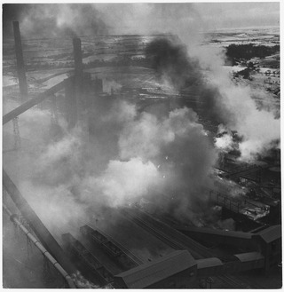
The Consett Iron Company Ltd was an industrial business based in the Consett area of County Durham in the United Kingdom. The company owned coal mines and limestone quarries, and manufactured iron and steel. It was registered on 4 April 1864 as successor to the Derwent & Consett Iron Company Ltd. This in turn was the successor to the Derwent Iron Company, founded in 1840.
The Derwent Valley Railway was a branch railway in County Durham, England. Built by the North Eastern Railway, it ran from Swalwell to Blackhill via five intermediate stations, and onwards to Consett.

St Andrew's Church, Shotley, is a redundant Anglican church standing in an isolated position at a height of 960 feet (293 m) on Greymare Hill in Northumberland, England. It is recorded in the National Heritage List for England as a designated Grade II listed building, and is in the care of the Churches Conservation Trust.
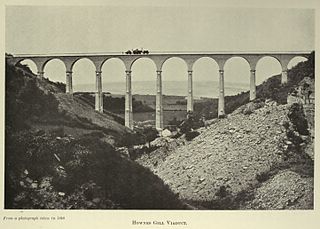
The Hownsgill Viaduct is a former railway bridge located west of Consett in County Durham, England. It is currently used as a footpath and cycleway.
Shotley Park is a former stately home and estate near the town of Shotley Bridge in County Durham, England. It is a listed building with grade II.
John Wilson Walton-Wilson, born John Wilson Walton, was an English architect who designed Anglican churches in the Early Enlgish style. His change of name was a condition by which he inherited Shotley Hall and the Wilson family coat of arms from his uncle Thomas Wilson. He is known for his design of St Augustine's Church, Alston, Cumbria, and for his collaboration with the sculptor Robert Beall in his renovation of St Mary's Church, Nun Monkton North Riding of Yorkshire.

Newlands is a hamlet and former civil parish, now in the parish of Shotley Low Quarter, in the county of Northumberland, England. It is north of Ebchester and south of Whittonstall on the B6309, which follows the route of the ancient Roman road of Watling Street. It is situated north of the River Derwent. The nearest large settlement is Consett to the south west. In 1951 the parish had a population of 71.
![]() Media related to Shotley Hall, Northumberland at Wikimedia Commons
Media related to Shotley Hall, Northumberland at Wikimedia Commons
54°52′08″N1°51′51″W / 54.86887°N 1.86416°W
| | This article about a Northumberland building or structure is a stub. You can help Wikipedia by expanding it. |