Shushartie

Last updated

Shushartie is a ghost town on the east shore of Shushartie Bay near the northeastern extremity of Vancouver Island, British Columbia. [1]

Contents

Name origin

The settlement adopted the name of the bay, which the Hudson's Bay Company conferred in 1838, while trading with First Nations. The name is an adaptation of a Kwakwaka'wakw word meaning "place possessing cockles". Shellfish abound on the extensive tidal flat at the head of the bay. [2] In 1894, Rev. William Washington Bolton led an expedition from near Shushartie, across the northern parts to Quatsino Sound, and then south to Great Central Lake. [3]

The SS Boscowitz was calling as early as 1902. [4] In 1908, a Union Steamship Company of British Columbia (Union SS) vessel arrived weekly. [5] By the early 1910s, the Boscowitz Steamship Co (which became part of the Union SS) called weekly on the run up the east coast of Vancouver Island and the west coast of the mainland to Prince Rupert. [6] During this era, cargo was unloaded at Shushartie for points west to Cape Scott. A weekly private launch trip to Fisherman's Bay (Fisherman's Cove) delivered such freight. [7] The service also catered for passengers along the route. [8]

A trail connected Shushartie and Cape Scott, some of which was of a wagon road standard during the early years. [9] In 1910, a trail linking Shushartie west to Strandby (formerly Cache Creek) was funded. [10] However, residents soon demanded its upgrade to a wagon road. [11] The installation of government telephone lines along the trails connecting Holberg to Cape Scott, San Josef Bay, Sea Otter Cove and Shushartie, [12] was completed in 1915. [13]

Ships docked at a float [14] in the middle of the bay, and craft as small as rowboats ferried passengers and freight to the shore. [15] [16] A later technique involved towing the float to shore for unloading. [17] By the 1960s, the northbound supply boat along the east coast visited monthly. [18]

Former community

In late 1894, six pioneers established a settlement known as the Canadian Co-operative Commonwealth. Four men lived in a log cabin, and a couple resided a little farther down the bay. More settlers were expected in the spring. A rockslide pushed the cabin about 30 metres (100 ft) into the bay. Three escaped with severe bruising, but Harry Kipling's leg was trapped beneath logs. To avoid drowning in the rising tide, Kipling consented to the amputation of his leg with an axe. He died the following afternoon. The missionary steamer Evangelist conveyed the survivors and Kipling's remains to Alert Bay, for passage on the Princess Louise to Victoria. [19]

In the winter of 1902/03, the Boscowitz was towing the Methodist steamer Glad Tidings, when a bad leak added to engine troubles. The latter was beached at Shushartie for the storekeeper to pump out and make seaworthy, before collection on the former's next trip. In the interim, a fierce storm drove the Glad Tidings onto the rocks, where the unsalvageable wreck rested for years. [20]

Jephther J. Skinner, the inaugural postmaster, served 1910–1934, [21] a role commonly performed by a storeowner in such places. [22] Among other enterprises, he ran a hotel, which opened in the early 1910s, [23] and operated at least until 1930. [24] The facility included longer term boarders. [25]

In 1914, Skinner took over the Shushartie–Fisherman's Bay mail run, [26] his series of boats manufactured by the local joinery. [27] Before relocating his shipping route to the west coast, Captain Peterson performed the contract. Skinner named few of his boats, because he was often shipwrecked in the rough seas while completing the monthly route. He once said: "We are on the right Island, but on the wrong end and 50 years too soon." He died ashore in 1934, but had specified a burial at sea, because he had evaded the ocean's attempts to take him many times. [28]

The community population was 25 in 1918, [22] 50 in 1927, [29] 65 in 1930, [30] 48 in 1939, [31] 31 in 1940, [32] and 62 in 1943. [33]

When the post office closed in 1952, [21] the general store likely closed at the same time. Over recent decades, the abandoned buildings within the community have collapsed among the tangle of blackberry vines. [34]

Industry

Fishing

the Goletas Fish Co. operated a cannery 1914–1928. In 1923, Western Packers Ltd., then the Canadian Fishing Co., purchased the venture. On closure, the equipment moved to the Bones Bay Cannery. [35]

The facility promoted the local salmon and halibut fishing industry. [36] The cannery had its own general store for part of this time. [37]

The presence of a fish buyer, at least from the mid-1930s to the late 1940s, [38] indicates that fishing boats sold their coastal catches in the bay.

Forestry

Logging commenced as early as 1907. [39] A sawmill/joinery operated from the early 1910s [25] until the early 1950s. [40] Logging continued in the area at least until the early 1960s. [17]

Tourism

Nowadays, boat or floatplane provides the only eastern access to the North Coast Trail. During the summertime, a water taxi service operates from Port Hardy to the trailhead on the western side of Shushartie Bay. [41] The Cape Scott Provincial Park extends along the northern tip of Vancouver Island from Shushartie Bay in the east, then westward around Cape Scott and south to San Josef Bay.

Footnotes

  1. "Shushartie (locality)". BC Geographical Names .
  2. "Daily Colonist, 3 May 1959". www.archive.org. 1959. p. 15.
  3. "W.W. Bolton Expeditions" (PDF). Archived from the original (PDF) on 22 January 2018.
  4. "Daily Colonist, 8 Apr 1902". www.archive.org. 1902. p. 3.
  5. "The North Coast, 28 Mar 1908". www.library.ubc.ca. p. 4.
  6. "Daily Colonist, 12 Dec 1912". www.archive.org. 1912. p. 15.
  7. "Daily Colonist, 4 Nov 1979". www.archive.org. 1979. p. 5.
  8. "Daily Colonist, 17 May 1927". www.archive.org. 1927. p. 14.
  9. "Daily Colonist, 31 May 1953". www.archive.org. 1953. p. 4.
  10. "Prince Rupert Optimist, 25 Jul 1910". www.library.ubc.ca. p. 3.
  11. "Bella Coola Courier, 2 Aug 1913". www.library.ubc.ca. p. 1.
  12. Paterson & Basque 1999, p. 71.
  13. "Bella Coola Courier, 1 May 1915". www.library.ubc.ca. p. 1.
  14. "Cumberland Islander, 22 Feb 1929". www.library.ubc.ca. p. 1.
  15. Dubreuil, Stephan (1998). Come Quick, Danger A History of Marine Radio in Canada (PDF). www.dfo-mpo.gc.ca. Canadian Government Publishing. p. 109. ISBN   0-660-17490-1.
  16. "Daily Colonist, 12 Mar 1930". www.archive.org. 1930. p. 9.
  17. 1 2 "Daily Colonist, 8 Oct 1961". www.archive.org. 1961. p. 2.
  18. "Daily Colonist, 19 Apr 1967". www.archive.org. 1967. p. 11.
  19. "Sacramento Daily Union, 3 Nov 1894". www.cdnc.ucr.edu. p. 1.
    "Miner (Nelson), 10 Nov 1894". www.library.ubc.ca. p. 4.
    "Nanaimo Daily News, 2 Nov 1894". www.newspapers.com. p. 1.
  20. Scott, Robert C. (1947). "My Captain Oliver". www.library.ubc.ca. United Church of Canada. p. 64 (40).
  21. 1 2 "Postmasters". www.bac-lac.gc.ca.
  22. 1 2 "1918 BC Directory". www.bccd.vpl.ca.
  23. "Bella Coola Courier, 26 Apr 1913". www.library.ubc.ca. p. 1.
  24. "1930 BC Directory". www.bccd.vpl.ca.
  25. 1 2 "Bella Coola Courier, 24 May 1913". www.library.ubc.ca. p. 1.
  26. "Bella Coola Courier, 14 Feb 1914". www.library.ubc.ca. p. 1.
  27. "Bella Coola Courier, 21 Nov 1914". www.library.ubc.ca. p. 1.
  28. "Daily Colonist, 14 Sep 1969". www.archive.org. 1969. p. 10.
  29. "1927 BC Directory". www.bccd.vpl.ca.
  30. "1930 BC Directory". www.bccd.vpl.ca.
  31. "1939 BC Directory". www.bccd.vpl.ca.
  32. "1940 BC Directory". www.bccd.vpl.ca.
  33. "1943 BC Directory". www.bccd.vpl.ca.
  34. Paterson & Basque 1999, p. 74.
  35. "Shusartie Cannery". www.tidestotins.ca. 11 December 2017.
  36. "Bella Coola Courier, 1 Aug 1914". www.library.ubc.ca. p. 1.
  37. "1919 BC Directory". www.bccd.vpl.ca.
    to "1924 BC Directory". www.bccd.vpl.ca.
  38. "1936 BC Directory". www.bccd.vpl.ca.
    to "1948 BC Directory". www.bccd.vpl.ca.
  39. "Week, 16 Mar 1907". www.library.ubc.ca. p. 7.
  40. "1952 BC Directory". www.bccd.vpl.ca.
  41. "North Coast Trail". www.bcparks.ca.

Related Research Articles

<span class="mw-page-title-main">Rogers Pass (British Columbia)</span> Mountain pass in British Columbia, Canada

Rogers Pass is a high mountain pass through the Selkirk Mountains of British Columbia, but the term also includes the approaches used by the Canadian Pacific Railway (CP) and the Trans-Canada Highway. In the heart of Glacier National Park, this tourism destination since 1886 is a National Historic Site.

Union Bay is south of Hart Creek on the east coast of central Vancouver Island, British Columbia. This Comox Valley community on BC Highway 19A is by road about 93 kilometres (58 mi) north of Nanaimo, and 14 kilometres (9 mi) south of Courtenay.

Roosville is a small farming community immediately north of the Canada–United States border in the East Kootenay region of southeastern British Columbia. On BC Highway 93, the locality is east of Lake Koocanusa, at the southeast corner of Tobacco Plains Indian Reserve No. 2.

<span class="mw-page-title-main">Cape Scott Provincial Park</span> Provincial park

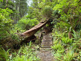
Cape Scott Provincial Park extends from Shushartie in the east, then westward around Cape Scott and south to San Josef Bay. This coastline comprises the northern tip of Vancouver Island, British Columbia. The 22,294-hectare (55,090-acre) provincial park is about 563 km (350 mi) northwest of Victoria.

Holberg is a former ferry terminal about 35 kilometres (22 mi) from the northwest tip of Vancouver Island, British Columbia. This unincorporated community is at the head of Holberg Inlet, which forms the western arm of Quatsino Sound.

Winlaw is an unincorporated community adjacent to Winlaw Creek on the east side of the Slocan River in the West Kootenay region of southeastern British Columbia. The locality is on BC Highway 6 about 20 kilometres (12 mi) south of Slocan, and 49 kilometres (30 mi) north of Castlegar.

Brookmere is an unincorporated community adjacent to Brook Creek in the Nicola region of southern British Columbia. The former railway town, on Coldwater Rd, is by road about 44 kilometres (27 mi) south of Merritt.

<span class="mw-page-title-main">Glacier, British Columbia</span> Settlement in British Columbia, Canada

Glacier, which once comprised small communities, is on the western approach to Rogers Pass in southeastern British Columbia. The name derives from the Great Glacier, which in the 1880s was just over a mile from the original train station.

<span class="mw-page-title-main">Albert Canyon</span> Railway point in British Columbia, Canada

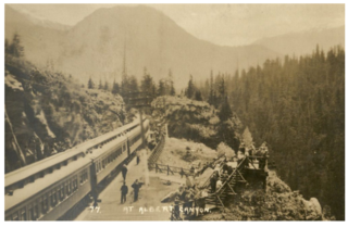
Albert Canyon is about 32 kilometres (20 mi) east of Revelstoke in southeastern British Columbia. The former community no longer exists, but the Canyon Hot Springs Resort borders to its north, both immediately southwest of the Tangier River confluence with the Illecillewaet River.

Cody is at the confluence of Cody Creek into Carpenter Creek in the West Kootenay region of southeastern British Columbia. The ghost town, about one kilometre east of Sandon, lies off BC Highway 31A. By road, the former mining community is about 15 kilometres (9 mi) east of New Denver and 44 kilometres (27 mi) west of Kaslo.

Trout Lake is an unincorporated community in the West Kootenay region of southeastern British Columbia. The former steamboat landing is at the north end of Trout Lake. The locality, on BC Highway 31, is by road about 177 kilometres (110 mi) north of Nelson and 90 kilometres (56 mi) by road and ferry southeast of Revelstoke.

Wynndel is an unincorporated community adjacent to Duck Creek, east of the Kootenay River, in the West Kootenay region of southeastern British Columbia. The locality, on BC Highway 3A, is by road about 11 kilometres (7 mi) north of Creston and 128 kilometres (80 mi) southeast of Nelson.

Thrums is an unincorporated community on the northwest shore of the Kootenay River in the West Kootenay region of southeastern British Columbia. The location, on BC Highway 3A, is by road about 11 kilometres (7 mi) northeast of Castlegar, and 33 kilometres (21 mi) southwest of Nelson.

Vallican is an unincorporated community on the west side of the Slocan River in the West Kootenay region of southeastern British Columbia. At the mouth of the Little Slocan River, the locality formerly spanned both sides of the Slocan River. The rural neighbourhood is off BC Highway 6 about 30 kilometres (19 mi) south of Slocan, and 39 kilometres (24 mi) north of Castlegar.

Johnsons Landing is an unincorporated community in the West Kootenay region of southeastern British Columbia. The former steamboat landing comprises scattered rural properties adjacent to the mouth of Gar Creek. To the north is Gardner Creek and to the south is Fry Creek, the three creek mouths on the northeast shore of Kootenay Lake. The locality, via BC Highway 31 and Argenta Rd, is about 121 kilometres (75 mi) northeast of Nelson.

Kildonan is an unincorporated community in the Alberni Inlet-Barkley Sound region of the west coast of southern Vancouver Island, British Columbia. The former steamboat landing and ferry dock is on the east shore of Uchuchklesit Inlet, which branches northwest of the lower reaches of Alberni Inlet. Adjacent to Pacific Rim National Park Reserve, the locality is by road and ferry about 120 kilometres (75 mi) southwest of Port Alberni.

<span class="mw-page-title-main">Parson, British Columbia</span> Place in British Columbia, Canada

Parson is an unincorporated community on the east shore of the Columbia River, in the Columbia Valley region of southeastern British Columbia. The locality, on BC Highway 95, is by road about 212 kilometres (132 mi) north of Cranbrook and 35 kilometres (22 mi) southeast of Golden.

Harry Bruce Johnston was a Canadian politician, who served in the Legislative Assembly of British Columbia.

Beavermouth is about 43 kilometres (27 mi) west of Golden, and about 32 kilometres (20 mi) east of the mid-point of the Connaught Tunnel beneath Rogers Pass, in southeastern British Columbia. At the mouth of the Beaver River, the train station was called Beavermouth, but the adjacent community, which no longer exists, was known as Beaver or Beaver Mouth. Nowadays, the closest road access is to the nearby Kinbasket Lake Resort.

Strandby is adjacent to the mouth of the Strandby River at the west end of Shuttleworth Bight, near the northeastern extremity of Vancouver Island, British Columbia.

References

Coordinates: 50°51′15″N127°51′15″W / 50.85417°N 127.85417°W / 50.85417; -127.85417 (Shushartie)