Strandby, British Columbia

Last updated
Strandby
Canada British Columbia location map 2.svg
Red pog.svg
Strandby
Location of Strandby in British Columbia
Coordinates: 50°50′19″N128°08′49″W / 50.83861°N 128.14694°W / 50.83861; -128.14694 Coordinates: 50°50′19″N128°08′49″W / 50.83861°N 128.14694°W / 50.83861; -128.14694
CountryFlag of Canada (Pantone).svg  Canada
Province Flag of British Columbia.svg  British Columbia
Region Vancouver Island
Regional District Mount Waddington

Strandby is adjacent to the mouth of the Strandby River [1] at the west end of Shuttleworth Bight, [2] near the northeastern extremity of Vancouver Island, British Columbia.

Contents

Name origin

Cache Creek, the former name, derived from the stream, which, according to an 1892 report, afforded shelter at its mouth for craft drawing not more than 2.1 metres (7 ft). [1] Historically, cache means something of value in a hidden location. One theory claims this referred to the creek itself, which enters the bight at such a sharp angle to be almost invisible from the sea. [3] Furthermore, gold has been detected on the creek, foreshore, and Irony Creek, near the eastern end of the bay. [4] [5]

Another theory alludes to buried treasure. Once a month, early resident Daniel O'Connell would row his 4-metre (12 ft) boat to Shushartie for supplies, but allegedly paid with $20 gold pieces of unknown origin. He drowned on one such trip. [3]

To avoid confusion with the other Cache Creek, the post office opened in 1911 as Strandby, which was Marie Shuttleworth's hometown in Denmark. Both names were used interchangeably for the settlement. Postmaster Skinner at Shushartie, who dropped off the Strandby mail monthly, jokingly called it "Stranded by the Sea". [6] In due course, the stream was called Strandby River, but when officially renamed in 1947, it was misspelled Stranby. The error was detected by local historian Ruth Botel, and officially corrected in 2005. [1]

Early community

Danish settler Soren Christensen, who came in the late 1890s, resided at the mouth of the creek. [3] East of the settlement was Burnt Hill, later renamed Soren Hill. [7] His sister Marie joined him in 1903. [4]

About 1905, Henry (Harry) Shuttleworth arrived, [3] marrying Marie in 1908. He had previously spent the winter of 1896 placer mining for gold on the creek. [4] In their new home, the couple extended hospitality to all travellers between Cape Scott and Shushartie. Their 20 or 30 head of cattle foraged the rainforest, and the descendants still roam wild. Their few domesticated cows provided milk, and Marie made butter and cheese. Harry was community leader and justice of the peace, and at various times served as road foreman and postmaster. [3] [8]

In 1910, a trail linking east to Shushartie was funded. To avoid travel by small launch in choppy waters, [9] residents soon demanded an upgrade to a wagon road. [10] Westward however, little more than a trail could ever become a reality. [11]

Near Daniel O'Connell's place, Peter Wold lived on Burnt Hill, a name evidencing an earlier forest fire. Other permanent residents included Pete and Karl Sovik, the Gundersons, and the Eaglestads. In 1911, the Alec Sims and their twin babies came, soon followed by Harry Shuttleworth's brother Robert with his wife and five children. Robert's family temporarily lived in a new house by the creek before moving 3 kilometres (2 mi) west to Sunny Bay. [3] J. Tom & Dorothy Lockwood and their three sons completed the year's arrivals. The family was musical, and Tom was an Anglican lay preacher. He took over the general store, [6] and was postmaster 1913–1917. [8] Later settlers were drawn by a land promotion on Burnt Hill, but the soil was poor, and the immigrants soon relocated to the fertile foreshore. [3] From 1914, World War I enlistments decimated these communities. [12]

Strandby River cable crossing, 2009 Strandby River Cape Scott.JPG
Strandby River cable crossing, 2009

The installation of government telephone lines along the trails connecting Holberg to Cape Scott, San Josef Bay, Sea Otter Cove and Shushartie [12] was completed in 1915. [13] Little evidence of this line through Strandby remains. [4] That year, Soren Christensen died. [14] The next year, Robert Shuttleworth left for New Westminster to work in a munitions factory. In 1917, the family joined him, promising to return in the spring, but like many, they never resettled after the war. By 1921, Harry & Marie Shuttleworth alone remained at Strandby. The Gundersons, Nockens, and Eaglestads were at Christensen Point, also named after Soren. [15] Just inland from this western point of Sunny Bay lived the Dykes. [6]

Outliving Marie, Henry (Harry) Shuttleworth, then the sole resident, died in 1941. [16]

Tourism

By the 1970s, apart from a shelter for the stranded, only collapsed abandoned buildings remained. [4] The Cape Scott Provincial Park extends along the northern tip of Vancouver Island from Shushartie Bay in the east, then westward around Cape Scott and south to San Josef Bay. The individuals who once inhabited almost every cove have long gone.

Nowadays, the North Coast Trail, which links east to west, borders Shuttleworth Bight, where Strandby occupied the western end. Camping spots exist on the foreshore, and back in the forest when extreme winds. [17] A house/lodge stands on the private property adjacent to the river mouth. To pass this obstacle, the trail skirts inland, [18] crossing the river on a two-person aerial cable. [17]

Related Research Articles

Rogers Pass (British Columbia) Mountain pass in British Columbia, Canada

Rogers Pass is a high mountain pass through the Selkirk Mountains of British Columbia, but the term also includes the approaches used by the Canadian Pacific Railway (CP) and the Trans-Canada Highway. In the heart of Glacier National Park, this tourism destination since 1886 is a National Historic Site.

Burrard Inlet coastal fjord in southwestern British Columbia

Burrard Inlet is a relatively shallow-sided coastal fjord in southwestern British Columbia, Canada. Formed during the last Ice Age, it separates the City of Vancouver and the rest of the low-lying Burrard Peninsula from the slopes of the North Shore Mountains, home to the communities of West Vancouver and the City and District of North Vancouver.

Union Bay, British Columbia Place in British Columbia, Canada

Union Bay is south of Hart Creek on the east coast of central Vancouver Island, British Columbia. This Comox Valley community on BC Highway 19A is by road about 93 kilometres (58 mi) north of Nanaimo, and 14 kilometres (9 mi) south of Courtenay.

Cape Scott Provincial Park

Cape Scott Provincial Park is a provincial park located at the cape of the same name, which is the northwestern tip of Vancouver Island, British Columbia, Canada, and located 563 km (350 mi) from Victoria. It was established in 1973 with about 37,200 acres (15,100 ha), and later expanded to approximately 22,294 hectares. Lanz and Cox Islands Provincial Park, formerly Scott Islands Marine Provincial Park, is offshore, to the northwest of Cape Scott.

Miracle Beach Provincial Park

Miracle Beach Provincial Park is a provincial park on the eastern shore of Vancouver Island in British Columbia, Canada. Located between Comox and Campbell River, the park includes a foreshore area in the Strait of Georgia, much of the Black Creek estuary, and a forested area. According to its Master Plan, it fulfills primarily a recreational role with a focus on beach play, picnicking, nature appreciation, and camping, and a secondary conservation role with a focus on the natural shoreline and estuary. I support of its recreational focus the park is developed with a day-use parking area with accessible trails leading to the shoreline and a camping area with 200 drive-in sites. The park is also hosts a nature centre building and a sheltered group picnic shelter. Vegetation in the park is typical for the region's second-growth forests with Douglas-fir most prominent. Common associates include Western hemlock, Sitka spruce, red alder and bigleaf maple. Salal and sword fern are the most abundant shrub. Black Creek, which flows through the park, is a spawning area for coho salmon.

Bulkley Valley

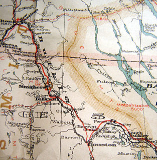
The Bulkley Valley is in the northwest Central Interior of British Columbia, Canada.

Holberg, British Columbia Place in British Columbia, Canada

Holberg is a former ferry terminal about 35 kilometres (22 mi) from the northwest tip of Vancouver Island, British Columbia. This unincorporated community is at the head of Holberg Inlet, which forms the western arm of Quatsino Sound.

Syringa Provincial Park

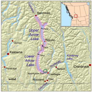
Syringa Park is a provincial park on the east shore of Lower Arrow Lake in the West Kootenay region of southeastern British Columbia. At the foot of the Norns Range, Tulip Creek passes through the centre, and Syringa Creek is closer to the southeastern boundary. The park is about 19 kilometres (12 mi) west of Castlegar via Broadwater Rd.

Tweedsmuir South Provincial Park

Tweedsmuir South Provincial Park is a provincial park covering parts of the eastern Kitimat Ranges, northern Pacific Ranges, and the Rainbow Range in British Columbia, Canada. It was established on May 21, 1938 to protect a vast area of pristine wilderness in the western interior of the province.

North Coast Trail

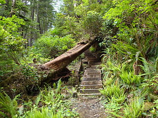
The North Coast Trail is a 43.1 km (26.8 mi) wilderness hiking trail in Cape Scott Provincial Park on northern Vancouver Island, British Columbia, Canada.

Glacier, British Columbia

Glacier, which once comprised small communities, is on the western approach to Rogers Pass in southeastern British Columbia. The name derives from the Great Glacier, which in the 1880s was just over a mile from the original train station.

Robson Bight is a small Vancouver Island bay at the west end of Johnstone Strait across from West Cracroft Island in British Columbia, Canada that includes a protected killer whale habitat famous for its whale-rubbing beaches. The bight is adjacent to Lower Tsitika River Provincial Park. The nearest access point is Telegraph Cove on the east coast of Northern Vancouver Island.

The Big Bend is the northernmost section of the Columbia River, which changes from a northwestward course along the Rocky Mountain Trench to curve around the northern end of the Selkirk Mountains to head southwest between that range and the Monashee Mountains, which lie to the west. The area is part of the larger Columbia Country, which includes the Columbia Valley and upper Arrow Lakes of eastern British Columbia. The 2,300 square miles (6,000 km2) north of the railway line, and enclosed by the river, roughly defines the Big Bend. However, in earlier eras, the descriptive was more narrowly understood.

Rock Creek, British Columbia Place in British Columbia, Canada

Rock Creek is in the Boundary Country region of south central British Columbia. The unincorporated settlement is mostly on the southwest side of the Kettle River at the confluence with Rock Creek. The place lies at the junction of BC Highway 33, and BC Highway 3.

Hunlen Falls

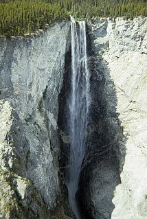
Hunlen Falls is a waterfall located at the mouth of Turner Lake in the Pacific Ranges of British Columbia, Canada. With an estimated height of 260 m (850 ft), it is tied with Takakkaw Falls in Yoho National Park for having the fourth tallest single drop of any waterfall in Canada.

Tarrys Place in British Columbia, Canada

Tarrys is an unincorporated community spanning both shores of the Kootenay River in the West Kootenay region of southeastern British Columbia. The location, on BC Highway 3A, is by road about 14 kilometres (9 mi) northeast of Castlegar, and 30 kilometres (19 mi) southwest of Nelson.

Edgewood, British Columbia Place in British Columbia, Canada

Edgewood is a settlement on the west shore of Lower Arrow Lake in the West Kootenay region of southeastern British Columbia. The former steamboat landing is between the mouths of Inonoaklin Creek and Eagle Creek. The locality, off BC Highway 6, is by road about 136 kilometres (85 mi) southeast of Vernon and 76 kilometres (47 mi) by road and ferry southwest of Nakusp.

Lemon Creek is an unincorporated community on the east side of the Slocan River in the West Kootenay region of southeastern British Columbia. The locality is on BC Highway 6 about 8 kilometres (5 mi) south of Slocan, and 62 kilometres (39 mi) north of Castlegar.

Shushartie is a ghost town on the east shore of Shushartie Bay near the northeastern extremity of Vancouver Island, British Columbia.

Beavermouth (railway point), British Columbia Railway point in British Columbia, Canada

Beavermouth is about 43 kilometres (27 mi) west of Golden, and about 32 kilometres (20 mi) east of the mid-point of the Connaught Tunnel beneath Rogers Pass, in southeastern British Columbia. At the mouth of the Beaver River, the train station was called Beavermouth, but the adjacent community, which no longer exists, was known as Beaver or Beaver Mouth. Nowadays, the closest road access is to the nearby Kinbasket Lake Resort.

References

  1. 1 2 3 "Strandby River (river)". BC Geographical Names.
  2. "Shuttleworth Bight (bight)". BC Geographical Names.
  3. 1 2 3 4 5 6 7 "Daily Colonist, 7 Sep 1969". www.archive.org. pp. 4–5.
  4. 1 2 3 4 5 "Daily Colonist, 18 Feb 1973". www.archive.org. p. 11.
  5. "Irony Creek (creek)". BC Geographical Names.
  6. 1 2 3 "Daily Colonist, 14 Sep 1969". www.archive.org. pp. 14–15.
  7. "Soren Hill (hill)". BC Geographical Names.
  8. 1 2 "Postmasters". www.bac-lac.gc.ca.
  9. "Prince Rupert Optimist, 25 Jul 1910". www.library.ubc.ca. p. 3.
  10. "Bella Coola Courier, 2 Aug 1913". www.library.ubc.ca. p. 1.
  11. "Daily Colonist, 29 Apr 1913". www.archive.org. p. 5.
  12. 1 2 Paterson, T.W.; Basque, G. (1999). Ghost Towns & Mining Camps of Vancouver Island. Sunfire Publications. p. 71. ISBN   1-895811-80-5.
  13. "Bella Coola Courier, 1 May 1915". www.library.ubc.ca. p. 1.
  14. "Death Certificate (Soren CHRISTENSEN)". www.royalbcmuseum.bc.ca.
  15. "Christensen Point (point)". BC Geographical Names.
  16. "Province, 5 Jul 1941". www.newspapers.com. p. 21.
  17. 1 2 "North Coast Trail: Shuttleworth Bight/Irony Creek Campsite; Laura Creek". www.10adventures.com.
  18. The BC Coast Explorer , p. 44, at Google Books