
Katra is a city and Tehsil in the Reasi district of the Indian union territory of Jammu and Kashmir, situated at the foot of the Trikuta Mountains, where the shrine of Vaishno Devi is located. Katra is located 24 km from the town of Reasi, 42 km (26 mi) from the city of Jammu and around 685 km (426 mi) north of the national capital New Delhi and is the base for pilgrims visiting the Mata Vaishno Devi Temple.
The Jammu–Baramulla line is a railway track being laid to connect the Kashmir Valley in the Indian union territory of Jammu and Kashmir with Jammu railway station and thence to the rest of the country. The 338 km railway track will start from Jammu and end at Baramulla. This Rail project from Jammu to Baramula was being initiated by Prime Minister Smt. Indira Gandhi in 1983 & in 1991 Congres Government at Centre led by Prime Minister Shri PV Narshimha Rao & erstwhile union Railway minister Shri C.K.Jaffer Sharief sanctioned the huge funds to connect mainland India i.e. Jammu to Kashmir Valley till Baramulla Later in 2002 Prime Minister Shri Atal Bihari Vajpayee announced this project as National Project.Some of the section of this Railway Project was being inaugurated by Prime Minister Dr. Manmohan Singh in 2008, 2009 & 2013 & later in 2014 & 2024 Prime Minister Narendra Modi also inaugurated some section of this Railway Project.It comes under the jurisdiction of the Firozpur railway division of Indian Railways' Northern zone. Part of this railway route from Udhampur to Baramulla is known as Jammu Udhampur-Srinagar-Baramula Rail Link (JUSBRL). The 359 m (1,178 ft) tall Chenab Bridge lies on this line, which is the tallest railway bridge in the world. The total project cost in 2022 was INR28,000 crore.

Poonch or Punch is a district of the Jammu division of Indian-administered Jammu and Kashmir in the disputed Kashmir region. With headquarters in the town of Poonch, it is bounded by the Line of Control on three sides. The 1947–48 war between India and Pakistan divided the earlier district into two parts. One went to Pakistan and the other became part of the then-Indian state of Jammu and Kashmir.

Rajouri is a district in the Jammu division of Indian-administered Jammu and Kashmir in the disputed Kashmir region. The Line of Control, between the Indian- and Pakistani-administered Jammu and Kashmir, lies to its west, Poonch to its north, the Reasi district to the east and the Jammu district to its south. Rajouri is famous for its "Kalari". Representing an ancient principality, Rajouri was a joint district, along with Reasi, at the time of princely state's accession to India in 1947. The two tehsils were separated and Rajouri was merged with the Poonch district. Rajouri again became a separate district along with Reasi in 1968 till 2006 when both were separated again. The Rajouri district comprises 13 tehsils (boroughs). The land is mostly fertile and mountainous. Maize, wheat and rice are the main crops of the area and the main source of the irrigation is the river Tawi that originates from the mountains of Pir Panjal.
Rajouri or Rajauri is a city in the Rajouri district in the Jammu division of the Indian union territory of Jammu and Kashmir. It is located about 155 kilometres (96 mi) from Srinagar and 150 km (93 mi) from Jammu city on the Poonch Highway. The city is the location of the birthplace of Sikh General Banda Singh Bahadur. Baba Ghulam Shah Badshah University is also situated in this district. It is Known as The Land of Kings. The Jarral Rajputs were the Highest Ruling Dynasty of The Rajouri District. They Ruled Rajouri For 657 Years. Raja Nooruddin Khan Established Jarral Dynasty in The Land of Kings.

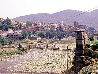
Reasi is a town and a notified area committee and tehsil in Reasi district of the Indian union territory of Jammu and Kashmir. Situated on the bank of River Chenab, It is the headquarters of the Reasi district. In the eighth century, Reasi was a part of the Bhimgarh state established by Rajput king Bhim Dev Rasyal. The name Reasi is derived from the town's old name, "Rasyal".

Kotli is a city in Kotli District of Azad Kashmir in Pakistan. It lies on the Poonch River, and the river contains several waterfalls, including the Lala Waterfall near the town of Kotli, and the Gulpur Waterfalls at the village of Gulpur to the southwest. As per the 2017 Census of Pakistan, Kotli had a population of 46,907.

Reasi district is an administrative district in the Jammu division of Indian state of Jammu and Kashmir in the Jammu region. The Reasi district is bordered by Udhampur district and Ramban district in the east, Jammu district in the south, Rajouri district in the west and by Kulgam district on the north. The Reasi and Rajouri tehsils formed a joint district called the "Reasi district" at the time of the princely state's accession to India in 1947. As part of the reorganisation, the two tehsils were separated and Reasi was merged with the Udhampur district. It again became a separate district in 2006.

Jammu and Kashmir is home to several valleys such as the Kashmir Valley, Chenab Valley, Sindh Valley and Lidder Valley. Some major tourist attractions in Jammu and Kashmir are Srinagar, with its renowned Dal Lake and Mughal Gardens, Gulmarg, Pahalgam, Bhaderwah, Patnitop and Jammu. Every year, thousands of Hindu pilgrims visit holy shrines of Vaishno Devi and Amarnath which has had a significant impact on the state's economy.
Udhampur Lok Sabha constituency is one of the six Lok Sabha (parliamentary) constituencies in Jammu and Kashmir in northern India. The constituency covers 20,230 square kilometres of mountainous Himalayan terrain, and is comparable to the size of Israel. It is composed of the districts of Kishtwar, Ramban, Kathua, Doda, Reasi, and Udhampur. Udhampur constituency's population is over 2,400,000, and exceeds the population of New Mexico. The seat from 1967-1980 was held by Karan Singh, the former crown prince of Jammu and Kashmir.

The Ganderbal district, is an Indian-administered district in Jammu and Kashmir in the disputed Kashmir region. It was formed in 2007 and has 6 subdistricts (tehsils): Kangan, Ganderbal, Tullamulla, Wakura, Lar, and Gund.

Kulgam district is an administrative district of Indian-administered Jammu and Kashmir in the disputed Kashmir region. It is in the Kashmir division and is located at a distance of 18 kilometres (11 mi) towards south-west of Anantnag. The district comprises block, tehsil and town of Kulgam.

The Banihal-Qazigund Railway Tunnel or Pir Panjal railway tunnel is an 11.215 kilometres (6.969 mi) long railway tunnel located in Pir Panjal Range of middle Himalayas in Jammu and Kashmir, India, south of Qazigund town. It is a part of the Jammu–Baramulla line.
Chowki Choura, Akhnoor, is a Sub-Division in Jammu district in Jammu and Kashmir, India.

The Jalandhar–Jammu line is a railway line connecting Jalandhar Cantonment and Jalandhar City in the Indian state of Punjab with Jammu Tawi in Jammu and Kashmir. The line is under the administrative jurisdiction of Northern Railway. This line was made after Indian Independence in 1947. Normally before partition of India and creation of Pakistan, trains to Jammu Tawi from Delhi used to run via Panipat, Ambala Cantonment, Ludhiana, Jalandhar City, Amritsar, Lahore, Narowal and Sialkot. But after partition and creation of Pakistan in 1947, the Sialkot–Jammu Tawi line was dismantled and closed permanently. Jammu and Kashmir became cut off from rest of India. Hence in 1949, it was decided to extend the line from Jalandhar City to Mukerian till Pathankot and after the Indo-Pakistani War of 1965, this line was extended to Jammu Tawi. This 216 km (134 mi) railway line is an important strategic connectivity for Indian Military and Defence.

The Jammu division is a revenue and administrative division of the Indian-administered Jammu and Kashmir in the disputed Kashmir region. It is bordered by the Kashmir division to the north. It consists of the districts of Jammu, Doda, Kathua, Ramban, Reasi, Kishtwar, Poonch, Rajouri, Udhampur and Samba. Most of the land is hilly or mountainous, including the Pir Panjal Range which separates it from the Kashmir Valley and part of the Great Himalayas in the eastern districts of Doda and Kishtwar. Its principal river is the Chenab.

Jammu is a city in Indian-administered Jammu and Kashmir in the disputed Kashmir region. It is the winter capital of Jammu and Kashmir, which is an Indian-administered union territory. It is the headquarters and the largest city in Jammu district. Lying on the banks of the river Tawi, the city of Jammu, with an area of 240 km2 (93 sq mi), is surrounded by the Himalayas in the north and the northern plains in the south. Jammu is the second-most populous city of the union territory. Jammu is known as "City of Temples" for its ancient temples and Hindu shrines.
Mandi is a town and a tehsil in the Poonch district of the Indian union territory of Jammu and Kashmir. Mandi is located in east of the Poonch district, about 171 kilometres (106 mi) from Srinagar and 1 kilometre (0.62 mi) south of the Line of Control with Pakistan. The Ancient Hindu temple Baba Budha Amernath is located here.
Dudu is a village and municipality in Udhampur district of the Indian union territory of Jammu and Kashmir. The town is located 100 kilometres from the district headquarters Udhampur.
Pouni is a village and municipality in Reasi district of the Indian union territory of Jammu and Kashmir. The town is located 25 km from the district headquarters Reasi Town.


