Algiers is the administrative, political and economic capital and largest city of Algeria as well as the capital of the Algiers Province. The city's population at the 2008 census was 2,988,145 and in 2020 was estimated to be around 4,500,000. Located in the north-central part of the country, it extends along the shores of the Bay of Algiers in the heart of the Maghreb region making it classified among the biggest cities in North Africa, the Arab world and the Mediterranean, making it a major center of culture, arts, gastronomy and trade.

As the tenth-largest country in the world, and the largest in Africa and in the Mediterranean region, Algeria has a vast transportation system that includes a large and diverse transportation infrastructure.

Tabelbala is a town and commune between Béchar and Tindouf in south-western Algeria, and is the capital, and only significant settlement, of the Daïra of the same name, encompassing most of the western half of Béni Abbès Province. As of the 2008 census, its population was 5,121, up from 4,663 in 1998, with an annual growth rate of 1.0%. The commune covers an area of 60,560 square kilometres (23,380 sq mi), making it by far the largest commune in the province, as well as the least densely populated.

Annaba, formerly known as Bon, Bona and Bône, is a seaport city in the northeastern corner of Algeria, close to the border with Tunisia. Annaba is near the small Seybouse River and is in the Annaba Province. With a population of about 464,740 (2019) and 1,000,000 for the metropolitan area, Annaba is the third-largest city and the leading industrial center in Algeria.
Staouéli is a municipality in Algiers Province, Algeria. It is located in Zéralda district, on a Presque-isle on the Mediterranean Sea, hosting the resort town of Sidi Fredj. There was a Grand Prix circuit located in Staouéli. Grands Prix was held there from 1928 to 1930, but the circuit is no longer operational.

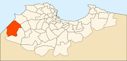
Algiers Province is a province (wilayah) in Algeria, named after its capital, Algiers, which is also the national capital. It is adopted from the old French department of Algiers and has a population of about 8 million. It is the most densely populated province of Algeria, and also the smallest by area.

Rouïba or Rouiba is a municipality of Algeria. It is located 22 kilometres (14 mi) in the eastern suburbs of Algiers in one of the most healthy localities of Algeria. It is also the district seat of Rouïba District in Algiers Province. Its inhabitants are called Rouibéens.

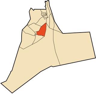
Reghaïa is a municipality in Algiers Province, Algeria. It is located in Rouïba district and is the most populated municipality of the district.

Béni Abbès, also known as the Pearl of the Saoura, and also as the White Oasis, is a town and commune located in western Algeria in Béchar Province, 241 km (150 mi) far from the provincial capital Béchar, and 1,200 km (746 mi) from Algiers.

Tazoult is commune town in north-eastern Algeria.

The National Rail Transportation Company is Algeria's national railway operator. The SNTF, a state-owned company, currently has a monopoly over Algeria's rail network of 3,973 km (2,469 mi), although it is currently utilising only 3,572 km (2,220 mi). Out of the total railway network, 2,888 km (1,795 mi) are 1,435 mmstandard gauge and 1,085 km (674 mi) are 1,055 mm narrow gauge.
Méridja is a town and commune in Kénadsa District, Béchar Province, in western Algeria. As of 2008 the population of the commune was 592, up from 532 in 1998, with an annual growth rate of 1.1%. This makes it the smallest commune by population in Béchar Province. The commune covers an area of 2,270 square kilometres (880 sq mi).
Thénia (الثنية), sometimes written as Thenia, with around 40,000 inhabitants, is the chief town in the daïra of the same name, in the wilaya of Boumerdès, in northern Algeria. Historically, the name is a contraction of "Theniet Beni Aicha", the Arabic translation of the Kabyle Berber toponym Tizi n At Ɛica. The steep-sided pass, which is only about 800 metres (2,600 ft) wide at its narrowest point, is sometimes taken to mark the transition between Mitidja and Grande Kabylie.

Sidi Moussa is a commune in the Baraki District of the Algiers Province and a suburb of the city of Algiers in northern Algeria. It is situated 15 km (9.3 mi) south of central Algiers.
Hassi Ben Abdellah is a town and commune in Sidi Khouiled District, Ouargla Province, Algeria, located near the provincial capital, Ouargla. According to the 2008 census it has a population of 4,950, up from 3,693 in 1998, and an annual growth rate of 3.0%. The commune covers an area of 1,672 square kilometres (646 sq mi).

Sidi Khouiled is a town and commune, and capital of Sidi Khouiled District, in Ouargla Province, Algeria. It is located near the provincial capital, Ouargla. According to the 2008 census it has a population of 8,803, up from 4,309 in 1998, and has an annual population growth rate of 7.6%, the highest in the province.

Sidi Ghiles is a town on Algeria's Mediterranean coast. The municipality of Novi is located about 32 kilometres (20 mi) west of Tipasa and 7 kilometres (4.3 mi) southwest of Cherchell. This agricultural locality is 100 kilometres (62 mi) from Algiers.

Tadmaït is a town and commune in Tizi Ouzou Province in northern Algeria, located 18 kilometers west of Tizi Ouzou and 85 kilometers east of Algiers.

The history of rail transport in Algeria began in 1857 during the French colonization with the implementation of an initial plan for the creation of a 1,357 kilometres (843 mi) railway network. This plan, formalized by a decree from Emperor Napoleon III, defined the initial framework of the Algerian railway network, which continued to evolve throughout the second half of the 19th century, both in terms of its scale and structure.
The Réghaïa forest or Kadous forest is a forest located in Réghaïa in the wilaya of Algiers, Algeria.