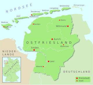
East Frisia or East Friesland is a historic region in modern Lower Saxony, Germany. The modern province is primarily located on the western half of the East Frisian peninsula, to the east of West Frisia and to the west of Landkreis Friesland but is known to have extended much further inland before modern representations of the territory. Administratively, East Frisia consists of the districts Aurich, Leer and Wittmund and the city of Emden. It has a population of approximately 469,000 people and an area of 3,142 square kilometres (1,213 sq mi).

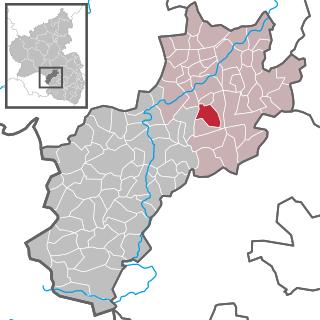
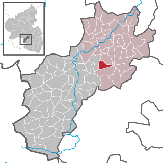
Auen is an Ortsgemeinde – a municipality belonging to a Verbandsgemeinde, a kind of collective municipality – in the Bad Kreuznach district in Rhineland-Palatinate, Germany. It belongs to the Verbandsgemeinde of Bad Sobernheim, whose seat is in the like-named town. Auen is a tourism-oriented community and a state-recognized recreational area.

Dagebüll is a municipality located at the west coast of Schleswig-Holstein in the Nordfriesland district, Germany. Today's Dagebüll was created in 1978 as a merger of the municipalities of Fahretoft, Juliane-Marien-Koog and Waygaard. Dagebüll used to be a Hallig, the oldest houses were built on artificial dwelling hills which in parts can still be seen today. In 1704 the area was secured by sea dikes.

Wyk auf Föhr is the only town on Föhr, the second largest of the North Frisian Islands on the German coast of the North Sea. Like the entire island it belongs to the district of Nordfriesland. Wyk includes the two minor town districts of Boldixum and Südstrand.

Upgant-Schott is a municipality in the district of Aurich, in Lower Saxony, Germany.

Aschbach is an Ortsgemeinde – a municipality belonging to a Verbandsgemeinde, a kind of collective municipality – in the Kusel district in Rhineland-Palatinate, Germany. It belongs to the Verbandsgemeinde Lauterecken-Wolfstein.

Hinzweiler is an Ortsgemeinde – a municipality belonging to a Verbandsgemeinde, a kind of collective municipality – in the Kusel district in Rhineland-Palatinate, Germany. It belongs to the Verbandsgemeinde Lauterecken-Wolfstein.

Nerzweiler is an Ortsgemeinde – a municipality belonging to a Verbandsgemeinde, a kind of collective municipality – in the Kusel district in Rhineland-Palatinate, Germany. It belongs to the Verbandsgemeinde Lauterecken-Wolfstein.

Oberweiler im Tal is an Ortsgemeinde – a municipality belonging to a Verbandsgemeinde, a kind of collective municipality – in the Kusel district in Rhineland-Palatinate, Germany. It belongs to the Verbandsgemeinde Lauterecken-Wolfstein.

Dickenschied is an Ortsgemeinde – a municipality belonging to a Verbandsgemeinde, a kind of collective municipality – in the Rhein-Hunsrück-Kreis (district) in Rhineland-Palatinate, Germany. It belongs to the Verbandsgemeinde of Kirchberg, whose seat is in the like-named town.

Korweiler is an Ortsgemeinde – a municipality belonging to a Verbandsgemeinde, a kind of collective municipality – in the Rhein-Hunsrück-Kreis (district) in Rhineland-Palatinate, Germany. It belongs to the Verbandsgemeinde of Kastellaun, whose seat is in the like-named town.

Wenningstedt-Braderup is a municipality and seaside resort on the island of Sylt in the district of Nordfriesland, in Schleswig-Holstein, Germany. It is located north of the town of Westerland and is part of the Amt Landschaft Sylt. The local economy is dominated by tourism.

Eastermar is a village in Tytsjerksteradiel municipality in the province Friesland of the Netherlands. It had around 1,575 citizens in January 2017.

The formerly independent village of Wiegboldsbur in East Frisia in North Germany has been part of the municipality of Südbrookmerland since the regional reform of 1972. Wiegboldsbur is a ribbon development (Reihensiedlung) and lies on the Großes Meer about 10 km northwest of the seaport of Emden. The parish chair is Bernhard Behrends (SPD).

Pewsum is a village in the municipality of Krummhörn in the west of East Frisia, in Lower Saxony, Germany. Pewsum is both the administrative seat as well as the trade and craft centre of the municipality. The number of inhabitants was 3,352 in 2006 and the village lies at a height of 0 m above sea level (NN).

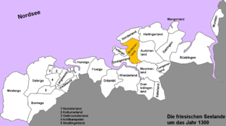
The Brokmerland is a landscape and historic territory, located in western East Frisia, which covers the area in and around the present-day communities of Brookmerland and Südbrookmerland. The Brokmerland borders in the east on the Harlingerland and in the north on the Norderland. The historic Brokmerland is usually written with only one "o". Occasionally one also finds the spelling "Broekmerland", while today's communities have chosen to spell the name with a double "o".

Bedekaspel is an East Frisian village in Lower Saxony, Germany. It is an Ortsteil of the municipality of Südbrookmerland. It is located near the Großes Meer. A Haufendorf, the village of Bedekaspel includes Wochenendsiedlung, a recreational area on the northern shore of the Großes Meer, and Bedekaspeler Marsch.

Berum is a village in the region of East Frisia, Lower Saxony, Germany. It is an Ortsteil of the municipality of Hage, part of the municipal association (Samtgemeinde) of Hage, although its metropolitan area practically borders that of the nearby town of Berumbur, to which it is located to the west.

Westerbur is an East Frisian village in Lower Saxony, Germany. It is an Ortsteil of the municipality of Dornum, in the district of Aurich. Administratively, the settlement of Middelsbur, located slightly to the northeast, belongs to Westerbur.

Münkeboe is an East Frisian village in Lower Saxony, Germany. It is an Ortsteil of the municipality of Südbrookmerland, in the district of Aurich. It is located southwest of the Ewiges Meer and approximately 8 kilometers northwest of Aurich.


